
McLean County (Illinois)
 McLean County Courthouse |
|
| administration | |
|---|---|
| US state : | Illinois |
| Administrative headquarters : | Bloomington |
| Address of the administrative headquarters: |
McLean County 104 West Front Street Bloomington Illinois 61701 |
| Foundation : | December 25, 1830 |
| Made up from: | Tazewell County |
| Area code : | 001 309 |
| Demographics | |
| Residents : | 169,572 (2010) |
| Population density : | 55.3 inhabitants / km 2 |
| geography | |
| Total area : | 3072 km² |
| Water surface : | 7 km² |
| map | |
 |
|
| Website : www.mcleancountyil.gov | |
The McLean County is a county in the US -amerikanischen State Illinois . In 2010 , the county had 169,572 people and a population density of 55.3 people per square kilometer. The county seat is Bloomington .
geography
The county is north of central Illinois and the Mackinaw River flows through it in an east-west direction . It has an area of 3,072 square kilometers, of which seven square kilometers are water. The following neighboring counties border McLean County:
| Woodford County | Livingston County | |
| Tazewell County |
.svg)
|
Ford County Champaign County |
| Logan County | DeWitt County | Piatt County |
history

| Population development | |||
|---|---|---|---|
| Census | Residents | ± in% | |
| 1840 | 6565 | - | |
| 1850 | 10.163 | 54.8% | |
| 1860 | 28,772 | 183.1% | |
| 1870 | 53,988 | 87.6% | |
| 1880 | 60,100 | 11.3% | |
| 1890 | 63,036 | 4.9% | |
| 1900 | 67,843 | 7.6% | |
| 1910 | 68.008 | 0.2% | |
| 1920 | 70.107 | 3.1% | |
| 1930 | 73.117 | 4.3% | |
| 1940 | 73.930 | 1.1% | |
| 1950 | 76,577 | 3.6% | |
| 1960 | 83,877 | 9.5% | |
| 1970 | 104,389 | 24.5% | |
| 1980 | 119.149 | 14.1% | |
| 1990 | 129,180 | 8.4% | |
| 2000 | 150,433 | 16.5% | |
| 2010 | 169,572 | 12.7% | |
| Before 1900 1900–1990 2000 2010 | |||
McLean County was formed on December 25, 1830 from parts of Tazewell County. It was named after John McLean (1791-1830), a lawyer and US Senator from Illinois (1824-1825, 1829-1830).
Territorial development
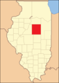
McLean County from its inception in 1830 to 1837

1837 to 1841
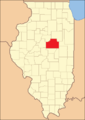
1841 until today


Demographic data
As of the 2010 census , McLean County's population was 169,572 in 63,431 households. The population density was 55.3 inhabitants per square kilometer. Statistically, 2.5 people lived in each of the 63,431 households.
The racial the population was composed of 85.5 percent white, 7.6 percent African American, 0.3 percent Native American, 4.5 percent Asian and other ethnic groups; 2.1 percent were descended from two or more races. Hispanic or Latino of any race was 4.6 percent of the population.
22.3 percent of the population were under 18 years old, 67.3 percent were between 18 and 64 and 10.4 percent were 65 years or older. 51.4 percent of the population was female.
The median income for a household was 59,410 USD . The per capita income was $ 29,425. 13.4 percent of the population lived below the poverty line.
McLean County localities
1 - partly in Woodford County
2 - partly in DeWitt County
structure
McLean County is divided into 30 townships :

The city of Bloomington does not belong to any township.
See also
Individual evidence
- ↑ GNIS-ID: 1784833. Retrieved on February 22, 2011 (English).
- ↑ a b c U.S. Census Bureau, State & County QuickFacts - McLean County, IL ( Memento of the original from July 14, 2011 on WebCite ) Info: The archive link was automatically inserted and not yet checked. Please check the original and archive link according to the instructions and then remove this notice. Retrieved December 22, 2012
- ^ A b National Association of Counties. Retrieved December 22, 2012
- ^ US Census Bureau - Census of Population and Housing.Retrieved March 15, 2011
- ^ Extract from Census.gov.Retrieved February 15, 2011
- ↑ Missouri Census Data Center - Illinois ( page no longer available , search in web archives ) Info: The link was automatically marked as defective. Please check the link according to the instructions and then remove this notice. Retrieved December 22, 2012
Web links
List of counties in Illinois
Adams |
Alexander |
Bond |
Boone |
Brown |
Bureau |
Calhoun |
Carroll |
Cass |
Champaign |
Christian |
Clark |
Clay |
Clinton |
Coles |
Cook |
Crawford |
Cumberland |
DeKalb |
DeWitt |
Douglas |
DuPage |
Edgar |
Edwards |
Effingham |
Fayette |
Ford |
Franklin |
Fulton |
Gallatin |
Greene |
Grundy |
Hamilton |
Hancock |
Hardin |
Henderson |
Henry |
Iroquois |
Jackson |
Jasper |
Jefferson |
Jersey |
Jo Daviess |
Johnson |
Kane |
Kankakee |
Kendall |
Knox |
LaSalle |
Lake |
Lawrence |
Lee |
Livingston |
Logan |
Macon |
Macoupin |
Madison |
Marion |
Marshall |
Mason |
Massac |
McDonough |
McHenry |
McLean |
Menard |
Mercer |
Monroe |
Montgomery |
Morgan |
Moultrie |
Ogle |
Peoria |
Perry |
Piatt |
Pike |
Pope |
Pulaski |
Putnam |
Randolph |
Richland |
Rock Island |
Saline |
Sangamon |
Schuyler |
Scott |
Shelby |
St. Clair |
Strong |
Stephenson |
Tazewell |
Union |
Vermilion |
Wabash |
Warren |
Washington |
Wayne |
White |
Whiteside |
Will |
Williamson |
Winnebago |
Woodford
Coordinates: 40 ° 29 ′ N , 88 ° 51 ′ W