Henry County (Illinois)
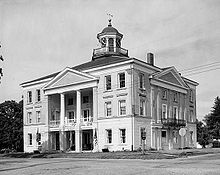
![The Henry County Courthouse in Cambridge, listed in the NRHP since 2004 [1]](https://upload.wikimedia.org/wikipedia/commons/thumb/f/fe/Henry_County_Courthouse_%28Cambridge%2C_Illinois%29.jpg/298px-Henry_County_Courthouse_%28Cambridge%2C_Illinois%29.jpg) The Henry County Courthouse in Cambridge, listed on the NRHP since 2004 |
|
| administration | |
|---|---|
| US state : | Illinois |
| Administrative headquarters : | Cambridge |
| Address of the administrative headquarters: |
Henry County Courthouse 307 W. Center St Cambridge, IL 61238 |
| Foundation : | January 13, 1825 |
| Made up from: | Original County |
| Area code : | 001 309 |
| Demographics | |
| Residents : | 50,486 (2010) |
| Population density : | 23.7 inhabitants / km 2 |
| geography | |
| Total area : | 2138 km² |
| Water surface : | 6 km² |
| map | |
| Website : www.henrycty.com | |
The Henry County is a county in the US -amerikanischen State Illinois . In 2010 the county had 50,486 residents and a population density of 23.7 people per square kilometer. The county seat is Cambridge .
geography
The county is located in northwest Illinois and has an area of 2,138 square kilometers, of which six square kilometers are water. It borders on the following neighboring counties:
| Rock Island County | Whiteside County | |
| Mercer County |

|
Bureau County |
| Knox County | Stark County |
history
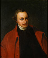
Henry County was formed in the Illinois Territory on January 13, 1825 and named after Patrick Henry (1736–1799), a lawyer, statesman, and congressman . He was the first and sixth governor of Virginia .
The Carroll, Jo Daviess, Knox, Rock Island and Whiteside Counties were formed from Henry County. Between 1846 and 1861, over 1,000 Swedish settlers came to Henry County and built the Bishop Hill colony .
Demographic data
| Population development | |||
|---|---|---|---|
| Census | Residents | ± in% | |
| 1830 | 41 | - | |
| 1840 | 1260 | 2,973.2% | |
| 1850 | 3807 | 202.1% | |
| 1860 | 20,660 | 442.7% | |
| 1870 | 35.506 | 71.9% | |
| 1880 | 36,597 | 3.1% | |
| 1890 | 33,338 | -8.9% | |
| 1900 | 40,049 | 20.1% | |
| 1910 | 41,736 | 4.2% | |
| 1920 | 45.162 | 8.2% | |
| 1930 | 43,851 | -2.9% | |
| 1940 | 43,798 | -0.1% | |
| 1950 | 46,492 | 6.2% | |
| 1960 | 49,317 | 6.1% | |
| 1970 | 53,217 | 7.9% | |
| 1980 | 57,968 | 8.9% | |
| 1990 | 51,159 | -11.7% | |
| 2000 | 51.020 | -0.3% | |
| 2010 | 50,486 | -1 % | |
| Before 1900 1900–1990 2000 2010 | |||
According to the 2010 census , Henry County had 50,486 people in 20,433 households. The population density was 23.7 inhabitants per square kilometer. Statistically, 2.44 people lived in the 20,433 households.
The racial the population was composed of 96.3 percent white, 1.8 percent African American, 0.3 percent Native American, 0.4 percent Asian and other ethnic groups; 1.2 percent were descended from two or more races. Hispanic or Latino of any race was 4.9 percent of the population.
23.5 percent of the population were under 18 years old, 59.1 percent were between 18 and 64 and 17.4 percent were 65 years or older. 50.2 percent of the population was female.
The median income for a household was 49,164 USD . The per capita income was $ 24,915. 10.4 percent of the population lived below the poverty line.
Henry County localities
1 - partly in Rock Island County
2 - mostly in Mercer County
structure
Henry County is divided into 24 townships :
|
|
See also
Individual evidence
- ↑ Extract from the National Register of Historic Places - No. 04000869.Retrieved July 13, 2012
- ↑ GNIS-ID: 424238. Retrieved on February 22, 2011 (English).
- ↑ a b c U.S. Census Bureau, State & County QuickFacts - Henry County, IL ( Memento of the original from July 11, 2011 on WebCite ) Info: The archive link was automatically inserted and not yet checked. Please check the original and archive link according to the instructions and then remove this notice. Retrieved December 7, 2012
- ↑ a b National Association of Counties. Retrieved December 7, 2012
- ^ US Census Bureau - Census of Population and Housing.Retrieved March 15, 2011
- ^ Extract from Census.gov.Retrieved February 15, 2011
- ^ Extract from the National Register of Historic Places . Retrieved March 13, 2011
- ↑ Missouri Census Data Center - Illinois ( page no longer available , search in web archives ) Info: The link was automatically marked as defective. Please check the link according to the instructions and then remove this notice. Retrieved December 7, 2012
Web links
Coordinates: 41 ° 21 ′ N , 90 ° 8 ′ W


