
Peoria County
 Peoria County Courthouse |
|
| administration | |
|---|---|
| US state : | Illinois |
| Administrative headquarters : | Peoria |
| Address of the administrative headquarters: |
Peoria County Courthouse 324 Main Street Peoria, Illinois 61602 |
| Foundation : | January 13, 1825 |
| Made up from: | Sangamon County |
| Area code : | 001 309 |
| Demographics | |
| Residents : | 186,494 (2010) |
| Population density : | 116.2 inhabitants / km 2 |
| geography | |
| Total area : | 1634 km² |
| Water surface : | 29 km² |
| map | |
 |
|
| Website : www.co.peoria.il.us | |
The Peoria County is a county in the US -amerikanischen State Illinois . In 2010 , the county had 186,494 residents and a population density of 116.2 people per square kilometer. The county seat is Peoria .
geography
The county is located in central northwest Illinois on the right bank of the Illinois River , which expands to Peoria Lake in front of the city of Peoria .
The county has an area of 1634 square kilometers, of which 29 square kilometers are water.
The following neighboring counties border Peoria County:
| Knox County | Stark County | Marshall County |
.svg)
|
Woodford County | |
| Fulton County | Tazewell County |
Protected areas

history
| Population development | |||
|---|---|---|---|
| Census | Residents | ± in% | |
| 1840 | 6153 | - | |
| 1850 | 17,547 | 185.2% | |
| 1860 | 36,601 | 108.6% | |
| 1870 | 47,540 | 29.9% | |
| 1880 | 55,355 | 16.4% | |
| 1890 | 70,378 | 27.1% | |
| 1900 | 88,608 | 25.9% | |
| 1910 | 100,255 | 13.1% | |
| 1920 | 111.710 | 11.4% | |
| 1930 | 141,344 | 26.5% | |
| 1940 | 153.374 | 8.5% | |
| 1950 | 174,347 | 13.7% | |
| 1960 | 189,044 | 8.4% | |
| 1970 | 195.318 | 3.3% | |
| 1980 | 200,466 | 2.6% | |
| 1990 | 182,827 | -8.8% | |
| 2000 | 183,433 | 0.3% | |
| 2010 | 186.494 | 1.7% | |
| Before 1900 1900–1990 2000 2010 | |||
Peoria County was formed on January 13, 1825 from parts of Sangamon County . It was named after the Peoria , an Indian tribe of the Illinois Confederation.
Territorial development
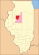
Peoria County from its inception in 1825 to 1826

1826 to 1827
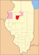
1827 to 1830

1830 to 1831

1831 until today


Demographic data
According to the 2010 census , Peoria County had 186,494 people in 75,416 households. The population density was 116.2 inhabitants per square kilometer. Statistically, 2.38 people lived in each of the 75,416 households.
The racial the population was composed of 75.7 percent white, 17.9 percent African American, 0.4 percent Native American, 3.3 percent Asian and other ethnic groups; 2.6 percent were descended from two or more races. Hispanic or Latino of any race was 4.0 percent of the population regardless of ethnicity.
24.1 percent of the population were under 18 years old, 61.9 percent were between 18 and 64 and 14.0 percent were 65 years or older. 51.5 percent of the population was female.
The median income for a household was 50,689 USD . The per capita income was $ 28,743. 15.4 percent of the population lived below the poverty line.
Localities in Peoria County
Census-designated places (CDP)
1 - predominantly in Tazewell County
structure
Peoria County is divided into 20 townships :
|
|
See also
Individual evidence
- ↑ GNIS-ID: 1784920. Retrieved on February 22, 2011 (English).
- ↑ a b c U.S. Census Bureau, State & County QuickFacts - Peoria County, IL ( Memento of the original from July 16, 2011 on WebCite ) Info: The archive link was automatically inserted and has not yet been checked. Please check the original and archive link according to the instructions and then remove this notice. Retrieved December 26, 2012
- ^ A b National Association of Counties.Retrieved December 26, 2012
- ^ US Census Bureau - Census of Population and Housing.Retrieved March 15, 2011
- ^ Extract from Census.gov.Retrieved February 15, 2011
- ↑ Missouri Census Data Center - Illinois ( page no longer available , search in web archives ) Info: The link was automatically marked as defective. Please check the link according to the instructions and then remove this notice. Retrieved December 26, 2012
Web links
List of counties in Illinois
Adams |
Alexander |
Bond |
Boone |
Brown |
Bureau |
Calhoun |
Carroll |
Cass |
Champaign |
Christian |
Clark |
Clay |
Clinton |
Coles |
Cook |
Crawford |
Cumberland |
DeKalb |
DeWitt |
Douglas |
DuPage |
Edgar |
Edwards |
Effingham |
Fayette |
Ford |
Franklin |
Fulton |
Gallatin |
Greene |
Grundy |
Hamilton |
Hancock |
Hardin |
Henderson |
Henry |
Iroquois |
Jackson |
Jasper |
Jefferson |
Jersey |
Jo Daviess |
Johnson |
Kane |
Kankakee |
Kendall |
Knox |
LaSalle |
Lake |
Lawrence |
Lee |
Livingston |
Logan |
Macon |
Macoupin |
Madison |
Marion |
Marshall |
Mason |
Massac |
McDonough |
McHenry |
McLean |
Menard |
Mercer |
Monroe |
Montgomery |
Morgan |
Moultrie |
Ogle |
Peoria |
Perry |
Piatt |
Pike |
Pope |
Pulaski |
Putnam |
Randolph |
Richland |
Rock Island |
Saline |
Sangamon |
Schuyler |
Scott |
Shelby |
St. Clair |
Strong |
Stephenson |
Tazewell |
Union |
Vermilion |
Wabash |
Warren |
Washington |
Wayne |
White |
Whiteside |
Will |
Williamson |
Winnebago |
Woodford
Coordinates: 40 ° 47 ′ N , 89 ° 46 ′ W