
Randolph County (Illinois)
 Randolph County Courthouse |
|
| administration | |
|---|---|
| US state : | Illinois |
| Administrative headquarters : | Chester |
| Address of the administrative headquarters: |
County Courthouse 1 Taylor Street Chester, IL 62233-1970 |
| Foundation : | October 5, 1795 |
| Made up from: | St. Clair County |
| Area code : | 001 618 |
| Demographics | |
| Residents : | 33,476 (2010) |
| Population density : | 22.3 inhabitants / km 2 |
| geography | |
| Total area : | 1547 km² |
| Water surface : | 49 km² |
| map | |
 |
|
| Website : www.randolphco.org | |
The Randolph County is a county in the US -amerikanischen State Illinois . In 2010 , the county had 33,476 residents and a population density of 22.3 people per square kilometer. The county seat is Chester .
geography
The county is located in southwest Illinois at the confluence of the Kaskaskia River with the Mississippi , which also forms the border with Missouri . It has an area of 1547 square kilometers, of which 49 square kilometers are water. The following neighboring counties border Randolph County:
| Monroe County | St. Clair County | Washington County |
.svg)
|
Perry County | |
|
Ste. Genevieve County, Missouri |
Perry County, Missouri |
Jackson County |
history

| Population development | |||
|---|---|---|---|
| Census | Residents | ± in% | |
| 1800 | 1103 | - | |
| 1810 | 7275 | 559.6% | |
| 1820 | 3492 | -52% | |
| 1830 | 4429 | 26.8% | |
| 1840 | 7944 | 79.4% | |
| 1850 | 11,079 | 39.5% | |
| 1860 | 17.205 | 55.3% | |
| 1870 | 20,859 | 21.2% | |
| 1880 | 25,690 | 23.2% | |
| 1890 | 25,049 | -2.5% | |
| 1900 | 28.001 | 11.8% | |
| 1910 | 29,120 | 4% | |
| 1920 | 29,109 | -0% | |
| 1930 | 29,313 | 0.7% | |
| 1940 | 33,608 | 14.7% | |
| 1950 | 31,673 | -5.8% | |
| 1960 | 29,988 | -5.3% | |
| 1970 | 31,379 | 4.6% | |
| 1980 | 35,652 | 13.6% | |
| 1990 | 34,583 | -3% | |
| 2000 | 33,893 | -2% | |
| 2010 | 33,476 | -1.2% | |
| Before 1900 1900–1990 2000 2010 | |||
Randolph County was formed from part of St. Clair County in the Illinois Territory on October 5, 1795 , 23 years before the state was founded. It was named after Edmund Randolph (1753–1813), a former governor of Virginia (1786–1788) and later Secretary of State of the United States (1794–1795).
Randolph County's history begins with the indigenous people of various tribes who settled in the area. The area was first explored by Europeans in 1673 when Louis Joliet and Jacques Marquette of Canada came down the Mississippi River . The next European would have been La Salle , who came via the southern route and began his expedition in 1682. He named the initial area based on the French king Louisiana and took possession of it for France. He may also have been the founder of Kaskaskia and Cahokia. There is evidence that he founded Fort St. Louis . This gave the French access to this area.
The next conqueror was the Frenchman Phillip Renault . He founded St. Phillips in 1719 in the southwest of what is now Monroe County. He began to build mines in search of gold and silver. This led to an enlargement of the explored area, but he found nothing. Fort Chartres was built by a Boisbriant from 1720 , and Kaskaskia was a trading post in 1721.
In 1762 the Treaty of Fontainebleau was signed between the French and the British, whereby all French possessions east of the Mississippi fell to the British. As a result, the previously sparsely populated land emptied again, as many French did not want to live in the now British-administered area and British settlers slowly moved into this area. The American settlers began with the settlement after 1778. Until 1809 the area, like most of today's Illinois, was under different rule before it became the Free Territory of Illinois.
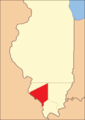
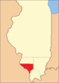
Territorial development

Randolph County until 1812
1812 to 1813
1813 to 1816

1816 to 1827
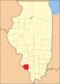
1827 until today


Demographic data
According to the 2010 census , Randolph County had 33,476 people in 12,093 households. The population density was 22.3 inhabitants per square kilometer. Statistically, there were 2.33 people in each of the 12,093 households.
The racial the population was composed of 87.6 percent white, 9.7 percent African American, 0.2 percent Native American, 0.3 percent Asian and other ethnic groups; 0.9 percent were descended from two or more races. Hispanic or Latino of any race was 2.6 percent of the population regardless of ethnicity.
20.8 percent of the population were under 18 years old, 63.4 percent were between 18 and 64 and 15.8 percent were 65 years or older. 45.9 percent of the population was female.
The median income for a household was 43,160 USD . The per capita income was $ 19,938. 13.3 percent of the population lived below the poverty line.
Randolph County localities
structure
Randolph County is divided into 20 precincts :
|
|
See also
Individual evidence
- ↑ GNIS-ID: 1784967. Retrieved on February 22, 2011 (English).
- ↑ a b c U.S. Census Bureau, State & County QuickFacts - Randolph County, IL Retrieved January 3, 2013
- ↑ a b National Association of Counties.Retrieved January 3, 2013
- ^ US Census Bureau - Census of Population and Housing.Retrieved March 15, 2011
- ^ Extract from Census.gov.Retrieved February 15, 2011
- ↑ Missouri Census Data Center - Illinois ( page no longer available , search in web archives ) Info: The link was automatically marked as defective. Please check the link according to the instructions and then remove this notice. Retrieved January 3, 2013
Web links
List of counties in Illinois
Adams |
Alexander |
Bond |
Boone |
Brown |
Bureau |
Calhoun |
Carroll |
Cass |
Champaign |
Christian |
Clark |
Clay |
Clinton |
Coles |
Cook |
Crawford |
Cumberland |
DeKalb |
DeWitt |
Douglas |
DuPage |
Edgar |
Edwards |
Effingham |
Fayette |
Ford |
Franklin |
Fulton |
Gallatin |
Greene |
Grundy |
Hamilton |
Hancock |
Hardin |
Henderson |
Henry |
Iroquois |
Jackson |
Jasper |
Jefferson |
Jersey |
Jo Daviess |
Johnson |
Kane |
Kankakee |
Kendall |
Knox |
LaSalle |
Lake |
Lawrence |
Lee |
Livingston |
Logan |
Macon |
Macoupin |
Madison |
Marion |
Marshall |
Mason |
Massac |
McDonough |
McHenry |
McLean |
Menard |
Mercer |
Monroe |
Montgomery |
Morgan |
Moultrie |
Ogle |
Peoria |
Perry |
Piatt |
Pike |
Pope |
Pulaski |
Putnam |
Randolph |
Richland |
Rock Island |
Saline |
Sangamon |
Schuyler |
Scott |
Shelby |
St. Clair |
Strong |
Stephenson |
Tazewell |
Union |
Vermilion |
Wabash |
Warren |
Washington |
Wayne |
White |
Whiteside |
Will |
Williamson |
Winnebago |
Woodford
Coordinates: 38 ° 3 ′ N , 89 ° 49 ′ W