
LaSalle County
.jpg) LaSalle County Courthouse |
|
| administration | |
|---|---|
| US state : | Illinois |
| Administrative headquarters : | Ottawa |
| Address of the administrative headquarters: |
LaSalle Courthouse 119 W. Madison Street Ottawa, IL 61350 |
| Foundation : | January 15, 1831 |
| Made up from: |
Putnam County Illinois Territory |
| Area code : | 001 815 |
| Demographics | |
| Residents : | 113,924 (2010) |
| Population density : | 38.8 inhabitants / km 2 |
| geography | |
| Total area : | 2973 km² |
| Water surface : | 34 km² |
| map | |
 |
|
| Website : www.lasallecounty.org | |
The LaSalle County is a county in the US -amerikanischen State Illinois . In 2010 , the county had 113,924 residents and a population density of 38.8 people per square kilometer. The county seat is Ottawa .
geography
The county is located in north central Illinois. It has an area of 2973 square kilometers, of which 34 square kilometers are water surface. The county is traversed by the Illinois River and its tributary, the Fox River , which flows into Ottawa. The following neighboring counties border LaSalle County:
| Lee County | DeKalb County | Kendall County |
|
Bureau County Putnam County |
.svg)
|
Grundy County |
| Marshall County | Woodford County | Livingston County |
history

| Population development | |||
|---|---|---|---|
| Census | Residents | ± in% | |
| 1840 | 9348 | - | |
| 1850 | 17,815 | 90.6% | |
| 1860 | 48,332 | 171.3% | |
| 1870 | 60,792 | 25.8% | |
| 1880 | 70,403 | 15.8% | |
| 1890 | 80,798 | 14.8% | |
| 1900 | 87,776 | 8.6% | |
| 1910 | 90.132 | 2.7% | |
| 1920 | 92,925 | 3.1% | |
| 1930 | 97,695 | 5.1% | |
| 1940 | 97,801 | 0.1% | |
| 1950 | 100,610 | 2.9% | |
| 1960 | 110,800 | 10.1% | |
| 1970 | 111,409 | 0.5% | |
| 1980 | 112.003 | 0.5% | |
| 1990 | 106,913 | -4.5% | |
| 2000 | 111.509 | 4.3% | |
| 2010 | 113.924 | 2.2% | |
| Before 1900 1900–1990 2000 2010 | |||
LaSalle County was formed on January 15, 1831 from part of Putnam County and part of the Illinois Free Territory. It was named after Robert Cavelier de La Salle , a French conqueror. La Salle was the first white man to set foot on this land. He drove down the Mississippi River to the Gulf of Mexico , took possession of the land for France or King Louis XIV and named it Louisiana . He and two other French merchants built Fort Crèvecœur on the Illinois River near today's Peoria in 1680 on the territory of LaSalle County and in 1662 Fort St. Louis on Starved Rock . In 1857 the county was already served daily by 2 trains on the Illinois Central Railroad .
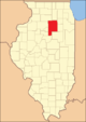
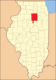
Territorial development

LaSalle County from its inception in 1831 to 1836

1836 to 1837

1837 to 1841
1841 to 1843
1843 until today


Demographic data
As of the 2010 census , LaSalle County had 113,924 people in 45,000 households. The population density was 38.8 inhabitants per square kilometer. Statistically, 2.48 people lived in each of the 45,000 households.
The racial the population was composed of 95.6 percent white, 2.1 percent African American, 0.3 percent Native American, 0.7 percent Asian and other ethnic groups; 1.2 percent were descended from two or more races. Hispanic or Latino of any race was 8.3 percent of the population.
22.8 percent of the population were under 18 years old, 60.7 percent were between 18 and 64 and 16.5 percent were 65 years or older. 50.0 percent of the population was female.
The median income for a household was 52,469 USD . The per capita income was $ 25,439. 10.4 percent of the population lived below the poverty line.
Localities in LaSalle County
Census-designated places (CDP)
Other Unincorporated Communities
|
1 - partly in DeKalb and in Kendall County
|
6 - partly in Grundy County
|
structure
LaSalle County is divided into 37 townships :
|
|
|
See also
Individual evidence
- ↑ GNIS-ID: 422247. Retrieved on February 22, 2011 (English).
- ↑ a b c U.S. Census Bureau, State & County QuickFacts - LaSalle County, IL ( Memento of the original from July 13, 2011 on WebCite ) Info: The archive link was automatically inserted and not yet checked. Please check the original and archive link according to the instructions and then remove this notice. Retrieved December 16, 2012
- ↑ a b National Association of Counties.Retrieved December 16, 2012
- ^ US Census Bureau - Census of Population and Housing.Retrieved March 15, 2011
- ^ Extract from Census.gov.Retrieved February 15, 2011
- ↑ Missouri Census Data Center - Illinois ( page no longer available , search in web archives ) Info: The link was automatically marked as defective. Please check the link according to the instructions and then remove this notice. Retrieved December 16, 2012
Web links
Coordinates: 41 ° 21 ′ N , 88 ° 51 ′ W
List of counties in Illinois
Adams |
Alexander |
Bond |
Boone |
Brown |
Bureau |
Calhoun |
Carroll |
Cass |
Champaign |
Christian |
Clark |
Clay |
Clinton |
Coles |
Cook |
Crawford |
Cumberland |
DeKalb |
DeWitt |
Douglas |
DuPage |
Edgar |
Edwards |
Effingham |
Fayette |
Ford |
Franklin |
Fulton |
Gallatin |
Greene |
Grundy |
Hamilton |
Hancock |
Hardin |
Henderson |
Henry |
Iroquois |
Jackson |
Jasper |
Jefferson |
Jersey |
Jo Daviess |
Johnson |
Kane |
Kankakee |
Kendall |
Knox |
LaSalle |
Lake |
Lawrence |
Lee |
Livingston |
Logan |
Macon |
Macoupin |
Madison |
Marion |
Marshall |
Mason |
Massac |
McDonough |
McHenry |
McLean |
Menard |
Mercer |
Monroe |
Montgomery |
Morgan |
Moultrie |
Ogle |
Peoria |
Perry |
Piatt |
Pike |
Pope |
Pulaski |
Putnam |
Randolph |
Richland |
Rock Island |
Saline |
Sangamon |
Schuyler |
Scott |
Shelby |
St. Clair |
Strong |
Stephenson |
Tazewell |
Union |
Vermilion |
Wabash |
Warren |
Washington |
Wayne |
White |
Whiteside |
Will |
Williamson |
Winnebago |
Woodford