
Sangamon County
 Sangamon County Courthouse |
|
| administration | |
|---|---|
| US state : | Illinois |
| Administrative headquarters : | Springfield |
| Address of the administrative headquarters: |
Sangamon County Building 200 South Ninth Street Springfield, IL 62701-1629 |
| Foundation : | January 30, 1821 |
| Made up from: |
Bond County Madison County |
| Area code : | 001 217 |
| Demographics | |
| Residents : | 197,465 (2010) |
| Population density : | 87.8 inhabitants / km 2 |
| geography | |
| Total area : | 2271 km² |
| Water surface : | 23 km² |
| map | |
 |
|
| Website : www.co.sangamon.il.us | |
The Sangamon County is a county in the US -amerikanischen State Illinois . In 2010 the county had 197,465 residents and a population density of 87.8 people per square kilometer. The county seat is Springfield , which is also the capital of Illinois.
geography
The county is located just west of the geographic center of Illinois. It has an area of 2271 square kilometers, of which 23 square kilometers are water. The county is traversed by the Sangamon River , a left tributary of the Illinois River that flows into the Mississippi . The following neighboring counties border Sangamon County:
| Cass County | Menard County | Logan County |
| Morgan County |
.svg)
|
Macon County |
| Macoupin County | Montgomery County | Christian County |
history
| Population development | |||
|---|---|---|---|
| Census | Residents | ± in% | |
| 1830 | 12,960 | - | |
| 1840 | 14,716 | 13.5% | |
| 1850 | 19,228 | 30.7% | |
| 1860 | 32,274 | 67.8% | |
| 1870 | 46,352 | 43.6% | |
| 1880 | 52,894 | 14.1% | |
| 1890 | 61.195 | 15.7% | |
| 1900 | 71,593 | 17% | |
| 1910 | 91.024 | 27.1% | |
| 1920 | 100,262 | 10.1% | |
| 1930 | 111,733 | 11.4% | |
| 1940 | 117.912 | 5.5% | |
| 1950 | 131,484 | 11.5% | |
| 1960 | 146,539 | 11.5% | |
| 1970 | 161,335 | 10.1% | |
| 1980 | 176.089 | 9.1% | |
| 1990 | 178,386 | 1.3% | |
| 2000 | 188,951 | 5.9% | |
| 2010 | 197,465 | 4.5% | |
| Before 1900 1900–1990 2000 2010 | |||
Sangamon County was formed on January 30, 1821 from the southern parts of Bond and Madison County and was almost twice the size of today. In the same year the first courthouse, a log cabin, was built and cost around 78 dollars including a separate judge's room and other furnishings. In 1837 Springfield was named the capital of Illinois.

Sangamon is home to a site of outstanding national importance, the Lincoln Home National Historic Site . Five places in the county have National Historic Landmark status . 63 buildings and sites in the county are listed on the National Register of Historic Places (NRHP) (as of August 17, 2018).
Territorial development
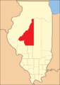
Sangamon County from its founding in 1821 to 1823

1823 to 1825
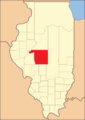
1825 to 1839

1839 until today


Demographic data
According to the 2010 census , Sangamon County had 197,465 people in 82,422 households. The population density was 87.8 people per square kilometer. Statistically, 2.34 people lived in the 82,422 households.
The racial the population was composed of 83.9 percent white, 12.0 percent African American, 0.2 percent Native American, 1.7 percent Asian and other ethnic groups; 2.1 percent were descended from two or more races. Hispanic or Latino of any race was 1.9 percent of the population.
23.5 percent of the population were under 18 years old, 62.5 percent were between 18 and 64 and 14.0 percent were 65 years or older. 52.0 percent of the population was female.
The median income for a household was 53,508 USD . The per capita income was $ 29,167. 13.4 percent of the population lived below the poverty line.
Localities in Sangamon County
1 - mostly in Macoupin County
2 - partly in Christian and Montgomery Counties
structure
Sangamon County is divided into 26 townships :
|
|
|

See also
Individual evidence
- ↑ GNIS-ID: 1785010. Retrieved on February 22, 2011 (English).
- ↑ a b c U.S. Census Bureau, State & County QuickFacts - Sangamon County, IL Retrieved January 8, 2013
- ↑ a b National Association of Counties.Retrieved January 8, 2013
- ^ US Census Bureau - Census of Population and Housing.Retrieved March 15, 2011
- ^ Extract from Census.gov.Retrieved February 15, 2011
- ↑ Listing of National Historic Landmarks by State: Illinois . National Park Service , accessed August 17, 2018.
- ↑ Search mask database in the National Register Information System. National Park Service , accessed August 17, 2018.
- ↑ Missouri Census Data Center - Illinois ( page no longer available , search in web archives ) Info: The link was automatically marked as defective. Please check the link according to the instructions and then remove this notice. Retrieved January 8, 2013
Web links
List of counties in Illinois
Adams |
Alexander |
Bond |
Boone |
Brown |
Bureau |
Calhoun |
Carroll |
Cass |
Champaign |
Christian |
Clark |
Clay |
Clinton |
Coles |
Cook |
Crawford |
Cumberland |
DeKalb |
DeWitt |
Douglas |
DuPage |
Edgar |
Edwards |
Effingham |
Fayette |
Ford |
Franklin |
Fulton |
Gallatin |
Greene |
Grundy |
Hamilton |
Hancock |
Hardin |
Henderson |
Henry |
Iroquois |
Jackson |
Jasper |
Jefferson |
Jersey |
Jo Daviess |
Johnson |
Kane |
Kankakee |
Kendall |
Knox |
LaSalle |
Lake |
Lawrence |
Lee |
Livingston |
Logan |
Macon |
Macoupin |
Madison |
Marion |
Marshall |
Mason |
Massac |
McDonough |
McHenry |
McLean |
Menard |
Mercer |
Monroe |
Montgomery |
Morgan |
Moultrie |
Ogle |
Peoria |
Perry |
Piatt |
Pike |
Pope |
Pulaski |
Putnam |
Randolph |
Richland |
Rock Island |
Saline |
Sangamon |
Schuyler |
Scott |
Shelby |
St. Clair |
Strong |
Stephenson |
Tazewell |
Union |
Vermilion |
Wabash |
Warren |
Washington |
Wayne |
White |
Whiteside |
Will |
Williamson |
Winnebago |
Woodford
Coordinates: 39 ° 46 ′ N , 89 ° 40 ′ W