
Jefferson County (Illinois)
 Jefferson County Courthouse |
|
| administration | |
|---|---|
| US state : | Illinois |
| Administrative headquarters : | Mt. Vernon |
| Address of the administrative headquarters: |
Jefferson County Courthouse 100 S. 10th Street Mt Vernon, IL 62864 |
| Foundation : | March 26, 1819 |
| Area code : | 001 618 |
| Demographics | |
| Residents : | 38,827 (2010) |
| Population density : | 26.3 inhabitants / km 2 |
| geography | |
| Total area : | 1512 km² |
| Water surface : | 33 km² |
| map | |
 |
|
The Jefferson County is a county in the US -amerikanischen State Illinois . In 2010 , the county had 38,827 residents and a population density of 26.3 people per square kilometer. The county seat is Mount Vernon .
geography
The county is located in southern Illinois. It has an area of 1512 km², of which 33 km² is water. To the south, the county has a share of Rand Lake , a reservoir of the Big Muddy River .
The following neighboring counties border Jefferson County:
| Marion County | Wayne County | |
| Washington County |
.svg)
|
|
| Perry County | Franklin County | Hamilton County |
Rivers in the county
history

| Population development | |||
|---|---|---|---|
| Census | Residents | ± in% | |
| 1820 | 691 | - | |
| 1830 | 2555 | 269.8% | |
| 1840 | 5762 | 125.5% | |
| 1850 | 8109 | 40.7% | |
| 1860 | 12,965 | 59.9% | |
| 1870 | 17,864 | 37.8% | |
| 1880 | 20,686 | 15.8% | |
| 1890 | 22,590 | 9.2% | |
| 1900 | 28,133 | 24.5% | |
| 1910 | 29,111 | 3.5% | |
| 1920 | 28,480 | -2.2% | |
| 1930 | 31,034 | 9% | |
| 1940 | 34,375 | 10.8% | |
| 1950 | 35,892 | 4.4% | |
| 1960 | 32,315 | -10% | |
| 1970 | 31,446 | -2.7% | |
| 1980 | 36,552 | 16.2% | |
| 1990 | 37.020 | 1.3% | |
| 2000 | 40,045 | 8.2% | |
| 2010 | 38,827 | -3% | |
| Before 1900 1900–1990 2000 2010 | |||
Jefferson County was formed on March 26, 1819 from the western parts of Edwars and White Counties , a few months after Illinois became a state and included 16 different settlements. It was named after Thomas Jefferson , the third President of the United States.
The first seat of county government was Mount Pleasant, which was later renamed Mount Vernon. The first documented permanent settlement was in 1816 by Carter Wilkey, Daniel Crenshaw and Robert Cook.
On February 19, 1888, Mt. Vernon was almost completely destroyed by a tornado and killed 37 people. 450 buildings were totally destroyed.
Territorial development

Jefferson County from its inception in 1919 to 1821
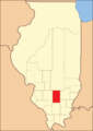
1821 to 1823

1823 until today


Demographic data
According to the 2010 census , Jefferson County had 38,827 people in 15,314 households. The population density was 26.3 inhabitants per square kilometer. Statistically, 2.41 people lived in each of the 15,314 households.
The racial the population was composed of 88.7 percent white, 8.7 percent African American, 0.3 percent Native American, 0.7 percent Asian and other ethnic groups; 1.6 percent were descended from two or more races. Regardless of ethnicity, 2.2 percent of the population was Hispanic or Latino of any race.
22.1 percent of the population were under 18 years old, 61.7 percent were between 18 and 64 and 16.2 percent were 65 years or older. 48.5 percent of the population was female.
The median income for a household was 42,679 USD . The per capita income was $ 22,032. 17.2 percent of the population lived below the poverty line.
Jefferson County localities
Other Unincorporated Communities
1 - partially in Washington , Clinton and Marion Counties
structure
Jefferson County is divided into 16 townships :
|
|
See also
Individual evidence
- ↑ GNIS-ID: 424242. Retrieved on February 22, 2011 (English).
- ↑ a b c U.S. Census Bureau, State & County QuickFacts - Jefferson County, IL ( Memento of the original from July 12, 2011 on WebCite ) Info: The archive link was automatically inserted and has not yet been checked. Please check the original and archive link according to the instructions and then remove this notice. Retrieved December 11, 2012
- ↑ a b National Association of Counties. Retrieved December 11, 2012
- ^ US Census Bureau - Census of Population and Housing.Retrieved March 15, 2011
- ^ Extract from Census.gov.Retrieved February 15, 2011
- ↑ Missouri Census Data Center - Illinois ( page no longer available , search in web archives ) Info: The link was automatically marked as defective. Please check the link according to the instructions and then remove this notice. Retrieved December 11, 2012
Web links
List of counties in Illinois
Adams |
Alexander |
Bond |
Boone |
Brown |
Bureau |
Calhoun |
Carroll |
Cass |
Champaign |
Christian |
Clark |
Clay |
Clinton |
Coles |
Cook |
Crawford |
Cumberland |
DeKalb |
DeWitt |
Douglas |
DuPage |
Edgar |
Edwards |
Effingham |
Fayette |
Ford |
Franklin |
Fulton |
Gallatin |
Greene |
Grundy |
Hamilton |
Hancock |
Hardin |
Henderson |
Henry |
Iroquois |
Jackson |
Jasper |
Jefferson |
Jersey |
Jo Daviess |
Johnson |
Kane |
Kankakee |
Kendall |
Knox |
LaSalle |
Lake |
Lawrence |
Lee |
Livingston |
Logan |
Macon |
Macoupin |
Madison |
Marion |
Marshall |
Mason |
Massac |
McDonough |
McHenry |
McLean |
Menard |
Mercer |
Monroe |
Montgomery |
Morgan |
Moultrie |
Ogle |
Peoria |
Perry |
Piatt |
Pike |
Pope |
Pulaski |
Putnam |
Randolph |
Richland |
Rock Island |
Saline |
Sangamon |
Schuyler |
Scott |
Shelby |
St. Clair |
Strong |
Stephenson |
Tazewell |
Union |
Vermilion |
Wabash |
Warren |
Washington |
Wayne |
White |
Whiteside |
Will |
Williamson |
Winnebago |
Woodford
Coordinates: 38 ° 18 ′ N , 88 ° 55 ′ W