
Vermilion County (Illinois)
 Vermilion County Courthouse |
|
| administration | |
|---|---|
| US state : | Illinois |
| Administrative headquarters : | Danville |
| Address of the administrative headquarters: |
Vermilion Courthouse Annex 6 North Vermilion Street Danville, Illinois 61832 |
| Foundation : | January 18, 1826 |
| Made up from: | Edgar County |
| Area code : | 001 217 |
| Demographics | |
| Residents : | 81,625 (2010 estimate) |
| Population density : | 35 inhabitants / km 2 |
| geography | |
| Total area : | 2337 km² |
| Water surface : | 8 km² |
| map | |
 |
|
| Website : www.co.vermilion.il.us | |
The Vermilion County is a county in eastern US -amerikanischen state of Illinois . In 2010 , the county had 81,625 residents and a population density of 35 people per square kilometer. The county seat is Danville .
geography
The county is located in eastern Illinois on the Indiana border . It has an area of 2337 square kilometers, of which eight square kilometers are water.
In the center the county is traversed by the Vermilion River ; the Little Vermilion River flows through the south . Both rivers flow into the Wabash River in neighboring Indiana .
The following neighboring counties border Vermilion County:
| Ford County | Iroquois County | Benton County, Indiana |
| Champaign County |
.svg)
|
Warren County, Indiana Vermillion County, Indiana |
| Douglas County | Edgar County |
Recreational areas
The county has 6 recreational areas or parks:
- Forest Glen Preserve (8 km northeast of Georgetown)
- Kennekuk Cove (11 km northwest of Danville)
- Lake Vermilion County Park
- Harry "Babe" Woodyard State Natural Area
- Middle Fork State Fish & Wildlife Area
- Kickapoo State Recreation Area
history
| Population development | |||
|---|---|---|---|
| Census | Residents | ± in% | |
| 1830 | 5836 | - | |
| 1840 | 9303 | 59.4% | |
| 1850 | 11,492 | 23.5% | |
| 1860 | 10,800 | -6% | |
| 1870 | 30,388 | 181.4% | |
| 1880 | 41,588 | 36.9% | |
| 1890 | 49.905 | 20% | |
| 1900 | 65,635 | 31.5% | |
| 1910 | 77.996 | 18.8% | |
| 1920 | 86,162 | 10.5% | |
| 1930 | 89,339 | 3.7% | |
| 1940 | 86,791 | -2.9% | |
| 1950 | 87,079 | 0.3% | |
| 1960 | 96.176 | 10.4% | |
| 1970 | 97.047 | 0.9% | |
| 1980 | 95,222 | -1.9% | |
| 1990 | 88,257 | -7.3% | |
| 2000 | 83,919 | -4.9% | |
| 2010 | 81,625 | -2.7% | |
| Before 1900 1900–1990 2000 2010 | |||
Vermilion County was formed from Edgar County on January 18, 1826. It was named after the Vermilion River that flows through the county.
Territorial development
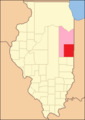
Vermilion County from its founding in 1826 to 1831
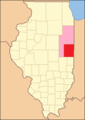
1831 to 1833

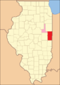
1833 to 1836

1836 to 1837

1837 to 1853
1853 to 1859

1859 until today


Demographic data
According to the 2010 census , Vermilion County's population was 81,625 in 31,979 households. The population density was 35 inhabitants per square kilometer. Statistically, 2.51 people lived in each of the 31,979 households.
The racial the population was composed of 83.6 percent white, 13.3 percent African American, 0.3 percent Native American, 0.8 percent Asian and other ethnic groups; 1.9 percent were descended from two or more races. Hispanic or Latino of any race was 4.4 percent of the population.
24.4 percent of the population were under 18 years old, 59.2 percent were between 18 and 64 and 16.4 percent were 65 years or older. 50.4 percent of the population was female.
The median income for a household was 40,463 USD . The per capita income was $ 21,000. 18.8 percent of the population lived below the poverty line.
Vermilion County localities
Other Unincorporated Communities
1 - partially in Champaign County
structure
Vermilion County is divided into 19 townships :
|
|
|

See also
Individual evidence
- ↑ GNIS-ID: 1785114. Retrieved on February 22, 2011 (English).
- ↑ a b c U.S. Census Bureau, State & County QuickFacts - Vermilion County, IL Retrieved January 15, 2013
- ↑ a b National Association of Counties.Retrieved January 15, 2013
- ↑ Photos. Retrieved January 15, 2013
- ↑ Photos. Retrieved January 15, 2013
- ↑ Photos. Retrieved January 15, 2013
- ↑ Photos. Retrieved January 15, 2013
- ^ US Census Bureau - Census of Population and Housing.Retrieved March 15, 2011
- ^ Extract from Census.gov.Retrieved February 15, 2011
- ↑ Missouri Census Data Center - Illinois ( page no longer available , search in web archives ) Info: The link was automatically marked as defective. Please check the link according to the instructions and then remove this notice. Retrieved January 15, 2013
Web links
- Official website
- www.city-data.com - Vermilion County, IL
- Illinois State Archives - Vermilion County
List of counties in Illinois
Adams |
Alexander |
Bond |
Boone |
Brown |
Bureau |
Calhoun |
Carroll |
Cass |
Champaign |
Christian |
Clark |
Clay |
Clinton |
Coles |
Cook |
Crawford |
Cumberland |
DeKalb |
DeWitt |
Douglas |
DuPage |
Edgar |
Edwards |
Effingham |
Fayette |
Ford |
Franklin |
Fulton |
Gallatin |
Greene |
Grundy |
Hamilton |
Hancock |
Hardin |
Henderson |
Henry |
Iroquois |
Jackson |
Jasper |
Jefferson |
Jersey |
Jo Daviess |
Johnson |
Kane |
Kankakee |
Kendall |
Knox |
LaSalle |
Lake |
Lawrence |
Lee |
Livingston |
Logan |
Macon |
Macoupin |
Madison |
Marion |
Marshall |
Mason |
Massac |
McDonough |
McHenry |
McLean |
Menard |
Mercer |
Monroe |
Montgomery |
Morgan |
Moultrie |
Ogle |
Peoria |
Perry |
Piatt |
Pike |
Pope |
Pulaski |
Putnam |
Randolph |
Richland |
Rock Island |
Saline |
Sangamon |
Schuyler |
Scott |
Shelby |
St. Clair |
Strong |
Stephenson |
Tazewell |
Union |
Vermilion |
Wabash |
Warren |
Washington |
Wayne |
White |
Whiteside |
Will |
Williamson |
Winnebago |
Woodford
Coordinates: 40 ° 11 ′ N , 87 ° 44 ′ W