
Schuyler County, Illinois
 Schuyler County Courthouse |
|
| administration | |
|---|---|
| US state : | Illinois |
| Administrative headquarters : | Rushville |
| Address of the administrative headquarters: |
County Courthouse P.O. Box 200 Rushville, IL 62681-0200 |
| Foundation : | January 13, 1825 |
| Made up from: | Pike County |
| Area code : | 001 217 |
| Demographics | |
| Residents : | 7544 (2010) |
| Population density : | 6.7 inhabitants / km 2 |
| geography | |
| Total area : | 1143 km² |
| Water surface : | 11 km² |
| map | |
 |
|
| Website : www.schuylercountyillinois.com | |
The Schuyler County is a county in the US -amerikanischen State Illinois . In 2010 , the county had 7,544 residents and a population density of 6.7 people per square kilometer. The county seat is Rushville .
geography
The county is located in western Illinois on the right bank of the Illinois River , about 50 km east of the Mississippi , which forms the border with Missouri and Iowa . It has an area of 1143 square kilometers, of which eleven square kilometers are water. The following neighboring counties border Schuyler County:
| Hancock County | McDonough County | Fulton County |
.svg)
|
Mason County | |
| Adams County | Brown County | Cass County |
history

| Population development | |||
|---|---|---|---|
| Census | Residents | ± in% | |
| 1830 | 2959 | - | |
| 1840 | 6972 | 135.6% | |
| 1850 | 10,573 | 51.6% | |
| 1860 | 14,684 | 38.9% | |
| 1870 | 17,419 | 18.6% | |
| 1880 | 16,249 | -6.7% | |
| 1890 | 16,013 | -1.5% | |
| 1900 | 16,129 | 0.7% | |
| 1910 | 14,852 | -7.9% | |
| 1920 | 13,285 | -10.6% | |
| 1930 | 11,676 | -12.1% | |
| 1940 | 11,430 | -2.1% | |
| 1950 | 9613 | -15.9% | |
| 1960 | 8746 | -9% | |
| 1970 | 8135 | -7% | |
| 1980 | 8365 | 2.8% | |
| 1990 | 7498 | -10.4% | |
| 2000 | 7189 | -4.1% | |
| 2010 | 7544 | 4.9% | |
| Before 1900 1900–1990 2000 2010 | |||
Schuyler County was formed on January 13, 1825 as the 31st County in Illinois from parts of Pike County . It was named after Philip Schuyler , a general in the American Revolutionary War and US Senator from New York .
In 1826, Rushville was chosen as the administrative seat after 20 rounds of voting. The first courthouse was built in the same year. On January 18, 1827, the county received the first postal office. The former prison now serves as a museum.
Territorial development
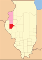
Schuyler County from its founding in 1825 to 1826

1826 to 1830
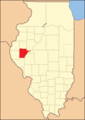
1830 to 1839

1839 until today


Demographic data
According to the 2010 census , there were 7,544 people in 3,081 households in Schuyler County. The population density was 6.7 people per square kilometer. Statistically, 2.38 people lived in 3081 households.
The racial the population was composed of 95.6 percent white, 3.2 percent African American, 0.2 percent Native American, 0.3 percent Asian and other ethnic groups; 0.5 percent were descended from two or more races. Hispanic or Latino of any race was 1.6 percent of the population.
20.8 percent of the population were under 18 years old, 60.7 percent were between 18 and 64 and 18.5 percent were 65 years or older. 47.5 percent of the population was female.
The median income for a household was 22,215 USD . The per capita income was $ 43,902. 15.2 percent of the population lived below the poverty line.
Localities in Schuyler County
structure
Schuyler County is divided into 13 townships :
|
|
See also
Individual evidence
- ↑ GNIS-ID: 1785037. Retrieved on February 22, 2011 (English).
- ↑ a b c U.S. Census Bureau, State & County QuickFacts - Schuyler County, IL Retrieved January 9, 2013
- ↑ a b National Association of Counties.Retrieved January 9, 2013
- ^ US Census Bureau - Census of Population and Housing.Retrieved March 15, 2011
- ^ Extract from Census.gov.Retrieved February 15, 2011
- ↑ Missouri Census Data Center - Illinois ( page no longer available , search in web archives ) Info: The link was automatically marked as defective. Please check the link according to the instructions and then remove this notice. Retrieved January 9, 2013
Web links
List of counties in Illinois
Adams |
Alexander |
Bond |
Boone |
Brown |
Bureau |
Calhoun |
Carroll |
Cass |
Champaign |
Christian |
Clark |
Clay |
Clinton |
Coles |
Cook |
Crawford |
Cumberland |
DeKalb |
DeWitt |
Douglas |
DuPage |
Edgar |
Edwards |
Effingham |
Fayette |
Ford |
Franklin |
Fulton |
Gallatin |
Greene |
Grundy |
Hamilton |
Hancock |
Hardin |
Henderson |
Henry |
Iroquois |
Jackson |
Jasper |
Jefferson |
Jersey |
Jo Daviess |
Johnson |
Kane |
Kankakee |
Kendall |
Knox |
LaSalle |
Lake |
Lawrence |
Lee |
Livingston |
Logan |
Macon |
Macoupin |
Madison |
Marion |
Marshall |
Mason |
Massac |
McDonough |
McHenry |
McLean |
Menard |
Mercer |
Monroe |
Montgomery |
Morgan |
Moultrie |
Ogle |
Peoria |
Perry |
Piatt |
Pike |
Pope |
Pulaski |
Putnam |
Randolph |
Richland |
Rock Island |
Saline |
Sangamon |
Schuyler |
Scott |
Shelby |
St. Clair |
Strong |
Stephenson |
Tazewell |
Union |
Vermilion |
Wabash |
Warren |
Washington |
Wayne |
White |
Whiteside |
Will |
Williamson |
Winnebago |
Woodford
Coordinates: 40 ° 10 ′ N , 90 ° 37 ′ W