
McCracken County
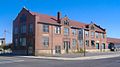
 McCracken County Courthouse |
|
| administration | |
|---|---|
| US state : | Kentucky |
| Administrative headquarters : | Paducah |
| Address of the administrative headquarters: |
County Courthouse 301 South 6th Street Paducah, KY 42003-1702 |
| Foundation : | December 17, 1824 |
| Made up from: | Hickman County |
| Area code : | 001 270 |
| Demographics | |
| Residents : | 65,565 (2010) |
| Population density : | 100.9 inhabitants / km 2 |
| geography | |
| Total area : | 694 km² |
| Water surface : | 44 km² |
| map | |
 |
|
The McCracken County is a county in the US -amerikanischen State Kentucky . In 2010 the county had 65,565 people and a population density of 100.9 people per square kilometer. The county seat is Paducah , which was named after a Chickasaw chief .
geography
The county is located at the confluence of the Tennessee River with the Ohio in southwest Kentucky. The northern border to Illinois is formed by the Ohio. McCracken County covers an area of 694 square kilometers, of which 44 square kilometers are water. The following neighboring counties border McCracken County:
|
Massac County (Illinois) |
Livingston County | |
| Ballard County |
.svg)
|
Marshall County |
| Carlisle County | Graves County |
history
| Population development | |||
|---|---|---|---|
| Census | Residents | ± in% | |
| 1830 | 1297 | - | |
| 1840 | 4745 | 265.8% | |
| 1850 | 6067 | 27.9% | |
| 1860 | 10,360 | 70.8% | |
| 1870 | 13,988 | 35% | |
| 1880 | 16,262 | 16.3% | |
| 1890 | 21,051 | 29.4% | |
| 1900 | 28,733 | 36.5% | |
| 1910 | 35,064 | 22% | |
| 1920 | 37,246 | 6.2% | |
| 1930 | 46.271 | 24.2% | |
| 1940 | 48,534 | 4.9% | |
| 1950 | 49,137 | 1.2% | |
| 1960 | 57,306 | 16.6% | |
| 1970 | 58,281 | 1.7% | |
| 1980 | 61,310 | 5.2% | |
| 1990 | 62,879 | 2.6% | |
| 2000 | 65,514 | 4.2% | |
| 2010 | 65,565 | 0.1% | |
| Before 1900 1900-2000 2010 | |||
McCracken County was formed on December 17, 1824 from parts of Hickman County. It was named after Captain Virgil McCracken , who was killed in the Battle of Frenchtown in 1813 .
During the civil war , a battle between the Union troops and the Confederate troops took place here, near Paducah, on March 25, 1864, and they were victorious. A total of 140 men were killed in this battle.
Historical objects

Confederate Monument in Paducah, listed in the NRHP since 1997

Lloyd Tilghman Memorial in Paducah, listed in the NRHP since 1997

Anderson-Smith House in Paducah, listed in the NRHP since 1984
Paducah Railroad Station , listed on the NRHP since 1979


further objects:
Demographic data
According to the 2010 census , McCracken County had 65,565 people in 28,159 households. The population density was 100.9 inhabitants per square kilometer.
The racial the population was composed of 85.0 percent white, 11.0 percent African American, 0.2 percent Native American, 0.8 percent Asian and other ethnic groups; 2.1 percent were descended from two or more races. Hispanic or Latino of any race was 2.1 percent of the population.
Statistically, 2.27 people lived in each of the 28,159 households.
22.4 percent of the population were under 18 years old, 60.8 percent were between 18 and 64 and 16.8 percent were 65 years or older. 52.0 percent of the population was female.
The median income for a household was 40,976 USD . The per capita income was $ 24,463. 15.5 percent of the population lived below the poverty line
cities and communes
Census-designated places (CDP)
1 - partially in Graves County
structure
McCracken County is divided into four Census County Divisions (CCD):
| CCD | Population (2010) | FIPS |
|---|---|---|
| Camelia CCD | 2892 | 21-90516 |
| Grahamville-Heath CCD | 6328 | 21-91436 |
| Paducah CCD | 51,458 | 21-92648 |
| St. Johns-Freemont CCD | 4887 | 21-93028 |
Individual evidence
- ^ McCracken County ( English ) In: Geographic Names Information System . United States Geological Survey . Retrieved February 22, 2011.
- ↑ a b c U.S. Census Bureau, State & County QuickFacts - McCracken County, KY Retrieved September 8, 2012
- ^ National Association of Counties.Retrieved December 23, 2011
- ^ US Census Bureau _ Census of Population and Housing.Retrieved February 18, 2011
- ^ Extract from Census.gov.Retrieved February 18, 2011
- ↑ Extract from the National Register of Historic Places - No. 97000678.Retrieved December 23, 2011
- ↑ Extract from the National Register of Historic Places - No. 97000679.Retrieved December 23, 2011
- ↑ Extract from the National Register of Historic Places - No. 84001824.Retrieved December 23, 2011
- ↑ Extract from the National Register of Historic Places - No. 79003118.Retrieved December 23, 2011
- ↑ Missouri Census Data Center - Kentucky ( page no longer available , search in web archives ) Info: The link was automatically marked as defective. Please check the link according to the instructions and then remove this notice. Retrieved September 8, 2012
Web links
List of counties in Kentucky
Adair |
Allen |
Anderson |
Ballard |
Bars |
Bath |
Bell |
Boone |
Bourbon |
Boyd |
Boyle |
Bracken |
Breathitt |
Breckinridge |
Bullitt |
Butler |
Caldwell |
Calloway |
Campbell |
Carlisle |
Carroll |
Carter |
Casey |
Christian |
Clark |
Clay |
Clinton |
Crittenden |
Cumberland |
Daviess |
Edmonson |
Elliott |
Estill |
Fayette |
Fleming |
Floyd |
Franklin |
Fulton |
Gallatin |
Garrard |
Grant |
Graves |
Grayson |
Green |
Greenup |
Hancock |
Hardin |
Harlan |
Harrison |
Hard |
Henderson |
Henry |
Hickman |
Hopkins |
Jackson |
Jefferson |
Jessamine |
Johnson |
Kenton |
Knott |
Knox |
LaRue |
Laurel |
Lawrence |
Lee |
Leslie |
Letcher |
Lewis |
Lincoln |
Livingston |
Logan |
Lyon |
Madison |
Magoffin |
Marion |
Marshall |
Martin |
Mason |
McCracken |
McCreary |
McLean |
Meade |
Menifee |
Mercer |
Metcalfe |
Monroe |
Montgomery |
Morgan |
Muhlenberg |
Nelson |
Nicholas |
Ohio |
Oldham |
Owen |
Owsley |
Pendleton |
Perry |
Pike |
Powell |
Pulaski |
Robertson |
Rockcastle |
Rowan |
Russell |
Scott |
Shelby |
Simpson |
Spencer |
Taylor |
Todd |
Trigg |
Trimble |
Union |
Warren |
Washington |
Wayne |
Webster |
Whitley |
Wolfe |
Woodford
Coordinates: 37 ° 4 ′ N , 88 ° 43 ′ W