Leslie County
 Leslie County Courthouse |
|
| administration | |
|---|---|
| US state : | Kentucky |
| Administrative headquarters : | Hyden |
| Address of the administrative headquarters: |
County Courthouse P.O. Box 619 Hyden, KY 41749-0619 |
| Foundation : | March 29, 1878 |
| Made up from: |
Clay County Harlan County Perry County |
| Area code : | 001 606 |
| Demographics | |
| Residents : | 11,310 (2010) |
| Population density : | 10.8 inhabitants / km 2 |
| geography | |
| Total area : | 1047 km² |
| Water surface : | 1 km² |
| map | |
| Website : www.lesliecounty.net | |
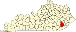
Leslie County is a county in the state of Kentucky in the United States . The county seat is Hyden , named after John Hyden , a Kentucky Senator. The county is part of the dry counties , which means that the sale of alcohol is restricted or prohibited.
geography
The county is located in southeast Kentucky, about 60 km from Tennessee to the southwest , about 30 km to the southeast from Virginia , and covers an area of 1,047 square kilometers, one square kilometer of which is water. It is bordered clockwise by the following counties: Perry County , Harlan County , Bell County, and Clay Counties .
history
Leslie County was formed on March 29, 1878 from parts of Clay County, Harlan County and Perry County. It was named after the governor Preston H. Leslie .
A building in Leslie County has the status of a National Historic Landmark , the Wendover , because of its special historical significance . A total of five buildings and sites in the county are listed on the National Register of Historic Places (as of October 9, 2017).
Demographic data
| growth of population | |||
|---|---|---|---|
| Census | Residents | ± in% | |
| 1880 | 3740 | - | |
| 1890 | 3964 | 6% | |
| 1900 | 6753 | 70.4% | |
| 1910 | 8976 | 32.9% | |
| 1920 | 10.097 | 12.5% | |
| 1930 | 10,765 | 6.6% | |
| 1940 | 14,981 | 39.2% | |
| 1950 | 15,537 | 3.7% | |
| 1960 | 10,941 | -29.6% | |
| 1970 | 11,623 | 6.2% | |
| 1980 | 14,882 | 28% | |
| 1990 | 13,642 | -8.3% | |
| 2000 | 12,401 | -9.1% | |
| 2010 | 11,310 | -8.8% | |
| Before 1900
1900–1990 2000 + 2010 |
|||
As of the 2000 census , Leslie County had 12,401 people. Of these, 110 people lived in collective accommodation, the other residents lived in 4,885 households and 3,668 families. The population density was 12 people per square kilometer. The racial the population was composed of 99.15 percent white, 0.07 percent African American, 0.09 percent Native American, 0.12 percent Asian, 0.02 percent of residents from the Pacific island area and 0.05 percent from other ethnic groups Groups; 0.50 percent were descended from two or more races. Hispanic or Latino of any race was 0.62 percent of the population.
Of the 4,885 households, 35.5 percent had children and adolescents under the age of 18 living with them. 58.3 percent were married couples living together, 12.9 percent were single mothers, 24.9 percent were non-families, 22.4 percent were single households and 8.7 percent had people aged 65 years or over. The average household size was 2.52 and the average family size was 2.94.
For the entire county, the population was composed of 24.6 percent of residents under 18 years of age, 9.2 percent between 18 and 24 years of age, 30.9 percent between 25 and 44 years of age, and 23.9 percent between 45 and 64 years of age 11.5 percent were 65 years of age or over. The median age was 36 years. For every 100 females there were 95.1 males. For every 100 women 18 years of age or older there were statistically 91.2 men.
The median income for a household in the county is $ 18,546 , and the median income for a family is $ 22,225. Males had a median income of $ 28,708 versus $ 18,080 for females. The per capita income was $ 10,429. 30.2 percent of families and 32.7 percent of the population were below the poverty line. Of these, 38.8 percent were children or adolescents under 18 years of age and 27.0 percent were people over 65 years of age.
Places in the county
Web links
Individual evidence
- ↑ GNIS-ID: 516912. Retrieved on February 22, 2011 (English).
- ↑ Listing of National Historic Landmarks by State: Kentucky . National Park Service , accessed October 9, 2017.
- ↑ Search mask database in the National Register Information System. National Park Service , accessed October 9, 2017.
- ^ US Census Bureau _ Census of Population and Housing . Retrieved February 18, 2011
- ↑ Extract from Census.gov . Retrieved February 18, 2011
- ↑ Extract from census.gov (2000 + 2010) ( Memento of the original from July 13, 2011 on WebCite ) Info: The archive link was automatically inserted and not yet checked. Please check the original and archive link according to the instructions and then remove this notice. Retrieved April 2, 2012
- ^ Leslie County, Kentucky , 2000 census data sheet at factfinder.census.gov .
Coordinates: 37 ° 5 ′ N , 83 ° 23 ′ W
