St. Louis County, Missouri
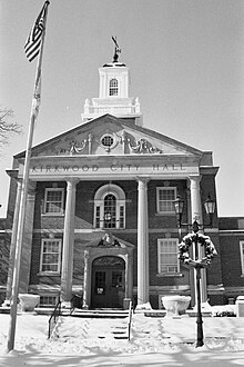
 St. Louis County Courthouse |
|
| administration | |
|---|---|
| US state : | Missouri |
| Administrative headquarters : | Clayton |
| Address of the administrative headquarters: |
County Courthouse 41 South Central Avenue Clayton, MO 63105-1719 |
| Foundation : | 1812 |
| Area code : | 001 314 |
| Demographics | |
| Residents : | 998,954 (2010) |
| Population density : | 759.7 inhabitants / km 2 |
| geography | |
| Total area : | 1356 km² |
| Water surface : | 41 km² |
| map | |
| Website : www.stlouisco.com | |
The St. Louis County is a county in the US -amerikanischen State Missouri . In 2010 , the county had 998,954 residents and a population density of 759.7 people per square kilometer. The county seat is Clayton , named after Ralph Clayton , a farmer who donated land to the city.
St. Louis County is part of the Greater St. Louis Metropolitan Area .
geography
The county is located in the far east of Missouri at the confluence of the Missouri and the Mississippi . St. Louis County encloses the urban area of St. Louis , borders Illinois , from which it is separated by the Mississippi, and has an area of 1,356 square kilometers, of which 41 square kilometers are water. It borders on the following counties:
| St. Charles County |
Madison County (Illinois) |
|

|
St. Louis | |
| Franklin County |
Jefferson County |
St. Clair County, Illinois , Monroe County, Illinois |
history
St. Louis County was formed in 1812 and was previously a Spanish district named after King Louis of France. In 1876 the city of St. Louis split from the county and became a separate, independent urban area.
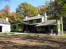
In St. Louis County is the Ulysses S. Grant National Historic Site , also known as White Haven. This National Historic Site also has the status of a National Historic Landmark . 587 buildings and sites in the county are listed on the National Register of Historic Places (NRHP) (as of September 21, 2018).
Demographic data
| Population development | |||
|---|---|---|---|
| Census | Residents | ± in% | |
| 1810 | 5667 | - | |
| 1820 | 10,020 | 76.8% | |
| 1830 | 14,125 | 41% | |
| 1840 | 35,970 | 154.7% | |
| 1850 | 104,978 | 191.8% | |
| 1860 | 190,524 | 81.5% | |
| 1870 | 351.189 | 84.3% | |
| 1880 | 31,888 | -90.9% | |
| 1890 | 36,307 | 13.9% | |
| 1900 | 50,040 | 37.8% | |
| 1910 | 82,417 | 64.7% | |
| 1920 | 100,737 | 22.2% | |
| 1930 | 211,593 | 110% | |
| 1940 | 274.230 | 29.6% | |
| 1950 | 406.349 | 48.2% | |
| 1960 | 703.532 | 73.1% | |
| 1970 | 951.353 | 35.2% | |
| 1980 | 973.896 | 2.4% | |
| 1990 | 993.529 | 2% | |
| 2000 | 1,016,315 | 2.3% | |
| 2010 | 998.954 | -1.7% | |
| Before 1900 1900–1990 2000–2010 | |||
According to the 2010 census , St. Louis County had 998,954 people in 403,699 households. The population density was 759.7 people per square kilometer.
The racial the population was composed of 70.3 percent white, 23.3 percent African American, 0.2 percent Native American, 3.5 percent Asian and other ethnic groups; 1.9 percent were descended from two or more races. Regardless of ethnicity, 2.5 percent of the population was Hispanic or Latino of any race.
Statistically, 2.40 people lived in each of the 403,699 households.
23.4 percent of the population were under 18 years old, 61.6 percent were between 18 and 64 and 15.0 percent were 65 years or older. 52.7 percent of the population was female.
The median income for a household was 56.939 USD . The per capita income was $ 33,236. 9.6 percent of the population lived below the poverty line.
Places in St. Louis County
Census-designated places (CDP)
1 - partially in Franklin County
structure
St. Louis County is divided into 28 townships :
|
|
|
See also
Individual evidence
- ↑ GNIS-ID: 758549. Retrieved on February 22, 2011 (English).
- ↑ a b c U.S. Census Bureau, State & County QuickFacts - St. Louis County, MO. Retrieved April 21, 2012
- ^ National Association of Counties.Retrieved November 24, 2011
- ↑ Listing of National Historic Landmarks by State: Missouri . National Park Service , accessed February 6, 2018.
- ↑ Search mask database in the National Register Information System. National Park Service , accessed September 21, 2018.
- ↑ US Census Bureau - Census of Population and Housing.Retrieved November 24, 2014
- ^ Extract from Census.gov.Retrieved February 18, 2011
- ↑ Missouri Census Data Center. Retrieved June 23, 2012
Web links
Coordinates: 38 ° 38 ′ N , 90 ° 26 ′ W


