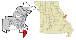
Oakville, Missouri
| Oakville | |
|---|---|
|
Location in Missouri
|
|
| Basic data | |
| State : | United States |
| State : | Missouri |
| County : | St. Louis County |
| Coordinates : | 38 ° 28 ′ N , 90 ° 18 ′ W |
| Time zone : | Central ( UTC − 6 / −5 ) |
| Residents : | 36,143 (as of 2010) |
| Population density : | 868.8 inhabitants per km 2 |
| Area : | 46.8 km 2 (approx. 18 mi 2 ) of which 41.6 km 2 (approx. 16 mi 2 ) is land |
| Height : | 183 m |
| Postal code : | 63129 |
| Area code : | +1 314 |
| FIPS : | 29-53876 |
| GNIS ID : | 756472 |
| Website : | www.oakvillemo.org |
Oakville is a community-free settlement that is listed as a census-designated place (CDP) for statistical purposes . Oakville is located in St. Louis County in the US -amerikanischen State Missouri and is part of the metropolitan region Greater St. Louis . In 2010 , Oakville had 36,143 residents.
geography
Oakville is located in the southwestern suburb of St. Louis , about a kilometer above the confluence of the Meramec River in the Mississippi , which forms the border with Illinois . Oakville is located at 38 ° 28'12 "north latitude and 90 ° 18'16" west longitude. Oakville extends over 46.8 km², which is spread over 41.6 km² of land and 5.2 km² of water.
Oakville is located in the Oakville Township , the territory of which consists largely of the town.
Neighboring places to Oakville are Mehlville (3.5 miles north), Columbia on the opposite bank of the Mississippi in Illinois (14.3 miles east), Imperial (9.7 miles southwest), and Arnold ( 6 miles southwest). The center of the city of St. Louis is 14 miles northeast.
traffic
Missouri State Route 231 runs through Oakville along the Mississippi . All other roads are county roads or subordinate inner-city connecting roads.
A railway line runs along the Mississippi, operated by the Union Pacific Railroad , the BNSF Railway and Amtrak .
The Lambert-Saint Louis International Airport is located 45.4 km north of Oakville.
Demographic data
According to the 2010 census , Oakville had 36,143 people in 13,788 households. The population density was 868.8 people per square kilometer. Statistically, there were 2.61 people each in the 13,788 households.
The racial the population was composed of 96.0 percent white, 0.8 percent African American, 0.1 percent Native American, 1.8 percent Asian and 0.3 percent from other ethnic groups; 1.0 percent were descended from two or more races. Hispanic or Latino of any race was 1.4 percent of the population.
22.8 percent of the population were under 18 years old, 62.9 percent were between 18 and 64 and 14.3 percent were 65 years or older. 51.0 percent of the population was female.
The average annual income for a household was 77,128 USD . The per capita income was $ 35,176. 1.8 percent of the population lived below the poverty line.
Personalities
- Bridgett Riley (* 1973), stunt woman and actress
- David McIntyre (born 1987), ice hockey player
Individual evidence
- ↑ a b American Fact Finder. Retrieved June 25, 2012
- ↑ Distance information according to Google Maps. Accessed June 25, 2012
