Clayton (Missouri)
| Clayton | |
|---|---|
|
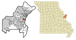
Location in Missouri
|
|
| Basic data | |
| Foundation : | 1877 |
| State : | United States |
| State : | Missouri |
| County : | St. Louis County |
| Coordinates : | 38 ° 39 ′ N , 90 ° 20 ′ W |
| Time zone : | Central ( UTC − 6 / −5 ) |
| Residents : | 16,061 (as of 2006) |
| Population density : | 2,509.5 inhabitants per km 2 |
| Area : | 6.4 km 2 (approx. 2 mi 2 ) of which 6.4 km 2 (approx. 2 mi 2 ) is land |
| Height : | 173 m |
| Postal code : | 63105 |
| Area code : | +1 314 |
| FIPS : | 29-14572 |
| GNIS ID : | 0755896 |
| Website : | www.ci.clayton.mo.us |
| Mayor : | Linda Goldstein |
Clayton is a city and county seat in St. Louis County , Missouri , United States . It is also a suburb of St. Louis .
Demographics and data
According to the 2000 census, 12,825 people, spread over 6.4 km², live in Clayton. This results in a population density of 2000 inhabitants / km². The founding of the city by its namesake Ralph Clayton can be dated back to 1877.
84.9% of the residents are white, 7.7% African-American and third place is Asian with 5.6%. 30.8% of them are 24 years old or younger, only 14.3% are 65 years old or older; the average age is 37 years.
The average annual income for a household is $ 64,184; 7.7% of Clayton's residents live below the poverty line.
sons and daughters of the town
- James Franciscus , film actor
- Samuel Pearson Goddard Jr. , Governor of Arizona
- Bob Gamm , founder of KangaRoos
- Ernest Trova , painter and sculptor
