Des Peres
| Des Peres | |
|---|---|
 Town Hall of Des Peres |
|
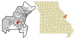
| Des Peres in St. Louis County | |
| Basic data | |
| State : | United States |
| State : | Missouri |
| County : | St. Louis County |
| Coordinates : | 38 ° 36 ′ N , 90 ° 27 ′ W |
| Time zone : | Central ( UTC − 6 / −5 ) |
| Residents : | 8,373 (as of 2010) |
| Population density : | 748.3 inhabitants per km 2 |
| Area : | 11.19 km 2 (approx. 4 mi 2 ) of which 11.19 km 2 (approx. 4 mi 2 ) is land |
| Height : | 186 m |
| FIPS : | 29-19270 |
| GNIS ID : | 0755986 |
| Website : | www.desperesmo.org |
Des Peres ( French : Des Pères ) is a city in St. Louis County in the US state of Missouri . In 2010 Des Peres had 8373 inhabitants.
geography
The coordinates of Des Peres are 38 ° 35'46 "north latitude and 90 ° 26'50" west longitude. According to the 2010 United States Census , the urban area of Des Peres covers an area of 11.19 square kilometers (4.32 sq mi).
population
According to the United States Census 2010 , 8,373 people lived in Des Peres in 3,051 households and 2,474 families. The population density was 748.3 people per square kilometer (1938.2 / sq mi).
The 2010 population was composed of 94.3% White, 0.9% African American, 3.1% Asian, 0.2% Native American, 0.3% from other races, and 1.2% from two or more races from. There were people under the age of 18 in 35.3% of households and people who were 65 years of age or older lived in 7.8%. The median age was 45.9 years and 48.5% of the population were male.
