Carroll County, Missouri
![The Carroll County Courthouse in Carrollton, listed on NRHP No. 95000858 [1]](https://upload.wikimedia.org/wikipedia/commons/thumb/4/44/Carroll-ch.jpg/298px-Carroll-ch.jpg) The Carroll County Courthouse in Carrollton, listed on NRHP No. 95000858 |
|
| administration | |
|---|---|
| US state : | Missouri |
| Administrative headquarters : | Carrollton |
| Address of the administrative headquarters: |
County Courthouse 8 S. Main Carrollton, MO 64633-1680 |
| Foundation : | January 2, 1833 |
| Made up from: | Ray County |
| Area code : | 001 660 |
| Demographics | |
| Residents : | 9295 (2010) |
| Population density : | 5.2 inhabitants / km 2 |
| geography | |
| Total area : | 1819 km² |
| Water surface : | 20 km² |
| map | |
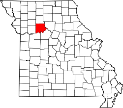
The Carroll County is a county in the US -amerikanischen State Missouri . In 2010 , the county had 9,295 residents and a population density of 5.2 people per square kilometer. The county seat is Carrollton .
geography
The county is located in central northwest Missouri on the north bank of the Missouri River west of the confluence of the Grand River . It has an area of 1819 square kilometers, of which 20 square kilometers are water. The following neighboring counties border Carroll County:
| Caldwell County | Livingston County | |
| Ray County |

|
Chariton County |
| Lafayette County | Saline County |
history
Carroll County was formed on January 2, 1833 from parts of Ray County. It was named, like the city of Carrollton, after Charles Carroll (1737-1832), one of the founding fathers and co-signer of the United States' Declaration of Independence .
Demographic data
| Population development | |||
|---|---|---|---|
| Census | Residents | ± in% | |
| 1840 | 2423 | - | |
| 1850 | 5441 | 124.6% | |
| 1860 | 9763 | 79.4% | |
| 1870 | 17,446 | 78.7% | |
| 1880 | 23,274 | 33.4% | |
| 1890 | 25,742 | 10.6% | |
| 1900 | 26,455 | 2.8% | |
| 1910 | 23,098 | -12.7% | |
| 1920 | 20,480 | -11.3% | |
| 1930 | 19,940 | -2.6% | |
| 1940 | 17,814 | -10.7% | |
| 1950 | 15,589 | -12.5% | |
| 1960 | 13,847 | -11.2% | |
| 1970 | 12,565 | -9.3% | |
| 1980 | 12,131 | -3.5% | |
| 1990 | 10,748 | -11.4% | |
| 2000 | 10,285 | -4.3% | |
| 2010 | 9295 | -9.6% | |
| Before 1900 1900–1990 2000 2010 | |||
According to the 2010 census , Carroll County had 9,295 people in 4,156 households. The population density was 5.2 inhabitants per square kilometer. Statistically, 2.36 people lived in the 4,156 households.
The racial the population was composed of 96.6 percent white, 1.7 percent African American, 0.2 percent Native American, 0.1 percent Asian and other ethnic groups; 1.1 percent were descended from two or more races. Hispanic or Latino of any race was 1.3 percent of the population, regardless of ethnicity.
23.6 percent of the population were under 18 years old, 57.3 percent were between 18 and 64 and 19.1 percent were 65 years or older. 51.2 percent of the population was female.
The median income for a household was 40,912 USD . The per capita income was $ 23,887. 15.3 percent of the population lived below the poverty line.
Places in Carroll County
|
|
structure
Carroll County is divided into 20 townships :
|
|
See also
Web links
Individual evidence
- ^ Extract from the National Register of Historic Places.Retrieved March 13, 2011
- ↑ GNIS-ID: 758471. Retrieved on February 22, 2011 (English).
- ↑ a b c U.S. Census Bureau, State & County QuickFacts - Carroll County, MO. Retrieved October 18, 2012
- ^ A b National Association of Counties.Retrieved October 18, 2012
- ^ US Census Bureau - Census of Population and Housing.Retrieved March 15, 2011
- ↑ Extract from Census.gov . Retrieved February 18, 2011
- ↑ Missouri Census Data Center ( page no longer available , search in web archives ) Info: The link was automatically marked as defective. Please check the link according to the instructions and then remove this notice. Retrieved October 18, 2012
Coordinates: 39 ° 26 ′ N , 93 ° 30 ′ W

