Boone County, Missouri
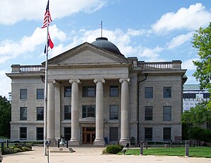
 The Boone County Courthouse in Columbia |
|
| administration | |
|---|---|
| US state : | Missouri |
| Administrative headquarters : | Columbia |
| Address of the administrative headquarters: |
County Government Center 801 East Walnut Columbia, MO 65201 |
| Foundation : | November 16, 1820 |
| Made up from: | Howard County |
| Area code : | 001 573 |
| Demographics | |
| Residents : | 162,642 (2010) |
| Population density : | 91.6 inhabitants / km 2 |
| geography | |
| Total area : | 1790 km² |
| Water surface : | 15 km² |
| map | |
The Boone County is a county in the US -amerikanischen State Missouri . In 2010 , the county had 162,642 residents and a population density of 91.6 people per square kilometer. The county seat is Columbia , where several well-known coffee companies are based.
geography
The county is located on the left bank of the Missouri River just north of the geographic center of the state of Missouri. It has an area of 1790 square kilometers, of which 15 square kilometers are water. The following neighboring counties border Boone County:
| Howard County | Randolph County | Audrain County |
| Cooper County |

|
Callaway County |
| Moniteau County | Cole County |
history
Boone County was formed on November 16, 1820 from parts of Howard County. It was named after Daniel Boone , a US pioneer and border guard who opened up the so-called Wilderness Trail and founded the town of Boonesborough in Kentucky .
One place has the status of a National Historic Landmark , the Sanborn Field . 51 buildings and sites in the county are registered in the National Register of Historic Places (as of February 5, 2018).
Demographic data
| Population development | |||
|---|---|---|---|
| Census | Residents | ± in% | |
| 1830 | 8859 | - | |
| 1840 | 13,561 | 53.1% | |
| 1850 | 14,979 | 10.5% | |
| 1860 | 19,486 | 30.1% | |
| 1870 | 20,765 | 6.6% | |
| 1880 | 25,422 | 22.4% | |
| 1890 | 26,043 | 2.4% | |
| 1900 | 28,642 | 10% | |
| 1910 | 30,533 | 6.6% | |
| 1920 | 29,672 | -2.8% | |
| 1930 | 30,995 | 4.5% | |
| 1940 | 34,991 | 12.9% | |
| 1950 | 48,432 | 38.4% | |
| 1960 | 55.202 | 14% | |
| 1970 | 80,911 | 46.6% | |
| 1980 | 100,376 | 24.1% | |
| 1990 | 112,379 | 12% | |
| 2000 | 135,454 | 20.5% | |
| 2010 | 162,642 | 20.1% | |
| Before 1900 1900–1990 2000 2010 | |||
According to the 2010 census , Boone County had 162,642 people in 63,622 households. The population density was 91.6 inhabitants per square kilometer. Statistically, 2.25 people lived in each of the 63,622 households.
The racial the population was composed of 82.8 percent white, 9.3 percent African American, 0.4 percent Native American, 3.8 percent Asian and other ethnic groups; 2.8 percent were descended from two or more races. Hispanic or Latino of any race was 3.0 percent of the population.
21.1 percent of the population were under 18 years old, 69.6 percent were between 18 and 64 and 9.3 percent were 65 years or older. 51.5 percent of the population was female.
The median income for a household was 46,439 USD . The per capita income was $ 24,843. 17.8 percent of the population lived below the poverty line.
Localities in Boone County
|
|
|
1 - partially in Audrain County
structure
Boone County is divided into ten townships :
| Township | Population (2010) |
FIPS |
|---|---|---|
| Bourbon Township | 2729 | 29-07498 |
| Cedar Township | 4190 | 29-12142 |
| Centralia Township | 4906 | 29-12916 |
| Columbia Township | 62,961 | 29-15688 |
| Katy Township | 3787 | 29-38045 |
| Missouri Township | 58.199 | 29-48944 |
| Perche Township | 4079 | 29-57026 |
| Rock Bridge Township | 8261 | 29-62592 |
| Rocky Fork Township | 8397 | 29-62840 |
| Three Creeks Township | 5133 | 29-73129 |
See also
Individual evidence
- ↑ GNIS-ID: 758464. Retrieved on February 22, 2011 (English).
- ↑ a b c U.S. Census Bureau, State & County QuickFacts - Boone County, MO. Retrieved October 4, 2012
- ^ A b National Association of Counties.Retrieved October 4, 2012
- ↑ Listing of National Historic Landmarks by State: Missouri . National Park Service , accessed February 5, 2018.
- ↑ Search mask database in the National Register Information System. National Park Service , accessed February 5, 2018.
- ^ US Census Bureau - Census of Population and Housing.Retrieved March 15, 2011
- ^ Extract from Census.gov.Retrieved February 18, 2011
- ↑ Missouri Census Data Center ( page no longer available , search in web archives ) Info: The link was automatically marked as defective. Please check the link according to the instructions and then remove this notice. Retrieved October 4, 2012
Web links
Coordinates: 38 ° 59 ′ N , 92 ° 18 ′ W

