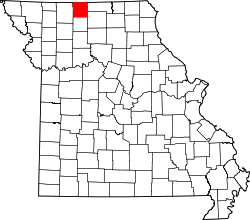
Mercer County, Missouri
 The Mercer County Courthouse in Princeton |
|
| administration | |
|---|---|
| US state : | Missouri |
| Administrative headquarters : | Princeton |
| Address of the administrative headquarters: |
County Courthouse 802 Main Street Princeton, MO 64673-1240 |
| Foundation : | 1845 |
| Area code : | 001 660 |
| Demographics | |
| Residents : | 3785 (2010) |
| Population density : | 3.2 inhabitants / km 2 |
| geography | |
| Total area : | 1179 km² |
| Water surface : | 3 km² |
| map | |
The Mercer County is a county in the US -amerikanischen State Missouri . In 2010 , the county had 3,785 residents and a population density of 3.2 people per square kilometer. The county seat is Princeton . The county ranks 10th in the nation's pig production.
geography
The county is located in northern Missouri and borders Iowa to the north . It has an area of 1179 square kilometers, of which 3 square kilometers are water. The following neighboring counties border Mercer County:
|
Decatur County, Iowa |
Wayne County, Iowa |
|
| Harrison County |

|
Putnam County |
| Grundy County | Sullivan County |
history
Mercer County was formed in 1845. It was named after John F. Mercer (1759-1821), an officer in the American Revolutionary War and later governor of Maryland .
Demographic data
| Population development | |||
|---|---|---|---|
| Census | Residents | ± in% | |
| 1860 | 9300 | - | |
| 1870 | 11,557 | 24.3% | |
| 1880 | 14,673 | 27% | |
| 1890 | 14,581 | -0.6% | |
| 1900 | 14,706 | 0.9% | |
| 1910 | 12,335 | -16.1% | |
| 1920 | 11,281 | -8.5% | |
| 1930 | 9350 | -17.1% | |
| 1940 | 8766 | -6.2% | |
| 1950 | 7235 | -17.5% | |
| 1960 | 5750 | -20.5% | |
| 1970 | 4910 | -14.6% | |
| 1980 | 4685 | -4.6% | |
| 1990 | 3723 | -20.5% | |
| 2000 | 3757 | 0.9% | |
| 2010 | 3785 | 0.7% | |
| Before 1900 1900–1990 2000 2010 | |||
According to the 2010 census , Mercer County had 3,785 people in 1,554 households. The population density was 3.2 people per square kilometer. In the 1554 households there were statistically 2.38 people each.
The racial the population was composed of 97.7 percent white, 0.2 percent African American, 0.5 percent Native American, 0.5 percent Asian and other ethnic groups; 1.1 percent were descended from two or more races. Hispanic or Latino of any race was 0.8 percent of the population.
24.9 percent of the population were under 18 years old, 55.1 percent were between 18 and 64 and 20.0 percent were 65 years or older. 50.1 percent of the population was female.
The median income for a household was 34,008 USD . The per capita income was $ 19,031. 15.9 percent of the population lived below the poverty line.
Towns in Mercer County
structure
Mercer County is divided into nine townships :
| Township | Population (2010) |
FIPS |
|---|---|---|
| Harrison Township | 226 | 29-30538 |
| Lindley Township | 120 | 29-43058 |
| Madison Township | 232 | 29-45452 |
| Marion Township | 826 | 29-46082 |
| Medicine Township | 166 | 29-47108 |
| Morgan Township | 1497 | 29-49952 |
| Ravanna Township | 217 | 29-60662 |
| Somerset Township | 90 | 29-68564 |
| Washington Township | 411 | 29-77578 |
See also
Individual evidence
- ↑ GNIS-ID: 758519. Retrieved on February 22, 2011 (English).
- ↑ a b c U.S. Census Bureau, State & County QuickFacts - Mercer County, MO ( Memento of the original from July 14, 2011 on WebCite ) Info: The archive link was automatically inserted and not yet checked. Please check the original and archive link according to the instructions and then remove this notice. Retrieved November 7, 2012
- ↑ a b National Association of Counties.Retrieved November 7, 2012
- ^ US Census Bureau - Census of Population and Housing.Retrieved March 15, 2011
- ^ Extract from Census.gov.Retrieved February 18, 2011
- ↑ Missouri Census Data Center ( page no longer available , search in web archives ) Info: The link was automatically marked as defective. Please check the link according to the instructions and then remove this notice. Retrieved November 7, 2012
Web links
Coordinates: 40 ° 25 ′ N , 93 ° 34 ′ W
