Henry County, Missouri
![The Henry County Courthouse in Clinton, listed on the NRHP as part of No. 07000019 [1]](https://upload.wikimedia.org/wikipedia/commons/thumb/8/83/Henry_County_Missouri_Courthouse_20191026-2974.jpg/298px-Henry_County_Missouri_Courthouse_20191026-2974.jpg) The Henry County Courthouse, Clinton, listed on the NRHP as part of No. 07000019 |
|
| administration | |
|---|---|
| US state : | Missouri |
| Administrative headquarters : | Clinton |
| Address of the administrative headquarters: |
County Courthouse 100 W. Franklin Street Clinton, MO 64735-2088 |
| Foundation : | 1834 |
| Area code : | 001 660 |
| Demographics | |
| Residents : | 22,272 (2010) |
| Population density : | 12.2 inhabitants / km 2 |
| geography | |
| Total area : | 1897 km² |
| Water surface : | 78 km² |
| map | |
| Website : henrycomo.com | |
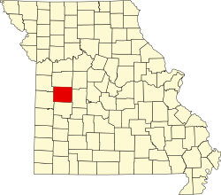
The Henry County is a county in the US state of Missouri . In 2010 , the county had 22,272 residents and a population density of 12.2 people per square kilometer. The county seat is Clinton , which was named after New York Governor DeWitt Clinton .
geography
The county is located west of Missouri in the Northwest Ozarks and is approximately 50 km from Kansas . It has an area of 1897 square kilometers, of which 78 square kilometers are water. The county is traversed by the Osage River , which was dammed here to form the Harry S. Truman Reservoir . The following neighboring counties border Henry County:
| Cass County | Johnson County | Pettis County |
| Bates County |

|
Benton County |
| St. Clair County |
history
| Population development | |||
|---|---|---|---|
| Census | Residents | ± in% | |
| 1840 | 4726 | - | |
| 1850 | 4052 | -14.3% | |
| 1860 | 9806 | 142% | |
| 1870 | 17.401 | 77.5% | |
| 1880 | 23,906 | 37.4% | |
| 1890 | 28,235 | 18.1% | |
| 1900 | 28,054 | -0.6% | |
| 1910 | 27,242 | -2.9% | |
| 1920 | 25,116 | -7.8% | |
| 1930 | 22,931 | -8.7% | |
| 1940 | 22,313 | -2.7% | |
| 1950 | 20,043 | -10.2% | |
| 1960 | 19,226 | -4.1% | |
| 1970 | 18,451 | -4% | |
| 1980 | 19,672 | 6.6% | |
| 1990 | 20,044 | 1.9% | |
| 2000 | 21,997 | 9.7% | |
| 2010 | 22,272 | 1.3% | |
| Before 1900 1900–1990 2000 2010 | |||
Henry County was formed as Rives County on 1834, named after William Cabell Rives , a US Senator from Virginia . After his move to the Whig Party , he lost his popularity and the county was renamed Henry County, it was named after Patrick Henry , an American patriot from Virginia.
Demographic data
According to the 2010 census , Henry County had 22,272 people in 9,459 households. The population density was 12.2 people per square kilometer. Statistically, 2.34 people lived in each of the 9 459 households.
The racial the population was composed of 96.3 percent white, 1.3 percent African American, 0.5 percent Native American, 0.3 percent Asian and other ethnic groups; 1.5 percent were descended from two or more races. Hispanic or Latino of any race was 1.9 percent of the population.
22.1 percent of the population were under 18 years old, 58.2 percent were between 18 and 64 and 19.7 percent were 65 years or older. 51.1 percent of the population was female.
The median income for a household was 35,706 USD . The per capita income was $ 20,304. 16.4 percent of the population lived below the poverty line.
Henry County localities
1 - partially in Pettis County
structure
Henry County is divided into 19 townships :
|
|
See also
Individual evidence
- ↑ Extract from the National Register of Historic Places - No. 07000019 . Retrieved May 3, 2020
- ↑ GNIS-ID: 758496. Retrieved on February 22, 2011 (English).
- ↑ a b c U.S. Census Bureau, State & County QuickFacts - Henry County, MO ( Memento of the original from July 11, 2011 on WebCite ) Info: The archive link was automatically inserted and not yet checked. Please check the original and archive link according to the instructions and then remove this notice. Retrieved October 26, 2012
- ^ A b National Association of Counties.Retrieved October 26, 2012
- ^ US Census Bureau - Census of Population and Housing.Retrieved March 15, 2011
- ^ Extract from Census.gov.Retrieved February 18, 2011
- ↑ Missouri Census Data Center ( page no longer available , search in web archives ) Info: The link was automatically marked as defective. Please check the link according to the instructions and then remove this notice. Retrieved October 26, 2012
Web links
Coordinates: 38 ° 23 ' N , 93 ° 47' W
