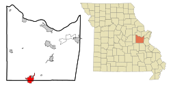
Sullivan, Missouri
| Sullivan | |
|---|---|
|
Location in Missouri
|
|
| Basic data | |
| State : | United States |
| State : | Missouri |
| Counties : |
Crawford County Franklin County |
| Coordinates : | 38 ° 13 ′ N , 91 ° 10 ′ W |
| Time zone : | Central ( UTC − 6 / −5 ) |
| Residents : | 6,351 (as of: 2000) |
| Population density : | 319.1 inhabitants per km 2 |
| Area : | 19.9 km 2 (approx. 8 mi 2 ) of which 19.9 km 2 (approx. 8 mi 2 ) is land |
| Height : | 299 m |
| Postal code : | 63080 |
| Area code : | +1 573 |
| FIPS : | 29-71440 |
| GNIS ID : | 0731658 |
| Website : | www.sullivan.mo.us |
| Mayor : | JT Hardy |
Sullivan is a city that a part in Crawford County and the other in Franklin County in the eastern part of the US -amerikanischen state of Missouri is located. In 2000, Sullivan had 6,351 residents; In 2009, the official estimate was 6763 inhabitants.
geography
Sullivan lies at 38 ° 12'34 "north latitude and 91 ° 09'53" west longitude and extends over 19.94 km², which consists entirely of land. Sullivan is located on the western edge of Meramec State Park , a state park through which the Meramec River flows .
Interstate 44 , which is the shortest connection from St. Louis to Oklahoma City , runs through Sullivan in a southwest-northeast direction . Missouri State Route 185 runs through central Sullivan, and several minor roads meet in the metropolitan area.
A railway line of the BNSF Railway runs through the city from St. Louis to the southwest .
The closest major cities are St. Louis (107 km northeast), Missouri's capital Jefferson City (129 km northwest), Springfield (241 km southwest) and Cape Girardeau (214 km southeast).
history
The first white settlers came to the area around today's city of Sullivan at the beginning of the 19th century. Stephen Sullivan and his wife came to the land on the Meramec River, accompanied by Daniel Boone .
In 1858 the railway came to the region and the settlement grew considerably as a result. The railway company named their station "Sullivan" after the early settler.
Other industries were developing in Sullivan. The International Shoe Company , now known as Meramec Industries , became the city's first nationwide company. Other industrial and trading companies followed. From 1920 to 1960 the population rose from 900 to over 4,000, the second fastest growth in the state of Missouri.
The founding of the Pea Ridge Iron Company in the 1950s brought the population to over 6,000 and made it a center of the region.
Demographic data
In the official census in 2000 , a population of 6351 was determined. These were distributed to 2585 households in 1682 families. The population density was 318.46 inhabitants per square kilometer. There were 3916 residential buildings, which corresponded to a building density of 138.24 buildings per square kilometer.
The population in 2000 was 98.4 percent white , 0.2 percent African American , 0.2 percent Native American , 0.6 percent Asian, and 0.2 percent other. 0.4 percent said they came from at least two of these groups. 1.2 percent of the population were Hispanics belonging to any of the named groups.
25.9 percent were under 18 years of age, 9.3 percent between 18 and 24, 27.5 percent between 25 and 44, 19.5 percent between 45 and 64 and 17.9 percent 65 and older. The mean age was 36 years. For every 100 women there were 89.7 men, among those over 18, 82.3.
The median income per household was 30,046 US dollars (USD), the median family income 36,260 USD. The median income for men was $ 29,817 and that for women was $ 20,385. The per capita income was $ 17,518. Around 6.9 percent of families and 11.0 percent of the total population had their income below the poverty line .
Known residents
- George Hearst (1820–1891) - mining entrepreneur and politician - born in Sullivan
Individual evidence
- ^ US Census Bureau 2009 estimate for Sullivan, Missouri
- ^ Google Maps: Sullivan, MO - St. Louis, MO
- ↑ Google Maps: Sullivan, MO - Jefferson City, MO
- ↑ Google Maps: Sullivan, MO - Springfield, MO
- ↑ Google Maps: Sullivan, MO - Cape Girardeau, MO
- ↑ Sullivan - Gateway to the Ozarks ( Memento of the original from November 29, 2010 in the Internet Archive ) Info: The archive link was automatically inserted and not yet checked. Please check the original and archive link according to the instructions and then remove this notice.
- ↑ U.S. Census Bureau - Sullivan, Missouri
