Springfield, Missouri
| Springfield | |
|---|---|
| Nickname : The Queen City of the Ozarks | |
|
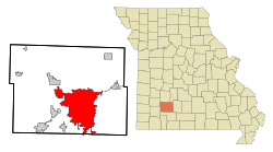
Springfield in Greene County
|
|
| Basic data | |
| Foundation : | 1838 |
| State : | United States |
| State : | Missouri |
| Counties : |
Greene County Christian County |
| Coordinates : | 37 ° 12 ′ N , 93 ° 17 ′ W |
| Time zone : | Central ( UTC − 6 / −5 ) |
|
Inhabitants : - Metropolitan Area : |
167,319 (as of 2016) 458,930 (as of 2016) |
| Population density : | 882.9 inhabitants per km 2 |
| Area : | 191.1 km 2 (approx. 74 mi 2 ) of which 189.5 km 2 (approx. 73 mi 2 ) is land |
| Height : | 396 m |
| Postcodes : | 65800-65899 |
| Area code : | +1 417 |
| FIPS : | 29-70000 |
| GNIS ID : | 0735864 |
| Website : | www.springfieldmo.gov |
| Mayor : | Ken McClure |
Springfield is the third largest city in the US state of Missouri and the county seat of Greene County . The urban area extends with a part in the neighboring Christian County .
Springfield, also known as "The Queen City of the Ozarks ", was founded in 1829 and covers an area of 191 km² . It has 159,498 inhabitants (as of 2010 ). The population density is about 841 inhabitants per km².
Springfield is the seat of the Catholic Diocese of Springfield-Cape Girardeau and the RISS Center Mid-States Organized Crime Information Center (MOCIC). Springfield is home to the United States Medical Center for Federal Prisoners , a hospital for federal prison inmates .
Population development
| year | Residents¹ |
|---|---|
| 1980 | 133,116 |
| 1990 | 140.494 |
| 2000 | 152.466 |
| 2010 | 159,441 |
| 2016 | 167.319 |
¹ 1980–2010: census results; 2016: US Census Bureau estimate
politics
Town twinning
-
 Isesaki , Gunma , Japan
 -
 Tlaquepaque , Jalisco , Mexico
Colleges
- Assemblies of God Theological Seminary
- Baptist Bible College
- Central Bible College
- Global University
- Drury University
- Evangel University
- Forest Institute of Professional Psychology
- Missouri State University
- Ozarks Technical Community College
- St. John's College of Nursing and Health Sciences at Southwest Baptist University
- Vatterott College
- Everest College
- Cox College
- Bryan College
sons and daughters of the town
- Roscoe C. Patterson (1876-1954), politician
- George Hively (1889–1950), screenwriter and film editor
- Horace Eubanks (1894-1948), jazz musician
- Jimmie Angel (1899-1956), pilot
- Bert Grimm (1900–1985), tattoo artist
- Boots Faye (1923-1999), country singer
- Speedy West (1924-2003), country musician
- Jim Lowe (1923-2016), singer
- Alice Kelley (1932–2012), actress and model
- Kathleen Turner (born 1954), actress
- Payne Stewart (1957-1999), professional golfer
- Janet Lynn Kavandi (* 1959), astronaut
- Brad Pitt (born 1963), actor
- Matt Blunt (born 1970), politician and governor of Missouri from 2005–2009
- David Bach (* 1971), poker player
- Lucas Grabeel (* 1984), actor
- Anthony Tolliver (born 1985), basketball player
- Nick Benson (* 1994), actor
- Someone Still Loves You Boris Yeltsin (founded 2004), band
traffic
Springfield is located on Interstate 44 between St. Louis and Tulsa , Oklahoma .
The BNSF Railway operates a major rail hub in Springfield. More than 65 freight trains arrive or leave the city every day. Passenger trains have stopped running in Springfield since 1967.
The regional Springfield-Branson National Airport has around 700,000 passengers annually.
Climate table
| Springfield, Missouri | ||||||||||||||||||||||||||||||||||||||||||||||||
|---|---|---|---|---|---|---|---|---|---|---|---|---|---|---|---|---|---|---|---|---|---|---|---|---|---|---|---|---|---|---|---|---|---|---|---|---|---|---|---|---|---|---|---|---|---|---|---|---|
| Climate diagram | ||||||||||||||||||||||||||||||||||||||||||||||||
| ||||||||||||||||||||||||||||||||||||||||||||||||
|
Average monthly temperatures and rainfall for Springfield, Missouri
|
|||||||||||||||||||||||||||||||||||||||||||||||||||||||||||||||||||||||||||||||||||||||||||||||||||||||||
Web links
- City website
- Springfield Area Chamber of Commerce
- Springfield Public Schools
- 417 Magazine - The lifestyle magazine of Springfield and southwest Missouri
- Springfield News Leader - Local news and information source
Individual evidence
- ^ A b Interactive City Directory . In: Sister Cities International . Retrieved November 21, 2018.
