
Clark Bridge
Coordinates: 38 ° 52 ′ 56 " N , 90 ° 10 ′ 44" W.
| Clark Bridge | ||
|---|---|---|
 in the foreground the Alton Marina |
||
| Official name | Clark Bridge | |
| use | Road bridge | |
| Convicted | US Highway 67 | |
| Crossing of | Mississippi River | |
| place | Alton (Illinois) | |
| construction | Cable-stayed bridge | |
| overall length | 1,408 m | |
| Longest span | 230 m | |
| building-costs | $ 118 million (including old bridge demolition costs) | |
| start of building | June 1990 | |
| opening | January 1994 | |
| location | ||
|
||

The Clark Bridge is a cable-stayed bridge over the Mississippi River from Alton , Illinois to West Alton , Missouri . The bridge, which, like the previous structure, was named after the discoverer William Clark , was opened in 1994. US Highway 67 runs over the bridge and enters the metropolitan area around St. Louis here in a southerly direction .
The 32 m wide new bridge replaced the only 6.1 m wide Old Clark Bridge , which was completed in 1928 and ran parallel to the Alton Bridge . The new bridge has four lanes and also has a cycle lane in each direction.

View from the northwest of the Clark Bridge

The Clark Bridge of Missouri from
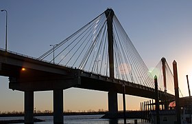
The Clark Bridge from the marina in Alton
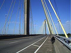
Clark Bridge has two lanes and one cycle lane in each direction


Individual evidence
- ↑ David Goodyear and Ralph Salamie, "The Clark Bridge" ( Memento from June 25, 2008 in the Internet Archive ) (PDF; 909 kB)
Web links
|
Upstream Louisiana Rail Bridge |
Crossing the Mississippi River |
Downriver New Chain of Rocks Bridge |