Hope (Arkansas)
| Hope | |
|---|---|
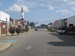
 Downtown Hope |
|
| Location in county and Arkansas | |
| Basic data | |
| Foundation : | 1875 |
| State : | United States |
| State : | Arkansas |
| County : | Hempstead County |
| Coordinates : | 33 ° 40 ′ N , 93 ° 36 ′ W |
| Time zone : | Central ( UTC − 6 / −5 ) |
| Residents : | 10,095 (as of 2010) |
| Population density : | 386.8 inhabitants per km 2 |
| Area : | 26.1 km 2 (approx. 10 mi 2 ) |
| Height : | 107 m |
| Postcodes : | 71801-71802 |
| Area code : | +1 870 |
| FIPS : | 05-33190 |
| GNIS ID : | 0057940 |
| Website : | www.hopearkansas.net |
| Mayor : | Steve Montgomery |
Hope is a city in Hempstead County in the US -amerikanischen State Arkansas with about 10,100 inhabitants (Census 2010) and is the seat of the county administration. The urban area has a size of 25.9 km². The town, founded in 1875, owes its existence to the construction of a regional railway line and was named after the daughter of a railway official. The city is known on the one hand as the home of former President Bill Clinton, on the other hand as a growing area for watermelons, which also serve as a symbol for the city.
Hope is part of the Ark-La-Tex socio-economic region that includes parts of the states of Arkansas, Louisiana , Oklahoma, and Texas . The city is located on Interstate 30 from Fort Worth to Little Rock .
Attractions
|
||||||||||||||||||||||||||||||||||||||||||||||||||||||||||||||||
- Clinton Center and Hope Visitor Center and Museum
- Southwest Proving Ground Museum
- President William Jefferson Clinton Birthplace Home
sons and daughters of the town
- Joseph Barton Elam (1821–1885), politician, member of the US House of Representatives
- Bill Clinton (born 1946), 42nd President of the United States
- Gregory Davis (born 1982), basketball player
- Melinda Dillon (born 1939), actress
- Mike Huckabee (born 1955), governor of Arkansas
- Buddy Jones (1924-2000), jazz musician
- Mack McLarty (born 1946), politician and businessman, Chief of Staff of the White House
- Sarah Huckabee Sanders (* 1982), White House Press Secretary
Individual evidence
- ^ Arkansas Municipal League - Hope , accessed March 2, 2018
- ^ Extract from the Encyclopedia of Arkansas . Retrieved February 13, 2011
Web links
Commons : Hope, Arkansas - collection of pictures, videos, and audio files
- Official website (English)
- City profile on arkansas.com (English)
- Chamber of Commerce of Hope (English)

