US Highway 26
| map | |
|---|---|

|
|
| Basic data | |
| Overall length: | 1485 mi / 2390 km |
| Opening: | 1926 |
| States: |
Nebraska Wyoming Idaho Oregon |
| Starting point: |
|
| End point: |
|
| Important cities: |
Casper, WY Idaho Falls, ID Boise, ID Portland, OR |
The US Highway 26 (also US Route 26 or US 26 ) is a 2390 km long extending in an east-west direction Highway in the northwest of the United States . It was opened in 1926 and is part of the United States Numbered Highway System . The highway begins on Interstate 80 near the small town of Ogallala , Nebraska , runs through the states of Wyoming and Idaho and ends on the west coast of the United States on US Highway 101 south of the coastal city of Seaside , Oregon . Historic routes that US 26 follows in part include the Oregon Trail , Mormon Trail, and California Trail .
history
US Highway 26 opened in 1926. Its eastern end was from the beginning at Ogallala, Nebraska . With only a few US highways running in an east-west direction, the east end is that far west. At that time, US 26 branched off from US Highway 30 west of Ogallala ( location ). After the construction of Interstate 80 , US 26 was extended to its junction south of Ogallala ( Lage ).
The western end of US 26 was until 1948 on the (now abandoned) US Highway 185 (now WY 320) at Dwyer Junction ( location ), about 15 km west of Guernsey, Wyoming . From 1948 to 1952 it was gradually expanded to the west. In 1948 the US 26 then led to Alpine, Wyoming ( location ) on the western border of Wyoming , in 1951 to Idaho Falls ( location ) and in 1952 to Astoria, Oregon ( location ). On its last section, it was the same route as US Highway 101 . At that time the US 26 had its maximum length of 1557 mi (2506 km). In 2003, its western end was moved back to its junction with US 101 ( location ) between Seaside and Cannon Beach .
course
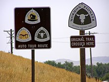
Over much of its course, the highway follows the the National Trails System belonging Oregon Trail , a historic trading and settlement route of the 19th century over the Rocky Mountains . In the eastern section of the highway it also follows the Mormon Trail , the route of the Mormon pioneers in the mid-19th century, and the California Trail , one of the main routes for settlers and prospectors to California , both of which are also part of the National Trails System. Signs placed by the National Park Service next to the road indicate the historic trails and related sites.
Nebraska
In Nebraska , the US 26 runs from its junction from Interstate 80 ( location ), which is south of Ogallala on the South Platte River , after a short joint route with the US 30 mainly to the northwest until it reaches Lewellen ( location ) above the Lake McConaughy reaches the North Platte River . He passes the Ash Hollow State Historical Park ( location ) with Windlass Hill , where the early settlers had to drive down a steep slope, and the Ash Hollow Cave , a half-cave classified as a National Historic Landmark (NHL) with archaeological finds from three millennia .
In the further course of the US 26 follows approximately the North Platte River upstream to the northwest. In this section, the Oregon Trail ran on the south bank of the river, the Mormon Trail on the north bank. The US 26 changes sides of the river several times. Distinctive landmarks in this area are the crag of Chimney Rock ( Lage ) and the cliff of Scotts Bluff ( Lage ) near the town named Scottsbluff ( Lage ).
Wyoming
In Wyoming , the US 26 follows the North Platte River upstream to the northwest and passes the towns of Torrington ( Lage ) and Fort Laramie ( Lage ). The historic Fort Laramie ( location ), after which the city was named, was located at the confluence of the Laramie River with the North Platte River and secured the route of the settlers. At the south of Guernsey situated Register Cliff ( location ) many settlers carved their names into a sandstone ridge. At the nearby Oregon Trail Ruts ( location ), the wagons and their draft animals left clear tracks in a sandstone rib . In Guernsey, the US 26 crosses the North Platte River ( Lage ) south of the Guernsey Reservoir in Guernsey State Park and runs west towards Laramie Peak ( Lage ). About 2 km past its original terminus at Dwyer Junction ( Lage ), it meets Interstate 25 ( Lage ) and follows it north back to the river. In the further course along the river the US 26 follows its curve to the west and passes the Ayres Natural Bridge Park ( Lage ), in which a natural rock bridge leads over the LaPrele Creek.
Behind Casper ( Lage ) the US 26 leaves the Interstate, the river valley and the historic trails and leads through mountainous terrain until it meets the south end of Boysen Reservoir ( Lage ) in Boysen State Park behind Shoshoni ( Lage ) . It follows the course of the Wind River that feeds this reservoir south to Riverton ( location ) and then further northwest to its headwaters ( location ) in the Wind River Range of the Rocky Mountains . There it crosses the continental watershed south of Breccia Peak at the Togwotee Pass ( Lage ) at an altitude of 2944 m . From there it runs west until it reaches the Snake River at Moran ( location ) east of the Teton Range . From the road, the glacier on the north flank of the Grand Teton ( location ) can be seen clearly. The US 26 follows the river along the Jackson Hole through Grand Teton National Park ( Lage ) to Jackson ( Lage ) and further along the edge of the Bridger-Teton National Forest ( Lage ) to its former western end near Alpine, Wyoming ( Lage ) at the Palisades Reservoir on Wyoming's western border.
Idaho
In Idaho , the US 26 follows the Snake River into the Snake River Plain via Idaho Falls ( location ), where it ended 1951-1952, to Blackfoot ( location ), near Fort Hall ( location ), another Oregon station Trails lies. The US 26 does not follow its original route, however, but leaves the river and runs along the Goodale cutoff at the north end of the Craters of the Moon National Monument ( Lage ), an area with large-scale cooled lava flows. Then it leaves the Goodale cutoff to the south, leads through Shoshone ( location ) and Gooding ( location ) and meets the river again at Bliss ( location ) and thus on the original Oregon Trail.
After about 50 km it leaves the river again at Hammett ( Lage ) and follows a branch of the Oregon Trail, which runs parallel to the Snake River at a distance of about 20 km, to Boise ( Lage ). From there it follows the Boise River , at whose confluence with the Snake River was the old Fort Boise ( location ), near which the settlers crossed the Snake River at a ford, later also by ferry. The US 26 crosses the Snake River, which forms the border between Idaho and Oregon in this section, a few kilometers further north over the Nyssa Bridge ( Lage ).
Oregon

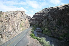
In Oregon , the US 26 from Nyssa ( Lage ) initially follows the Snake River and then swings westwards just before Ontario ( Lage ) to Vale on the Malheur River ( Lage ). This was the first stop on the Oregon Trail after arriving in Oregon. While the historic trail led north from here back to the Snake River and only finally left it at Huntington to get through the Blue Mountains to the Columbia River , the US 26 runs from Vale to the northwest. It crosses the southern end of the Blue Mountains in the area of the Malheur National Forest ( location ) on a mountain pass that rises to a height of 1545 m . It then descends into the valley of the John Day River , which it reaches at Prairie City ( location ). It follows the river into the Picture Gorge ( location ), a rock canyon with Indian rock art in the John Day Fossil Beds National Monument . There it leaves the river via a side valley and leads through the mountainous Ochoco National Forest ( Lage ) west to Prineville ( Lage ) and from there in a north-west direction to Madras ( Lage ).
From Madras, the US 26 continues to the northwest via Warm Springs ( Lage ) and on through the Warm Springs Reservation ( Lage ) and the Mount Hood National Forest ( Lage ) towards Mount Hood . On its southern flank it reaches the historic Barlow Road ( Lage ), which since 1846 has offered the settlers an overland route across the Cascade Range to the west. Covered wagons could also drive this road, while the Columbia River Gorge could only be walked or horse-drawn and before the road was built, a raft ride on the Columbia River was the only way covered wagons could get into the Willamette Valley . US 26 follows Barlow Road to Sandy ( Lage ) and then leads into Portland ( Lage ), where it crosses the Willamette River over the Ross Island Bridge ( Lage ). West of Portland, US 26 is known as the "Sunset Highway". It crosses the Oregon Coast Range ( location ) and ends on the west coast on US Highway 101 ( location ) between Cannon Beach and Seaside .
Other trunk roads
US Highway 26 runs in sections on the same route as Interstates or other US highways. The common route sections with interstates include (from east to west):
- Interstate 25 : from approximately 2 km west of Dwyer Junction ( location ) to Casper ( location ), 97 mi / 156 km
- Interstate 15 : Idaho Falls ( Location ) to Blackfoot ( Location ) 23 mi / 37 km
- Interstate 84 : from Bliss ( able ) to Boise ( able km), 86 mi / 138
- Interstate 84 : at Caldwell ( location ), 2.8 mi / 4.5 km
The US highways that have sections in common with the US 26 include (from east to west): US 30 , US 85 , US 20 , US 87 (together with I-25), US 287 , US 89 , US 191 , US 189 , again US 20, US 93 , again US 20 and US 30 (together with I-84), US 95 , US 395 , US 97 .
In Portland, US 26 crosses Interstates 5 , 205 and 405 . The US highways that cross or end at US 26 include (from east to west): US 385 , US 18 , US 91 .
In Prineville ( location ) a road branches off leading to Eugene , which was run from 1951 to 1972 as US Highway 126, but was then downgraded to State Highway OR 126.
Web links
- Endpoints of US Highway 26 at www.usends.com
- US Highway 26 at AARoads
Individual evidence
- ↑ a b End of US highway 26. In: www.usends.com. Retrieved December 17, 2017 .


