Columbia River Gorge
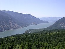
The Columbia River Gorge is the vast rocky gorge of the Columbia in the Pacific Northwest of the United States of America . In it the river breaks the cascade chain . The valley stretches from The Dalles to Crown Point and largely forms the border between the states of Washington (southern border) and Oregon (northern border). The largest locations on the gorge are Hood River and The Dalles. Two large dams, The Dalles Dam and the Bonneville Dam, defuse the rapids and generate energy.
The gorge is also home to the largest collection of waterfalls in the Pacific Northwest, including Multnomah Falls with an impressive height difference of 188 m.
Geology and vegetation
Over the ages, the Columbia River has drifted deep into the volcanic rock of the Columbia Plateau Basalt. The last major erosion occurred during the Missoula Floods in the last Ice Age about 13,000 years ago. In the early 17th century, the "Bonneville Slide" occurred, a large landslide as a result of which the Columbia was dammed. When the river finally eroded the loose soil, a natural bridge was created over the Columbia River, but it collapsed again in a later volcanic eruption. The indigenous Native Americans remember the event in their legends and call it the Bridge of the Gods . A bridge that was inaugurated in 1926 is now called the Bridge of the Gods .
Frequent rain nourishes the forest and the many waterfalls over the basalt rocks. The valley is overgrown with conifers , maple trees, poplars , oaks and ash trees. The different heights and the different rainfall in the regions has produced a biological diversity of ecosystems , for example a temperate rainforest at Oneonta Gorge (average rainfall 190 cm p. A. ) Or the Celilo meadows (average rainfall 30 cm). There is also a rich wildflower population . Wine is grown on the slopes, especially on the Oregon side (e.g. Hood River Vinery).
Settlement history
The valley has been populated for about 13,000 years. The existence of the Folsom and Marmes people , who immigrated from Asia via the Beringia , has been proven in excavations. Excavations at Celilo Falls (not far from The Dalles town) showed that humans have inhabited this ideal salmon fishing spot for over 10,000 years.
For many centuries the valley between the Deschutes River and Portland was the only route through the Cascade Mountains . In 1805 the Lewis and Clark Expedition used the valley to reach the Pacific . From 1913 to 1922, the Historic Columbia River Highway was built on the Oregon side of the Columbia River as a tourist road, and what is now Interstate 84 was built next to it until 1960 to accommodate the increasing traffic . With these roads, the valley is an important transport corridor and one of the most important tourist routes in the Pacific Northwest .
In November 1986 the US Congress decided to declare the valley the first US National Scenic Area because of its unique beauty . There are numerous state parks within the valley, especially on the Oregon side .
Others
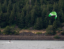
Atmospheric pressure differences east and west of the Cascade Mountains create a wind tunnel effect in the lower areas of the gorge. Therefore, many windsurfers and kite surfers can be found here. The river is known worldwide for its ideally suited water points.
Web links
- Official site of the Columbia River Gorge National Scenic Area (English)
- The Evolving Landscape of the Columbia River Gorge: Lewis and Clark and Cataclysms on the Columbia ( March 8, 2005 memento on the Internet Archive ) Article by Jim E. O'Connor on the geology of the Columbia Gorge, published in the Oregon Historical Quarterly Fall 2004 (in English)
- Entry in the Washington encyclopedia HistoryLink (English)
- Historic Columbia River Highway (English)
Coordinates: 45 ° 42 ′ N , 121 ° 48 ′ W


