The Dalles Dam
| The Dalles Dam Lake Celilo |
|||||||||
|---|---|---|---|---|---|---|---|---|---|
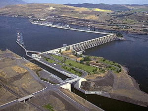
| The Dalles Dam, looking towards Oregon | |||||||||
|
|||||||||
|
|
|||||||||
| Coordinates | 45 ° 36 '44 " N , 121 ° 8' 4" W | ||||||||
| Data on the structure | |||||||||
| Lock type: | Gravity dam | ||||||||
| Construction time: | 1952-1957 | ||||||||
| Crown length: | 441 m (spillway) 638 m (powerhouse) |
||||||||
| Base width: | 73 m | ||||||||
| Power plant output: | 1 780 MW | ||||||||
| Operator: | US Army Corps of Engineers, Bonneville Power Administration | ||||||||
| Data on the reservoir | |||||||||
| Water surface | 38 km² | ||||||||
| Reservoir length | 39 km | ||||||||
| Western part of Lake Celilo from the dam (left) to the former Celilo Falls behind the Celilo Bridge | |||||||||
The The-Dalles Dam ( english The Dalles Dam ) is a barrage on the Columbia River three kilometers east of The Dalles in Oregon , USA. The dam has an L-shaped concrete gravity dam with a run-of-river power plant and has dammed the Columbia to Lake Celilo since 1957 , which extends 39 km upstream to the west to the John Day Dam . The Dalles Dam is operated by the United States Army Corps of Engineers and, like the downstream The Dalles Bridge, connects Wasco County in Oregon with Klickitat County in Washington. It is 309 km upstream from the mouth of the Columbia at Astoria and borders Lake Bonneville 's next barrage , the Bonneville Dam .
Barrage

The Dalles Dam was proposed by the United States Army Corps of Engineers in the 1930s as part of a plan to develop the Columbia as an energy source and develop the river as a shipping lane . It comprised several barrages, the first of which were built from 1933, including the Bonneville Dam (1937) and the Grand Coulee Dam (1941). Construction of the barrage at The Dalles began in 1952 and was completed in 1957.
In 2014 the structure was included in the list of historical milestones in civil engineering by the American Society of Civil Engineers (ASCE) .
The L-shaped The Dalles Dam consists of three parts. On the Washington side is the lock with a width of 26 m and 206 m length, with which ships can cope with a height difference of 27 m in 30 minutes. This is followed by the 441 m long weight dam of the spillway running across the river , with a base width of 73 m. It has 23 gates of 15 m × 23 m designed as pressure segment weirs . The 638 m long run-of-river powerhouse runs parallel to the river on the Oregon side . It has 22 water turbines (14 from 1957 and expanded to 22 by 1973) with a total of 1,780 MW.
Reservoir

The reservoir Lake Celilo and covers an area of 38 extends 39 km upstream to the John Day Dam on the west. It borders south on Wasco Counties and Sherman Counties in Oregon and north on Klickitat County in Washington. It is also fed by the Deschutes River , a tributary that flows from the south on half of the reservoir into the Columbia River . Only two bridges cross the reservoir. To the east the Sam Hill Memorial Bridge , a two-lane road bridge between Maryhill (Washington) and Biggs Junction (Oregon) , and downstream to the west the Oregon Trunk Rail Bridge (Celilo Bridge) , a railway bridge of the BNSF Railway near Wishram (Washington) .
With the damming of the lake from March 10, 1957, many centuries-old fishing grounds and settlement areas were flooded by tribes of the Confederated Tribes and Bands of the Yakama Nation , including the Celilo Falls , a series of rapids and waterfalls near Wishram, as well as parts of the adjacent Celilo Village on the Oregon side.
See also
- List of the largest dams and reservoirs on earth
- List of the largest hydroelectric plants in the world
- List of dams in the United States
- List of bridges, ferries, barrages, and cable cars across the Columbia River
Web links
- The Dalles Dam and Lake Celilo. US Army Corps of Engineers, Columbia Basin Water Management Division.
- The Dalles Dam and Lake Celilo. US Army Corps of Engineers, Columbia River System Operations.
- The Columbia River System Inside Story. US Bureau of Reclamation, US Army Corps of Engineers and Bonneville Power Administration, 2001.
Individual evidence
- ^ William F. Willingham: The Dalles Dam. The Oregon Encyclopedia, Portland State Univ. and Oregon Historical Society. Retrieved August 30, 2017.
- ↑ Building Strong® at The Dalles Lock and Dam. US Army Corps of Engineers, Portland District. Retrieved August 30, 2017.
- ^ The Dalles Lock and Dam - Fact Sheet. US Army Corps of Engineers, Portland District. Retrieved August 30, 2017.
- ↑ Lake Celilo, Washington. In: lakepedia.com. Retrieved August 29, 2017 .
- ^ Katrine Barber: Celilo Falls. The Oregon Encyclopedia, Portland State Univ. and Oregon Historical Society. Retrieved August 30, 2017.


