Bonneville Dam
| Bonneville Dam Lake Bonneville |
|||||||
|---|---|---|---|---|---|---|---|
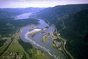
| The Bonneville structure with dam, hydroelectric power stations, the locks and Lake Bonneville (in the background) | |||||||
|
|||||||
|
|
|||||||
| Coordinates | 45 ° 38 '39 " N , 121 ° 56' 26" W | ||||||
| Data on the structure | |||||||
| Lock type: | Gravity dam | ||||||
| Construction time: | 1933-1937 | ||||||
| Height of the barrier structure : | 60 m | ||||||
| Crown length: | 820 m | ||||||
| Power plant output: | 1 092.9 MW | ||||||
| Data on the reservoir | |||||||
| Storage space | 662 million m³ | ||||||
| Catchment area | 620 000 km² | ||||||

The Bonneville Dam is a dam with large locks that dams the Columbia River . Since the river forms the border between the US states of Oregon and Washington , the structure belongs to both states. It is located approximately 60 km east of Portland and the nearest city is Hood River 30 km to the east. The complex was built by and is maintained by the United States Army Corps of Engineers . Close to the dam is the John B. Yeon State Scenic Corridor .
The name comes from Army Captain Benjamin Bonneville (1796–1878) who, among other things, mapped the Oregon Trail .
The locks and hydroelectric power station were built between 1933 and 1937 as part of the New Deal program . The original lock was opened in 1938 and was the largest single-gate lock in the world at the time.
During the Great Depression , construction gave many people jobs. Furthermore, the structure still supplies the aluminum smelters in the area with electricity and ensures navigability for approx. 200 km upstream. The construction of a second hydropower plant and another dam began in 1974 and completed in 1981.
The structure includes the following technical systems and geographical objects:
- First hydropower plant - construction period 1933–1937; Length 313 m; By hydropower is on the dam by generators electrical energy gained. The electricity is sold through the Bonneville Power Administration, a commercial enterprise of the Federal Department of Energy ; ten generators with an output power of 526,700 kW .
- Flood relief basin - construction period 1933–1937; 18 gates over a length of 442 m; it is usually 18 m above the water surface upstream.
- Second hydropower plant - construction period 1974–1981; Length 300.5 m; eight generators with an output of 558,200 kW. There are also two fish ladders here .
- Bonneville Lock, completed in 1993; Construction Cost: $ 341 million; Length: 206 m; Width: 26 m. A lock takes about 30 minutes.
- Lake Bonneville at Cascade Locks - length: 77 km; The lake, which serves as a reservoir , is dammed by the Bonneville Dam and is part of the Columbia-Snake Inland Waterway .
Bonneville Dam has been listed as a Historic District on the National Register of Historic Places since April 1986 . In March the following year, the protected area was expanded. Since June 1987 the dam has the status of a National Historic Landmark . The Bonneville Dam was added to the List of Historic Civil Engineering Landmarks by the American Society of Civil Engineers in 1987.
Visitor centers (Bonneville Lock and Dam visitor centers) are located in both Oregon and Washington. The supervision of all facilities is carried out by the US Army Corps of Engineer park rangers ; they also do the tours.
See also
- List of the largest dams on earth
- List of the largest reservoirs on earth
- List of the largest hydroelectric plants in the world
- List of dams in the United States
- List of the historical milestones in engineering
Web links
- US Army Corps of Engineers - Bonneville Lock and Dam (English)
- Information from the American Society of Civil Engineers (English)
- Bonneville Power Administration (English)
Individual evidence
- ^ Bonneville Dam Historic District on the National Register Information System. National Park Service , accessed February 8, 2020.
- ^ Bonneville Dam Historic District (Boundary Increase) on the National Register Information System. National Park Service , accessed February 8, 2020.
- ↑ Listing of National Historic Landmarks by State: Oregon. National Park Service , accessed February 8, 2020.


