Cascade locks
| Cascade locks | |
|---|---|
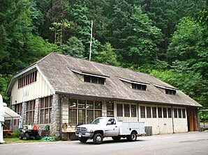
 Cascade Locks Work Center |
|
| Location in Oregon | |
| Basic data | |
| Foundation : | 1935 |
| State : | United States |
| State : | Oregon |
| County : | Hood River County |
| Coordinates : | 45 ° 40 ′ N , 121 ° 52 ′ W |
| Time zone : | Pacific ( UTC − 8 / −7 ) |
| Residents : | 1,055 (as of: 2000) |
| Population density : | 188.4 inhabitants per km 2 |
| Area : | 7.7 km 2 (approx. 3 mi 2 ) of which 5.6 km 2 (approx. 2 mi 2 ) is land |
| Height : | 51.8 m |
| Postal code : | 97014 |
| Area code : | +1 (541) 374 |
| FIPS : | 41-11600 |
| GNIS ID : | 1139422 |
| Website : | www.cascade-locks.or.us |
| Mayor : | Lance Masters |
Cascade Locks is a small town in Hood River County , northern Oregon . Originally, a couple of tree trunks were set up here to improve navigation on the Columbia to the Cascades Rapids . The lock was completed on November 5, 1896. The weirs were gradually merged in 1938, but were eventually replaced by the Bonneville Dam . The place named after the weirs today has 1,055 inhabitants and 427 households on an area of 7.7 km².
Cascade Locks is upriver from the Bridge of the Gods , a major toll bridge over the Columbia, the only one between Portland and Hood Rivers . Interstate 84 runs through the town .
Cascade Locks is on the Pacific Crest Trail (PCT), where the Columbia is crossed; the location is the lowest on this path between Mexico and Canada.
The National Park Service has three structures and sites for Cascade Locks on the National Register of Historic Places (NRHP) (as of December 25, 2018), including the Cascade Locks Work Center .
Web links
Individual evidence
- ↑ Search mask database in the National Register Information System. National Park Service , accessed December 25, 2018.
