Hood River (Oregon)
| Hood River | |
|---|---|
 Lester and Hazel Murphy House |
|
| Location in Oregon | |
| Basic data | |
| Foundation : | 1895 |
| State : | United States |
| State : | Oregon |
| County : | Hood River County |
| Coordinates : | 45 ° 40 ′ N , 121 ° 31 ′ W |
| Time zone : | Pacific ( UTC − 8 / −7 ) |
| Residents : | 6,580 (as of 2006) |
| Population density : | 1,241.5 inhabitants per km 2 |
| Area : | 7.5 km 2 (approx. 3 mi 2 ) of which 5.3 km 2 (approx. 2 mi 2 ) is land |
| Height : | 48.8 m |
| Postal code : | 97031 |
| Area code : | +1 (541) 387 |
| FIPS : | 41-34900 |
| GNIS ID : | 1136388 |
| Website : | www.ci.hood-river.or.us |
| Mayor : | Linda prank |
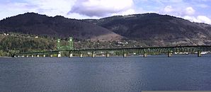
 Hood River Bridge (length 1,449.32 m) |
|
Hood River is an American small town in northern Oregon and administrative seat of Hood River County .
location
The place with an extreme slope is located in the cascade chain on the Columbia River Gorge , directly south of the Columbia River . The city of Portland is 90 km to the west . While the old town lies directly on the bank ( 40 m high) or on a slope, the newer settlement is on a plateau with about 140-170 m.

history
Hood River was officially established in 1856. The name comes from the river of the same name , which flows into the Columbia River here .
The National Park Service has 27 structures and sites on the National Register of Historic Places (NRHP) for Hood River as of December 25, 2018, including the Lester and Hazel Murphy House .
today
The weather is often changeable and especially windy (19.6 km / h in January). The city lives from national tourism ( surfing , mountain sports ) and fruit growing (pears, apples). The fruit is exported to many countries.
It is twinned with the Japanese town of Tsuruta in Aomori Prefecture .
traffic
Interstate 84 runs along the Columbia River . A toll bridge runs from Hood River over the Columbia River to White Salmon in Washington State . There is a marina a few meters to the east . Ken Jernstedt Airfield is located in the south of the city .
sons and daughters of the town
- Cecil D. Andrus (1931–2017), politician
Web links
- www.ci.hood-river.or.us Website of the city (English)
- Hood River, OR Chamber of Commerce (English)
Individual evidence
- ↑ Search mask database in the National Register Information System. National Park Service , accessed December 25, 2018.
- ↑ www.sister-cities.org ( Memento of the original from June 22, 2015 in the Internet Archive ) Info: The archive link was automatically inserted and not yet checked. Please check the original and archive link according to the instructions and then remove this notice. , accessed June 9, 2013
