Arrow Lakes
| Arrow Lakes Upper Arrow Lake / Lower Arrow Lake Hugh Keenleyside Dam |
|||||||||
|---|---|---|---|---|---|---|---|---|---|
|
|||||||||
|
|
|||||||||
| Coordinates | 49 ° 57 ′ 20 ″ N , 118 ° 0 ′ 0 ″ W | ||||||||
| Data on the structure | |||||||||
| Construction time: | ? –1968 | ||||||||
| Height of the structure crown: | 52 m | ||||||||
| Crown length: | 853.4 m | ||||||||
| Power plant output: | 185 MW | ||||||||
| Operator: | BC Hydro | ||||||||
| Data on the reservoir | |||||||||
| Altitude (at congestion destination ) | 440 m | ||||||||
| Water surface | 390.4 km² | ||||||||
| Reservoir length | 232 km | ||||||||
| Storage space | 8.76 km³ | ||||||||
| Dam and power station | |||||||||
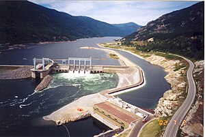
The Arrow Lakes form a reservoir created by the construction of the Hugh Keenleyside Dam in southern British Columbia , through which the Columbia River flows.
location
The 232 km long lake stretches from the Hugh Keenleyside Dam - built about 10 km northwest of Castlegar - to almost the Revelstoke Dam , which damms the Columbia River a few kilometers north of Revelstoke into a reservoir . At high tide, the storage volume is 8.76 km³, the height of the lake level fluctuates between 419 and 440 meters above sea level , whereby at low tide the division of the lake that existed before the construction of the dam is still visible.
The Upper Arrow Lake and Lower Arrow Lake are through a constriction, the Narrows , separated from each other is called. The Upper Arrow Lake has a surface of about 226.5 km², the Lower Arrow Lake has a surface of about 163.9 km² at low tide.
The location in a valley between the Monashee Mountains and the Selkirk Mountains characterizes the landscape of the lake, which is only a few hundred meters wide, so that there are only a few flat areas on its banks. Instead, the heavily forested steep slopes of the up to 2,600 m high mountain ranges fall over steep cliffs into the lake.
Three ferries connect different roads, most of which run close to the banks:
- Shelter Bay - Galena (Highway 23 with Highway 23 or Highway 31)
- Arrow Park - East Arrow Park (Lower Mosquito Rd. And Saddle Mountain-Revelstoke Rd. With Highway 6)
- Needles - Fauquier (Highway 6 with Highway 6)
There is no continuous road connection on both banks.
Arrow Lakes Provincial Park is located on the western shore of the lake .
Keenleyside Dam
The dam - originally named the High Arrow Dam - was built in 1968 as Canada's contribution to fulfilling the Columbia River Treaty of January 1961. Originally only intended to control the discharge of the Columbia River , a hydropower plant with an output of 185 megawatts was only built in 2002 . The dam and power station are operated by BC Hydro .
Web links
- Arrow Lakes . In: BC Geographical Names (English)


