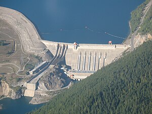
Revelstoke Dam
| Revelstoke Dam Lake Revelstoke |
|||||||||
|---|---|---|---|---|---|---|---|---|---|
| Aerial view of the dam | |||||||||
|
|||||||||
|
|
|||||||||
| Coordinates | 51 ° 2 '58 " N , 118 ° 11' 38" W | ||||||||
| Data on the structure | |||||||||
| Construction time: | until 1984 | ||||||||
| Height above foundation level : | 175 m | ||||||||
| Power plant output: | 2 480 MW | ||||||||
| Operator: | BC Hydro | ||||||||
| Data on the reservoir | |||||||||
| Water surface | 115.34 km² | ||||||||
| Storage space | 5300 million m³ | ||||||||
The Revelstoke Dam is a large dam with a hydroelectric power station on the Columbia River and is located five kilometers north of Revelstoke in the Canadian province of British Columbia . The power plant was completed in 1984 and has a nominal generator output of 1843 MW . It is one of the largest and most modern hydropower plants in North America. The reservoir behind the barrier is called Lake Revelstoke. The dam is operated by BC Hydro .
The Columbia River Treaty
The construction of the power plant is based on a contract from 1964 between the USA (where the electricity is supplied) and Canada (the "Columbia River Treaty"). The Revelstoke Dam is Canada's second hydropower project on the Columbia River and one of four dams in British Columbia that regulate the flow of the Columbia. The other three are Mica, Hugh Keenleyside, and Duncan . They were all established under the 1964 Treaty; According to another source, Revelstoke is not under the contract. The treaty also regulates flood protection and supports the potential for the use of hydropower in the USA. The dam is also dimensioned for tidal waves that could result from potential landslides and rockfalls.
The barricades
The dam has a 175 m high concrete gravity dam in the Little Dalles Canyon as a barrier structure and an additional 122 m high earth embankment on the west bank of the river.
The power plant
The power house is located directly under the dam . It has four 16 kV generators with a nominal output of 460.75 MW each , which have been in operation since 1984. The system, which is connected to the 500 kV power grid, is designed for the operation of a maximum of six turbines; The current nominal power is therefore 1843 MW; it could be increased to 2764.5 MW. The alternatively specified output of 1980 megawatts probably relates to the output of the turbines . After the new turbine was installed, the output rose to 2480 MW according to official information. The machines are among the largest there are. The power house is 213 m long, 50 m wide and 60 m high. The power plant offers visitors an information center on the history of the dam with a wealth of information on its structure and mode of operation. Furthermore, guided tours are organized, but they do not allow entering the turbine hall.
The reservoir
The reservoir is 135 km to the north from the Mica Dam . It is located below Mica at the “Meile 882” station, is approx. 130 km long and extends as far as the Mica dam. Both dams are operated together in a network. Three quarters of the inflow are regulated outflows of mica, and therefore the Revelstoke power plant operates as a hydroelectric power plant and less than storage power plant . The normal water level changes in the reservoir are only 4.5 meters.
See also
- List of the largest dams on earth
- List of the largest reservoirs on earth
- List of the largest hydroelectric plants in the world
- List of dams in the world # Canada
Web links
- Dams of the Columbia Basin & Their Effects on the Native Fishery
- BC Hydro Revelstoke Dam Visitor Center website
Individual evidence
- ↑ What's Being Done ( Memento from January 17, 2013 in the web archive archive.today )
- ↑ http://www.bchydro.com/etc/medialib/internet/documents/projects/revelstoke/Revelstoke_ProjBackgrounder_2011-Fall.Par.0001.File.Revelstoke-ProjBackgrounder-2011-Fall.pdf ( Memento from September 7, 2012 in Internet Archive )

