US Highway 73
| map | |
|---|---|

|
|
| Basic data | |
| Overall length: | 112 mi / 180 km |
| Opening: | 1926 |
| States: |
Kansas Nebraska |
| Starting point: |
|
| End point: |
|
| Important cities: |
Kansas City Leavenworth Atchison Falls City |
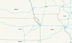
The US Highway 73 (short US 73 ) is a United States highway in the United States . It begins in the state of Kansas on Interstate 70 near Bonner Springs and ends after 180 kilometers on US Highway 75 near Dawson in the state of Nebraska .
course
Kansas
From Interstate 70 near Bonner Springs west of Kansas City , US Highway 73 runs north and meets US Highways 24 and 40 after about two kilometers . From the town of Leavenworth , the road runs northwest parallel to the Missouri River . In the center of Atchison , the US 73 uses the route of the US Highway 59 for about two kilometers and leaves the city in a westerly direction. From Horton it runs together with US Highway 159 north. The route meets south of Hiawatha on the US Highway 36 and reaches north of the reserve , the border with Nebraska.
Nebraska
Already in Falls City , the first city through which US Highway 73 runs in Nebraska, it separates from US Highway 159. US 73 leaves Falls City in a northerly direction and passes the Brenner Field Airport . From the junction of the Dustless Highway , the highway heads west and then crosses the village of Verdon before ending after 180 kilometers on US Highway 75 north of Dawson.
Web links
- Nebraska Highways (English)
- US Highway Ends (English)
