
Route 66
| map | |
|---|---|

|
|
| Basic data | |
| Overall length: | 2,451 mi / 3,945 km |
| Opening: | 1926 |
| States: |
Illinois Missouri Kansas Oklahoma Texas New Mexico Arizona California |
| Starting point: | Chicago (Illinois) |
| End point: | Santa Monica (California) |

The Route 66 was originally 2,451 miles (3,945 km) long road ( US Highway ) in the highway system of the United States of Chicago ( Illinois ) to Santa Monica / LA ( California ). It was considered from 1926, apart from the Lincoln Highway , as one of the first continuously paved road links to the west coast . Today the remaining sections of the route, formerly called Mother Road or Main Street of America , are a magnet for tourists and nostalgics. However, it is no longer uniformly referred to as Route 66 and can no longer be used continuously.
history
The beginning

The first driving routes to the west, some of which the settlers had already traveled with their covered wagons, were easy paths through the prairie and not yet paved roads. The National Old Trails Road (also called Ocean-to-Ocean Highway ), which ran from Baltimore in the east (some maps also indicated New York as the beginning) to the west through the USA , existed since 1912. The route ran through Arizona and California to a large extent there where Route 66 was later to run.
In 1915, a motorcyclist named Erwin G. Baker made headlines in the USA , who crossed the country from coast to coast in eleven days and then reported on “paths like freshly plowed fields”. In the wake of the rise of motor vehicle traffic after the First World War , many roads were built - the call was loud for a continuous paved road connection from the east to the west coast, which was still largely separated from the rest of the country by the Rocky Mountains and deserts .
The important and symbolic east-west connection was gradually expanded as "US Highway 66" from 1926, also by simply connecting existing roads with one another.
The planner is Cyrus Stevens Avory (from Tulsa / Oklahoma , located on Route 66 ), whose plans were implemented on November 26, 1926 with the official designation as "US Highway 66" for the uniform route. Its name goes back to a letter from the director of public roads dated July 23, 1926, according to which the number 66 was one of the few numbers that had not yet been assigned to a road in the affected states. In the year it was founded, only 800 miles were asphalted, and the asphalting of the road was not completed until 1938.
In 1933 Erwin G. Baker, who had become known as the Cannonball with more than 100 advertising and record drives, drove partly on the new route from New York to Los Angeles in the record time of 53 hours. Its average speed was almost 100 km / h , although Route 66 still led through towns and was partly unpaved.
First notoriety

The escape of impoverished farmers and farm workers from Oklahoma and Texas who, after years of dust storms and the drought of the Midwest (also known as the Dust Bowl ), followed the motto "Go West!" Via Route 66 to the orchards of California, was in the novel in 1939 Fruits of Wrath immortalized by John Steinbeck . The film adaptation by western director John Ford with Henry Fonda in the lead role is considered to be one of the first road movies . The two-time Oscar- winning film in 1941 (allegedly shot with the working title Highway 66 ) made Route 66 known to those who could or never had to travel on it.
In 1946, Bobby Troup went to Los Angeles in hopes of a career as a musician. He put his own optimism into words on the way and wrote the song Get Your Kicks on Route Sixty Six , which was immediately published with Nat King Cole and later interpreted by Chuck Berry , the Rolling Stones , Depeche Mode and many other musicians.
Population and development
The route was the United States' main east-west connection between the 1930s and 1960s. On the one hand, Route 66 encouraged the move to more distant areas, on the other hand it improved the local infrastructure and economy. Many people moved to the end of the Second World War on the West Coast , where were created at that time, including through the burgeoning defense and aerospace industries, more than 200,000 jobs. The first petrol station opened on an early part of Route 66 in 1905 , but until the 1920s gasoline was mostly sold in grocery stores . The first drive-in restaurant was opened in 1921, and in February 1934 the forerunner of the fast-food concept was opened in Normal (Illinois) with the first steak'n shake fast restaurant with standardized menus and small portions . After the first motel was built on December 12, 1925 in San Luis Obispo , California under the name Motel Inn , this simplified form of overnight accommodation for motorists quickly spread along Route 66. It was the namesake of the Philips 66 gasoline brand , which was founded in 1927. The first McDonald’s restaurant opened on May 15, 1940 in San Bernardino, California on Route 66.
The decline
Route 66 as a simple, often winding and single-lane country road, as an important transcontinental link, was increasingly unable to cope with the growing traffic. The route was constantly changed, bypasses were built, detours shortened or the entire route changed. Following the example of the highways that the ex-general and later US President Eisenhower (presidency 1953–1961) had got to know in Germany in 1945, Route 66 was gradually replaced by modern multi-lane, winding highways. On June 29, 1956, Eisenhower signed the Interstate Highway Act, which included an interstate highway system .
During the gradual decline of Route 66, its course (especially in the desert-like west of the USA), its gas stations, restaurants and motels (many with sometimes strikingly bizarre architecture, for example the Wigwam Motel in Holbrook, Arizona) were romanticized. Soon the street was surrounded by a mythical cult similar to that of the horses and cowboys of the Wild West . From October 7, 1960 there was the series Route 66 on US television , the 116 episodes of which were broadcast until March 13, 1964. However, the filming locations were mostly outside the catchment area of the eponymous street. After that, road movies such as Easy Rider (US premiere on July 14, 1969) or asphalt races (July 7, 1971) and others played on sections of the already legendary route.
In the 1970s, the Cannonball races partly took place on the former Route 66 and of course also on the newly built expressways. Various films were later made about these protests against the speed limit, organized by the car magazine Car and Driver , in which professional long-distance drivers such as Dan Gurney took part. Besides having fun, the aim was to show that it was absurd to limit the maximum speed on modern expressways to 55 mph (88 km / h) when 40 years earlier a single driver could achieve a higher average speed, and that over three days in much worse road conditions. The last official US Route 66 street sign was removed in Chicago on January 17, 1977. All of today's signs are re-pressings that often have to be re-delivered because of theft.
On October 13, 1984, the last 5.7 miles of Route 66 in Williams, Arizona was replaced by Interstate 40 , making a total of five interstate highways (I-55, I-44, I-40, I-15, and I- 10) replace Route 66. These highways often run parallel to the old Route 66 within sight. On June 27, 1985, the designation US Highway 66 was abolished by the American Association of State Highway and Transportation Officials .
The history

Although most of the roads in the flat Midwest of the USA followed the cardinal points like a chessboard, Route 66 runs diagonally and is one of the many exceptions in which roads were built parallel to the existing railroad connections, such as US 54 , IL 48 , US 150 , US 45 . In total, Route 66 passed through eight US states.
| Country | miles | kilometre |
|---|---|---|
| Illinois | 301 | 484 |
| Missouri | 317 | 510 |
| Kansas | 13 | 21st |
| Oklahoma | 432 | 695 |
| Texas | 186 | 299 |
| New Mexico | 487 | 784 |
| Arizona | 401 | 645 |
| California | 314 | 505 |
| total | 2,451 | 3,943 |
Illinois, Missouri and Kansas

In Chicago, the start of Route 66 is marked with a sign on Adams Boulevard. This is only of tourist interest, as the street began one block south of the sign on Jackson Boulevard, which is signposted as a one-way street heading east. The sign is hung extra high to avoid being removed by souvenir hunters.
Starting from Chicago (Adams Street / Michigan Avenue) Route 66 took its way diagonally in a roughly southwest direction. In Illinois it initially runs through cities such as Joliet , Bloomington , Lincoln , Springfield and Litchfield . This section is now part of Interstate 55 and Illinois State Routes 4 , 53 and 203 . In Springfield, the capital of the state of Illinois, it runs as "Route 66" past the Capitol.
At St. Louis , the route formerly crossed the Mississippi River on the Chain of Rocks Bridge in the north, built in 1927, and ran across St. Louis (Lindbergh Boulevard and Watson Road) to then lead through the states of Missouri and Oklahoma , where it was in near Joplin passed a little way at Galena through the extreme southeast corner of Kansas .
Oklahoma, Texas and New Mexico

The route continues through Oklahoma. It leads past the famous blue whale from Catoosa via Tulsa , through Arcadia to the capital Oklahoma City . The next major city to the west is Amarillo in North Texas in the Texas Panhandle . Shortly after Amarillo, the street passes a world-famous work of art, the Cadillac Ranch . The geographical center of the old route is in Adrian . At Glenrio , the route not only crosses the border to New Mexico , but also changes to a different time zone for the first time, from "Central Time" ( UTC-6 ) to "Mountain Time" ( UTC-7 ), and then finally in New Mexico via Albuquerque to Gallup .
Arizona and California
_--_2012_--_4.jpg)
,_Hist._Route_66_--_2012_--_1.jpg)
In Lupton is located on Route 66, the famous Yellow Horse Indian Trading Post . The traveler crosses the border to Arizona here and finally comes to Holbrook after a few kilometers . A little later the tranquil Winslow follows . The sign for Flagstaff , the gateway to the Grand Canyon, appears at an altitude of 2000 meters.
In Arizona there is another well-preserved stretch of road between Seligman and Kingman . Seligman is known as the "Birthplace of Historic Route 66" and Kingman calls himself the "Route 66 Capital". Passing Ed's Camp over the winding Sitgreaves Pass you reach the old gold mining town of Oatman and finally the Colorado River at Topock . Route 66 crossed the river from 1947 to the completion of Interstate 40 in 1966 over the Red Rock Bridge .
The further course of Route 66 leads from Needles , where the road crosses the border to California and to "Pacific Time" ( UTC-8 ), through the Mojave Desert on to Amboy - past the legendary Baghdad Café - to Barstow and then in a southwesterly direction to San Bernardino , a city in the Los Angeles catchment area . The route eventually ends near Los Angeles at the Santa Monica piers .
Changes in the course
Between Springfield and East St. Louis , Route 66 was moved in 1930 from what is now IL 4 to what is now I-55 . The route through downtown St. Louis was also changed two years later. The US 66 initially ran from El Reno to Bridgeport north via Calumet and then west through Geary , until there was a direct connection between El Reno and Bridgeport over a bridge over a tributary of the Canadian River in 1933 . In the state of New Mexico, a shortening of more than four hours was achieved through a partially new course of Route 66. Originally the road ran from Santa Rosa via Las Vegas , Santa Fe and Albuquerque to Los Lunas , until there was a direct connection. Due to changes in the course in 1937, there is a special feature in Albuquerque / New Mexico: At the intersection of Central Avenue and 4th Street, Route 66 crosses itself, so that you are here on the corner of Route 66 and Route 66.
Economical meaning
When Route 66 was replaced section by section by Interstate Highways , this was partly connected with the economic decline of many places on the Mother Route . Thanks to Route 66, many smaller towns near the route had the opportunity to do business and thereby build their own economy. The road connected the otherwise remote places where more and more commuters settled. The larger towns got their own connection to the route, for example Springfield , San Bernardino and Oklahoma City . Over time, many motels, petrol stations and shops have sprung up along the route, and due to the strong competition, their range has steadily developed - occasionally also in strikingly bizarre architectures. The shops and museums now live from intensive Route 66 tourism, which they take advantage of with appropriate merchandising .
Landmarks, sights and buildings
Like hardly any other road in the USA, Route 66 is symbolized by numerous well-known roadside attractions . Most of them are buildings, figures or writing boards erected for advertising purposes that are visible from afar and are designed to encourage passers-by to stop. Some landmarks are structures such as bridges, hotels or petrol stations that travelers remember because of their striking architecture.
Illinois, Missouri and Kansas
One of the first attractions that one still encountered along the way from Chicago to Los Angeles, the Gemini Giant in Wilmington ( Illinois ), a larger than life figure of a spaceman from fiberglass , which after the Gemini space program is named and for a local restaurant advertises. The old Soulsby's Service Station petrol station , which commemorates the heyday of Route 66, has been preserved in Mount Olive , and the well-known Munger-Moss Motel is located in Lebanon ( Missouri ) , with a large neon sign that is visible from afar.
There are also two well-known landmarks on the short stretch that Route 66 runs through Kansas . Just before Riverton is the old Rainbow Bridge from 1923, the only remaining concrete arch bridge on Route 66, which is a historic Kansas landmark. In Galena there is the old restored gas station 4 Women on the Route , in front of which an old rusty tow truck is parked, which served as inspiration for the figure of Hook (in the original: Mater ) for the film Cars .

The Gemini Giant in Wilmington

Soulsby's Service Station in Mount Olive

Neon sign of the Munger-Moss Motel

The Rainbow Bridge in Kansas

Gas station in Galena with the Truck Hook


Oklahoma, Texas and New Mexico
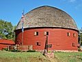
Shortly before Tulsa , in Catoosa , there is a disused amusement park on the edge of the road, where a huge blue whale once attracted visitors and can still be seen. In the small town of Arcadia there is the Round Barn , a restored historic round barn .
The U-Drop-Inn in Shamrock is an Art Deco- style building that once served as a gas station and diner café and made famous by the film Cars , as was the old Brownlee Diner in Glenrio . In Shamrock, the old Magnolia Station has also been preserved - a gas station that has now been restored. Shortly after Amarillo is the Cadillac Ranch - a work of art with ten Cadillacs sunk diagonally into the earth .
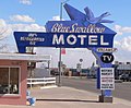
In New Mexico Route 66 passes an old abandoned Whiting Brothers trading post in the tiny town of San Fidel. At the entrance to Tucumcari is the Blue Swallow Motel , whose often-photographed neon sign shows a blue swallow.

Blue whale in Catoosa
The Round Barn in Arcadia

Former underground drop inn in Shamrock

Magnolia Gas station in Shamrock

The abandoned Brownlee Diner in Glenrio

Cadillac Ranch near Amarillo

Old Whiting Brothers Trading Post in San Fidel
The Blue Swallow Motel in Tucumcari


.jpg)


Arizona and California
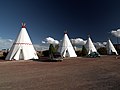
In Holbrook , the Wigwam Motel is located in the style of old Indian tents . Not far from the city, a meteorite struck 50,000 years ago, the crater of which was discovered in 1871. The tracks can still be clearly seen in the Meteor Crater . A little later follows Winslow, who became known through the song Take it Easy by country rocker Eagles .
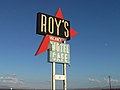
Between Needles and Barstow you come to the longest remaining stretch of the old Route 66 in California. It is also National Trails Highway named because it is a former section of the Old National Trails Road is an even older connection to the west as the route 66. It is in Chambless at the abandoned Roadrunners Retreat restaurant over before you in Amboy to from Roy's Café advertising sign known from numerous commercials . The town of Baghdad is also located on this section , which only consists of a place name sign and a few foundations. The Bagdad Café , known from the film Out of Rosenheim, is a long way off in Newberry Springs in the western Mojave Desert before Barstow. Elmer's Bottle Tree Ranch is on the roadside on the route from Barstow to Victorville ; The California Route 66 Museum , which opened in 1995, is located in Victorville's old town .
Route 66 leads straight through Los Angeles towards the Pacific over Sunset Boulevard and finally ends in Santa Monica on the pier of the marina , whose sign is also known from numerous Hollywood films.
Wigwam Motel in Holbrook

Abandoned Roadrunners Retreat Restaurant
Roy's Café in Amboy

The famous Baghdad Café from the film Out of Rosenheim

Symbol for the west end of Route 66: the Santa Monica Pier


.jpg)

Todays use


After the last sections of the old Route 66 were cut off from through traffic, some residents around the dedicated hairdresser Angel Delgadillo from Seligman founded the Route 66 Association in 1987 , which endeavors to lure tourists to the former main street of America and their forgotten places again to come into the public eye. The organization now has offices in the states of Illinois, Missouri, Kansas, Oklahoma, Texas, New Mexico, Arizona, and California.
A large number of books, websites, films and travel reports about Route 66 and its myth have appeared since then. Route 66 is seen by many as a symbol of freedom, independence, adventure and a spirit of optimism, it stands nostalgically and sentimentally for the "good old days". In some places along its previous route there are souvenir shops, small museums or diner cafés and other original buildings such as former restaurants, gas stations and motels from the heyday of the street, some of which are empty and in some places are left to decay.
Since September 2005, sections of Route 66 in Illinois, New Mexico and Arizona have been designated as Historic Route 66 as a National Scenic Byway . A total of 85 percent of Route 66 is still passable, in Texas even 91 percent. Most of the approximately 3400 kilometers of still passable route is lonely and deserted and is mainly used by the local population. Only the sections near tourist attractions are heavily used.
In the summer of 2001 and 2003, the historic Route 66 route was the venue for the American Solar Challenge , a ten-day solar car race in which over 40 international teams took part.
The 2006 animated film Cars makes reference to Route 66 in many places and shows buildings along the route, such as the U-Drop-Inn Café in Shamrock, Texas or the abandoned Brownlee Diner in Glenrio .
literature
- Dirk Böhm: Route 66 - A myth between Chicago and Los Angeles. In: RoadSide Magazine. Issue 1, EK-Verlag, Freiburg im Breisgau 2009.
- Harley-Davidson Incorporated, Best Western International Inc. (Ed.): Historic Route 66. America's Mother Road. In: Harley-Davidson Great Roads. [Map], Mad Maps, [Milwaukee?] 2007, ISBN 978-1-933911-10-6 ; (Ride 1: Illinois; Ride 2: Missouri, Kansas & Oklahoma; Ride 3: Oklahoma; Ride 4: Texas & New Mexico; Ride 5: Arizona & California. Overview map approx. 1: 4,000,000) (English).
- Holger Hoetzel: Route 66 - Straße der Sehnsucht. 6th edition, (first edition 1992), Ullstein, Frankfurt am Main / Berlin 1996, ISBN 3-550-06558-2 .
- Tom Snyder: Route 66 Traveler's Guide and Roadside Companion. St. Martin's Griffin, New York 2000, ISBN 978-0312644253 (English).
- Michael Wallis: Route 66: The Mother Road. St. Martin's Griffin, New York 2008, ISBN 978-0312281618 (English).
- Jens Wiegand: Route 66 - New ways on old asphalt. In: route guide. 1st edition, Conbook Verlag , Kaarst 2009, ISBN 978-3-934918-28-3 .
- Dres Balmer: Route 66. By bike from Chicago to Los Angeles. 1st edition, Rotpunktverlag, Zurich 2012, ISBN 978-3858694782 .
- Conrad Stein: USA: Route 66 (The journey is the goal). 4th edition, Conrad Stein Verlag, Welver 2012, ISBN 978-3-86686-356-9 .
- Christian Heeb, Margit Brinke, Peter Kränzle: Route 66 - From Chicago to Los Angeles. Bruckmann, 2010, ISBN 978-3-7654-5398-4 .
- Roland Siegloff, Thierry Monasse: On behalf of Route 66 - Three journeys in Europe. Böhland & Schremmer, Berlin 2003, ISBN 978-3-943622-04-1 .
Web links
- Street of Hope - Street of Dreams. A long night on Route 66 - Deutschlandfunk
- The Hackberry General Store - legendary Route 66 museum in Arizona
Individual evidence
- ↑ Historic Route 66 - westbound from Chicago to Gardner Illinois (English). Retrieved December 23, 2016 .
- ^ Official website of Historic Route 66 in Illinois , accessed December 23, 2016.
- ^ Honeymoon with Clark Gable and Easy Rider in: FAZ of February 16, 2012, pp. R6 / R7.
- ^ Roadside Architecture. In: Route 66: The main stream of America. Online at xroads.virginia.edu, accessed December 23, 2016.
- ^ Roadside Attractions. Online at Historic-Route66.de (German), accessed on December 23, 2016.
- ^ Meteor Crater (Barringer Crater). Online at germany66.org (German), accessed December 23, 2016.
- ^ California Historic Route 66 Association website . Route66ca.org, accessed January 14, 2017 .
US Highway 1 |
2 |
3 |
4 |
5 |
6 |
7 |
8 |
9 |
10 |
11 |
12 |
13 |
14 |
15 |
16 |
17 |
18 |
19 |
20 |
21 |
22 |
23 |
24 |
25 |
26 |
27 |
28 |
29 |
30 |
31 |
32 |
33 |
34 |
35 |
36 |
37 |
38 |
40 |
41 |
42 |
43 |
44 |
45 |
46 |
48 |
49 |
50 |
51 |
52 |
53 |
54 |
55 |
56 |
57 |
58 |
59 |
60 |
61 |
62 |
63 |
64 |
65 |
66 |
67 |
68 |
69 |
70 |
71 |
72 |
73 |
74 |
75 |
76 |
77 |
78 |
79 |
80 |
81 |
82 |
83 |
84 |
85 |
87 |
89 |
89A |
90 |
91 |
92 |
93 |
94 |
95 |
96 |
97 |
98 |
99 |
101 |
150 |
151 |
163 |
218 |
400 |
412 |
425
This is a list of the major routes used by the US highway system. Secondary routes can be reached from the article of the respective main route (with identical end digits).
See also: List of United States Highways .