Santa Monica
| Santa Monica | |
|---|---|
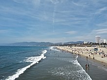
 On Santa Monica Beach |
|
| Location in California | |
| Basic data | |
| Foundation : | 1886 |
| State : | United States |
| State : | California |
| County : | Los Angeles County |
| Coordinates : | 34 ° 1 ′ N , 118 ° 29 ′ W |
| Time zone : | Pacific ( UTC − 8 / −7 ) |
| Residents : | 92,306 (as of 2017) |
| Population density : | 4,313.4 inhabitants per km 2 |
| Area : | 41.2 km 2 (approx. 16 mi 2 ) of which 21.4 km 2 (approx. 8 mi 2 ) is land |
| Height : | 32 m |
| Postcodes : | 90401-90411 |
| Area code : | +1 310/424 |
| FIPS : | 06-70000 |
| GNIS ID : | 1652792 |
| Website : | www.smgov.net |
| Mayor : | Kevin McKeown |
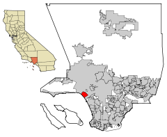
Santa Monica is a city in the west of Los Angeles County in the US state of California on the Pacific Coast . It is located in Santa Monica Bay , south of Pacific Palisades , Malibu and Brentwood , west of Westwood and Sawtelle, and north of Venice . In 2010 the city had 89,736 inhabitants ( 2010 census ). For 2013 the estimate is 92,470 inhabitants. The city is named after Monika von Tagaste , who is venerated as a saint in the Catholic Church.
geography
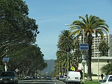
Northwest of Santa Monica are the Santa Monica Mountains , a mountain range rising up to 948 meters. Except on the Pacific coast, the city is surrounded on all sides by the metropolis of Los Angeles .
traffic
The best way to get to Santa Monica is via Los Angeles International Airport, which is about 10 km south, or with the Expo Line of the Los Angeles Metro Rail directly from downtown Los Angeles .
The Interstate 10 (west named Los Angeles' Santa Monica Freeway "- east," San Bernardino Freeway ") ends in Santa Monica near the pier and goes here seamlessly in a northeasterly direction into the Pacific Coast Highway (PCH - Highway 1 ) in Direction Malibu over. Interstate 10 runs east from Santa Monica towards Downtown Los Angeles and crosses Interstate 405 (San Diego Freeway) shortly after the Santa Monica city limits .
Santa Monica has an award-winning bus network; the Big Blue Bus uses modern vehicles and runs comparatively frequently by southern California standards.
Santa Monica also has a local airport, Santa Monica Airport for charter flights, private and sport aircraft.
Major arteries in Santa Monica when viewed from the coast are San Vicente Boulevard, Montana Avenue, Wilshire , Santa Monica, and Ocean Park Boulevard. Parallel to the coast, these are the Pacific Coast Highway, Ocean Avenue / Neilson Way as well as Lincoln Boulevard (which is also Pacific Coast Highway 1 in a south-easterly direction) and 26th Street. Historic Route 66 also ends in Santa Monica - on the Santa Monica Pier .
history
The city of Santa Monica, initially founded as a small Spanish settlement, became Mexican from 1828 to 1848, only to become American. The town, which had fewer than 3,000 inhabitants around 1900, was expanded by businessmen John Percival Jones and Robert Baker in 1875. The rectangular settlement was then bordered by Ocean Avenue on the coast, Montana Avenue in the northwest, Colorado Avenue in the southeast and inland by 26th Street. Summer residence lots on the first line of the beach were sold for $ 300. Behind it, on Second Street, were the first stone buildings. The oldest house still preserved today is the Rapp Saloon, in which the German-born William Rapp ran the “Los Angeles Beer Garden”. Robert Baker had a 27-kilometer-long railway line built between Los Angeles and Santa Monica in just ten months, which enabled the town to expand rapidly. In 1887, the Arcadia Hotel opened, which at the time was the finest beach establishment in Southern California. In the years to come, Santa Monica developed into a bathing and entertainment destination for the greater Los Angeles area. The main attraction was the Santa Monica Pier.
Attractions
The Santa Monica Pier , which was built in 1909, is one of the most famous attractions in the city. In addition to the small Pacific Park amusement park with roller coaster ( Santa Monica West Coaster ) and Ferris wheel, it also houses numerous restaurants and shops. In the Looff Hippodrome building, at the beginning of the pier, there has been an old horse carousel since 1947. The entrance to the pier on Ocean Avenue is a white and blue gate that is illuminated with neon lights at night .
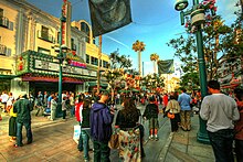
The Third Street Promenade , with approximately 400 meters in length, one of the few pedestrian areas in the greater Los Angeles area , covers three blocks between the mall Santa Monica Place and Wilshire Blvd. Its proximity to the Santa Monica Pier makes it a popular spot for tourists and locals alike. In the evenings, many street performers entertain visitors along the three-block shopping area. The south end of Third Street Promenade is completed by the Santa Monica Place shopping mall , designed by Frank Gehry .
The "Rapp Saloon" is located in the parallel street, Second Street. After the city was founded, William Rapp, of German descent, ran the "Los Angeles Beer Garden" in the one-story house; later the town hall was temporarily housed here. The small building is the last remaining house from the founding year 1875 and today one of the landmarks of Santa Monica.
Healthcare
Health care is provided by two hospitals, both of which are undergoing a multi-year renovation phase. The Saint John's Health Center was named the best municipal hospital of the American West Coast. The nearby UCLA Medical Center , a former city hospital, is now a branch of UCLA's University Hospital in Westwood , which is one of the top 10 US hospitals.
Churches
The largest local church is the Roman Catholic St. Monica Catholic Church at the intersection of 725 California Avenue and 7th Street. The services are broadcast as a live stream on the Internet. There are, however, many other churches as well.
Population and demographics
A significant minority of the population is of Meso or Latin American descent. However, the majority of the population is non-Hispanic whites, which distinguishes Santa Monica from both the city and Los Angeles County .
The 89,736 residents of Santa Monica, found in the 2010 census , lived in 46,917 households; including 17,929 families. The population density was 4117 per km². 50,912 residential units were recorded in the village. Among the population, 77.6% were white (including 70.1% non-Hispanic whites), 3.9% African American , 0.4% American Indian , 9.0% Asian, and 4.6% of other races ; 4.4% said they belonged to several races. Regardless of race, 13.1% of the population was Hispanic or Latino .
Of the 46,917 households, 16.7% had children under the age of 18; 27.9% were married couples living together. 48.4% of the households were single households. The average household size was 1.87 and the average family size was 2.79.
The population was divided into 14.0% under 18 years of age, 7.2% from 18 to 24 years of age, 36.3% from 25 to 44 years of age, 27.6% from 45 to 64 years of age and 15.0% from 65 years of age or older. The median age was 40.4 years.
The median household income in 2000 was $ 50,714 and the median family income was $ 75,989. The per capita income in Santa Monica was $ 42,874. 10.4% of the population lived below the poverty line. According to an extrapolation for 2014, the values for household income rose to $ 74,534 and family income to $ 113,956. In 2010, the median family income was $ 72,271, with 11.3% living below the poverty line.
The following table lists the population of Santa Monica since 1880, according to the results of the 1880-2010 census by the United States Census Bureau :
|
|
media
KCRW-FM (also known as "Public Radio for Southern California") broadcasts from Santa Monica on the FM frequency 89.9 MHz. The station is operated by Santa Monica College and is one of the strongest partners of National Public Radio in Southern California . The station reaches an audience of 550,000 weekly.
Trivia
Santa Monica is a city independent of Los Angeles and therefore has its own administration and police force. In Santa Monica there are therefore numerous regulations that differ from those in Los Angeles. Pedestrians are prohibited from crossing the streets away from pedestrian crossings or traffic lights.
Due to the proximity to the film industry, locations of Santa Monica appear again and again in a wide variety of films. The entrance to Santa Monica Pier was a turning point for Forrest Gump on his travels across the United States. On the pier is a restaurant owned by the Bubba Gump Shrimp Company , which was inspired by the movie. The horse carousel on the pier was the scene of a chase and shootout in The Net . A BigBlueBus from the public transport company was Speed's arena . One scene in Terminator 2 took place at the Santa Monica Place mall. The Baywatch TV series was partly played on the beach and on the pier in Santa Monica.
In the Wii U game Lego City Undercover, there is a reference to the Santa Monica Pier in the Paradise Sands district.
The British band The Sweet released the song Santa Monica Sunshine on their first album Funny How Sweet Co-Co Can Be in 1971 .
Town twinning
Santa Monica has twinned cities with the German city of Hamm ( North Rhine-Westphalia ) and the Hechuan district of the city of Chongqing , People's Republic of China .
Personalities
sons and daughters of the town
- Shirley Temple (1928-2014), actress
- Frank Gifford (1930-2015), American football player and sports presenter
- Robert Redford (born 1936), actor, director and producer
- Geraldine Chaplin (born 1944), actress
- Richard Hatch (1945–2017), actor and writer
- Mark Mancina (* 1957), composer
- Lorenzo Lamas (born 1958), actor
- Joseph Williams (born 1960), rock singer
- Scott Davis (born 1962), tennis player
- Jack Black (* 1969), actor, comedian and singer with the band Tenacious D.
- Sara Gilbert (* 1975), actress
- Tobey Maguire (born 1975), actor
- Christina Ricci (* 1980), actress
- Tyler Posey (born 1991), actor
Personalities with a relationship to the city
- Rudolf Carnap (1891–1970), philosopher and science theorist
- Elzie Segar (1894–1938), comic artist and the inventor of the character of Popeye
- Richard Maibaum (1909–1991), screenwriter
- Sidney Luft (1915-2005), film producer
- Peter Hobbs (1918-2011), actor
- Walter Arlen (* 1920), composer and music critic
- Frank Gehry (* 1929), Canadian-American architect and designer
- John Baldessari (1931-2020), artist
- Don Bachardy (* 1934), artist and art collector
- Troy Donahue (1936-2001), actor
- Carole Caldwell Graebner (1943-2008), tennis player
- Dan Harrington (born 1945), poker player
- Paul Haggis (* 1953), Canadian screenwriter, producer and director
- Edwin Kantar (* 1932), bridge player
- Chris Penn (1965-2006), actor and brother of actor Sean Penn
- Charlie Sheen (born 1965), actor
- Christy Hemme (* 1980), actress, model, singer and wrestler
- Jenna Marbles (* 1986), YouTube video producer
- Clay Thompson (born 1992), tennis player
Web links
Individual evidence
- ↑ Santa Monica in Los Angeles (California). In: city population. Accessed May 1, 2019 .
- ↑ a b c d e George Szpiro: Santa Monica lives from its reputation - the boom in tourism in the Californian city despite a small number of attractions . In: Neue Zürcher Zeitung . No. 184 . Zurich August 12, 2013, p. 5 .
- ↑ a b Torsten Meyer: Journey through the city of angels - story (s) from Los Angeles . 2016. ISBN 978-3-7386-2083-2
- ↑ St. Monica
- ^ Churches in Santa Monica
- ↑ a b 2010 census results for Santa Monica at quickfacts.census.gov. Retrieved December 30, 2014.
- ↑ Monica city, California / POPULATION / DECENNIAL_CNT Santa Monica city, California , data sheet with the results of the 2000 census at factfinder.census.gov .
- ↑ Monica city, California / INCOME / MEDIAN_HH_INCOME Santa Monica city, California. S1901. Income in the Past 12 Months (In 2007 Inflation-Adjusted Dollars)
- ^ Chongqing Municipal Government


