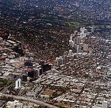
Wilshire Boulevard

The Wilshire Boulevard [ 'wilʃəɻ' bu̇ləˌvard ] ( ) is one of the main east-west axis in Los Angeles . It connects Santa Monica with Beverly Hills and downtown Los Angeles . The main street was named after Henry Gaylord Wilshire (1861-1927), a large landowner , publisher and socialist . Wilshire had transferred the area to the Los Angeles City Council in 1895 with the stipulation that the main thoroughfare to be built should bear his name.
Description and location
The Wilshire Boulevard extends over a length of 26 kilometers from the Grand Avenue in Downtown Los Angeles to Ocean Avenue in Santa Monica . A number of skyscrapers line Wilshire Boulevard , including Aon Center , once the tallest building in the city and currently the tallest building in the Wilshire Grand Tower . The main building of the Academy of Motion Picture Arts and Sciences with the integrated Samuel Goldwyn Theater is located at “8949 Wilshire Boulevard” in Beverly Hills .
The office building built by Edward Durell Stone in 1962 for the Perpetual Savings and Loan Association (9720 Wilshire Blvd., corner of McCarty Drive; now Pacific Mercantile Bank ) is also architecturally valuable .
The central section of Wilshire Boulevard , Miracle Mile , is between Fairfax Avenue and La Brea Avenue . The Los Angeles County Museum of Art (LACMA) and the Page Museum with the La Brea Tar Pits are located there in Hancock Park .
The boulevard has been expanded to four to ten lanes since the 1980s and has partially structurally separate carriageways.
gallery
Wilshire Boulevard in Koreatown
Wilshire Boulevard in Brentwood (Los Angeles)
Segment of the Berlin Wall , installed by the Wende Museum , in front of the 5900 Wilshire Boulevard skyscraper in Los Angeles
Literature and Sources
- Kevin Roderick, J. Eric Lynxwiler: Wilshire Boulevard: The Grand Concourse of Los Angeles. Los Angeles, 2005. ISBN 1-883318-55-6 .
Web links
- J. Eric Lynxwiler: Wilshire Boulevard: The Grand Concourse of Los Angeles. Google Talk recording from June 26, 2006
Individual evidence
Coordinates: 34 ° 3 '36 " N , 118 ° 21' 36" W.


