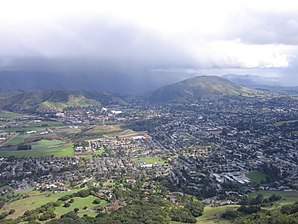
San Luis Obispo
| San Luis Obispo | |
|---|---|
 San Luis Obispo |
|
 seal |
 flag |
| Location in San Luis Obispo County | |
| Basic data | |
| Foundation : | 1772 |
| State : | United States |
| State : | California |
| County : | San Luis Obispo County |
| Coordinates : | 35 ° 16 ′ N , 120 ° 40 ′ W |
| Time zone : | Pacific ( UTC − 8 / −7 ) |
|
Inhabitants : - Metropolitan Area : |
47,536 (as of 2016) 282,887 (as of 2016) |
| Population density : | 1,722.3 inhabitants per km 2 |
| Area : | 27.7 km 2 (approx. 11 mi 2 ) of which 27.6 km 2 (approx. 11 mi 2 ) is land |
| Height : | 71 m |
| Postal code : | 93401 |
| Area code : | +1 805 |
| FIPS : | 06-68154 |
| GNIS ID : | 1652788 |
| Website : | www.slocity.org |
| Mayor : | Dave Romero |
San Luis Obispo is a city in San Luis Obispo County in the US state of California , United States , with 45,119 residents ( 2010 census ). It is the seat of the county seat of the county . The urban area has a size of 28.1 km². The city has one airport, the San Luis Obispo County Airport (KSBP / SBP). California Polytechnic State University is in the city .
The metropolitan region that forms San Luis Obispo together with the cities of Arroyo Grande and El Paso de Robles has almost 280,000 inhabitants.
sons and daughters of the town
- Stephanie Brown Trafton (* 1979), discus thrower, 2008 Olympic champion
- Wolfgang Gartner (* 1982; civil name: Joey Youngman), electro house producer and DJ
- Jenaveve Jolie (* 1984), porn actress
- Zac Efron (born 1987), actor
- Chris Seitz (* 1987), soccer player
- Kami Craig (* 1987), water polo player
Web links
Commons : San Luis Obispo - Collection of Images, Videos and Audio Files
- Tourism info about 'San Luis Obispo County'
- Airport Information about San Luis Obispo County Airport from the Airport Guide
Individual evidence
- ↑ Metropolitan Regions (USA): Metropolitan Regions - Population Statistics, Charts and Map. Retrieved February 7, 2018 .
- ↑ Biography on the Wolfgang Gartner homepage ( memento of the original dated December 14, 2011 in the Internet Archive ) Info: The archive link was inserted automatically and has not yet been checked. Please check the original and archive link according to the instructions and then remove this notice.

