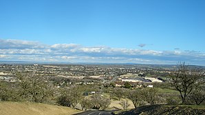
El Paso de Robles
| El Paso de Robles | ||
|---|---|---|
| Nickname : Paso Robles / 'Paso' | ||
 |
||
| Location in California | ||
|
|
||
| Basic data | ||
| Foundation : | March 11, 1889 | |
| State : | United States | |
| State : | California | |
| County : | San Luis Obispo County | |
| Coordinates : | 35 ° 38 ′ N , 120 ° 40 ′ W | |
| Time zone : | Pacific ( UTC − 8 / −7 ) | |
|
Inhabitants : - Metropolitan Area : |
29,498 (as of 2007) 41,249 (as of 2007) |
|
| Population density : | 572.1 inhabitants per km 2 | |
| Area : | 51.56 km 2 (approx. 20 mi 2 ) of which 51.56 km 2 (approx. 20 mi 2 ) is land |
|
| Height : | 242 m | |
| Postal code : | 93446 | |
| Area code : | +1 805 | |
| FIPS : | 06-22300 | |
| GNIS ID : | 254139 | |
| Website : | prcity.com | |
| Mayor : | Frank Mecham | |
El Paso de Robles (short form: Paso Robles) is an American city in southern California in San Luis Obispo County . It is located on Highway 101. The city has about 29,000 inhabitants (as of 2007) on an area of 44.9 km².
The city is the headquarters of the Firestone Walker Brewing Company , whose beer is also sold in Germany .
The local airport (Paso Robles Municipal Airport) has the IATA code: PRB.
sons and daughters of the town
- Elena Verdugo (1925-2017), actress
Web links
Commons : Paso Robles, California - Collection of images, videos, and audio files
