Glenrio
| Glenrio | ||
|---|---|---|
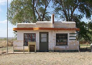
 The abandoned Brownlee Diner , also known as Little Juarez Cafe known |
||
| Location in Texas | ||
|
|
||
| Basic data | ||
| Foundation : | 1906 | |
| State : | United States | |
| State : | Texas | |
| Counties : |
Quay County Deaf Smith County |
|
| Coordinates : | 35 ° 11 ′ N , 103 ° 3 ′ W | |
| Time zone : | Central ( UTC − 6 / −5 ) | |
| Residents : | 5 (status: 2000) | |
| Height : | 1175 m | |
| Postal code : | 88434 | |
| FIPS : | 48-29864 | |
| GNIS ID : | 915829 | |
 Route 66 in Glenrio between Texas and New Mexico |
||
Glenrio is a small, almost completely deserted place on the old Route 66 , right on the border between the US states of Texas and New Mexico . It belongs to both Quay County in New Mexico and Deaf Smith County in Texas.
history
In 1906, Glenrio was founded as a charging station for the Rock Island and Gulf Railway from Chicago . The place name is made up of the Scottish term "glen" (small valley) and the Spanish "rio" (river). In 1920 Glenrio had a hotel, an agricultural machinery business, several supermarkets, gas stations and cafes. The local newspaper, the Glenrio Tribune , appeared from 1910 to 1934. The post office was part of New Mexico, but the mail was delivered in an office in Texas.
With the construction of Route 66 in 1926, which ran right through the town, Glenrio became an important stop for travelers on the "Mother Road" for decades. The place is only ten miles (16 kilometers) east of the geographic center of Route 66 in Adrian, Texas , so it marks practically half of the route between Chicago and Los Angeles.
The section of Route 66 in Glenrio was the location of a well-known motel among travelers with the sign "First Motel in Texas" on the west and "Last Motel in Texas" on the east. The post office, a Phillips 66 gas station, a diner called “Little Juarez Cafe” and the “Courtyard Motel” also belonged to the “border crossing point” between Texas and New Mexico. There were no bars on the Texan side, as no alcohol was served in Deaf Smith County, and no gas station on the New Mexico side because of the higher gasoline tax in that state.
Glenrio also marked the transition between two time zones from "Central Time" ( UTC-6 ) in Texas to "Mountain Time" ( UTC-7 ), which is valid in New Mexico.
After the town was bypassed by Interstate Highway 40 in 1973, Glenrio suffered the same fate as many other places on Route 66 , which were cut off from their source of income almost overnight and fell into insignificance.
Almost all residents left the place. There are only a few houses left. After there were only two residents left in 1985, the post office was closed. In 2000 there were five residents in Glenrio.
In the area on the former Route 66, some decaying remains of the motels, a diner and a gas station can be seen.
Some scenes from the 1940 film The Fruits of Wrath were shot in Glenrio. At that time the place had 30 inhabitants.
Visitor center
On June 25, 2008, the state of New Mexico opened the Glenrio Visitor Information Center on Interstate 40 on the Texas border. There is a media center, animal enclosure, wireless internet access and an information desk. Since one million visitors per year are expected, ecological aspects were taken into account. The wastewater will be recycled and a small wind power plant will produce 20 percent of the energy that the visitor center consumes.
Web links
- Glenrio ( English ) In: Geographic Names Information System . United States Geological Survey . Retrieved February 8, 2011.
- Texas online - Glenrio
- Images from Glenrio
swell
- ↑ Glenrio Welcome Center officially opened ( Memento of February 13, 2012 in the Internet Archive )
- Michael Wallis: Route 66: The Mother Road, Griffin (2008) ISBN 0-312-28161-7 .
- Holger Hoetzel: Route 66: Straße der Sehnsucht , Ullstein; (1992) ISBN 3-550-06558-2 .
- Tom Snyder: Route 66: Traveler's Guide and Roadside Companion Griffin (2000) ISBN 0-312-25417-2 .

