Chain of Rocks Bridge
Coordinates: 38 ° 45 ′ 38 " N , 90 ° 10 ′ 35" W.
| Chain of Rocks Bridge | ||
|---|---|---|
| The Chain of Rocks Bridge, listed in the NRHP since 2006 | ||
| use | Pedestrian and bicycle traffic | |
| Convicted | Former Route 66 | |
| Crossing of | Mississippi River | |
| place | Madison , Illinois to St. Louis , Missouri | |
| Entertained by | Trailnet | |
| construction | Gerber girder - truss bridge | |
| overall length | 1632 m | |
| width | 7 m | |
| Longest span | 213 m | |
| building-costs | $ 3 million | |
| opening | 1929 | |
| closure | 1970 (for motor vehicle traffic) | |
| location | ||
|
|
||
| Above sea level | 122 m | |
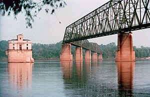
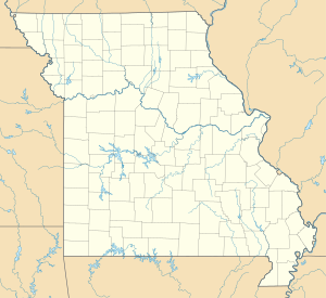
The Chain of Rocks Bridge crosses the Mississippi between the north of the city of St. Louis and Madison in the county of the same name in Illinois on the east bank of the river. The peculiarity of the structure is the bend that the bridge has in the middle of the river. The bridge used to cross Route 66 , but is now only open to pedestrians and cyclists.
The name is derived from below the bridge occurring "Chain of Rocks" (Eng .: rocky hills ) shallows mentioned from which impair the navigability at this point strongly. For this reason, the Chain of Rocks Canal was built east of the river .
history
In 1894, the first St. Louis waterworks was built in the Chain of Rocks area . The water tapping points of the Chain of Rocks Water Treatment Facility , which is still the largest waterworks in St. Louis today, are in the immediate vicinity of the bridge.
In 1929, the privately financed bridge was opened next to the waterworks and led the then Route 66 over the Mississippi. In order to pay the construction costs, a toll was initially levied for the passage of the bridge. In the late 1930s, several bypasses and with them more bridges were opened. Toll collection was discontinued in 1966. In the same year, the New Chain of Rocks Bridge , a little further north, was opened, over which the Interstate 270 crosses the river as the northern bypass of St. Louis. In 1970 the Chain of Rocks Bridge was closed.
In 1998 the bridge, now owned by the City of Madison, was rented from Trailnet. This group of cycling enthusiasts raised $ 4.5 million to renovate and maintain the bridge for pedestrian and bicycle traffic.
In the course of the increasing tourist importance of the former Route 66, the tourist attraction at the bridge also increased. In 2006 the Chain of Rocks Bridge was added to the National Register of Historic Places under number 06001091 .
Be careful when visiting the Chain of Rock Bridge. The area around the bridge is known for drug trafficking and theft of cars. The parking lot on the St. Louis side was therefore canceled again, the parking area on the Illinois side greatly reduced.
Individual evidence
- ↑ a b Extract from the National Register of Historic Places - No. 06001091. Retrieved July 21, 2012
- ↑ City of St. Louis Water Division - Chain of Rocks Water Treatment Facility ( Memento of the original from February 9, 2011 in the Internet Archive ) Info: The archive link was automatically inserted and not yet checked. Please check the original and archive link according to the instructions and then remove this notice. Retrieved July 21, 2012
- ↑ Trailnet Accessed July 21, 2012
- ↑ Bridgehunter.com : Old Chain of Rocks Bridge , accessed July 22, 2012

