US Highway 3
| map | |
|---|---|

|
|
| Basic data | |
| Overall length: | 277 mi / 446 km |
| Opening: | 1926 |
| States: |
Massachusetts New Hampshire |
| Starting point: |
|
| End point: |
|
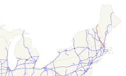
The US Highway 3 (short US 3 ) is a United States highway in the United States . It begins on Massachusetts Route 2A or Route 3 in Cambridge and ends after 446 kilometers at the Canadian border near Chartierville , where it becomes Quebec Route 257 .
In New Hampshire , sections of the highway are known as the Daniel Webster Highway . US 3 was expanded as a freeway between the cities of Burlington in Massachusetts and Nashua in New Hampshire. It is also part of the Everett Turnpike over a length of 10.8 kilometers .
course
Massachusetts
Beginning in downtown Cambridge, the highway runs through suburbs to an intersection with Interstate 95 and Massachusetts Route 128 in southwest Burlington. From this cross it is developed as a freeway to Nashua. To the south of Lowell, US 3 crosses Interstate 495 . North of Tyngsborough , the highway reaches the New Hampshire border.
New Hampshire
From the border it forms the first section of the Everett Turnpike for eleven kilometers to Nashua , which ends in Concord after 64 kilometers . From Nashua to Concorde, US Highway 3 runs parallel to the Merrimack River , the Everett Turnpike and, from Manchester, also to Interstate 93 . Until shortly before the city of Franconia , the US 3 meets the I-93 again and again, until it runs from there in a northeastern direction. North of the Connecticut Lakes , US Highway 3 then reaches the Canadian border between Third Lake and Chartierville.
Web links
- US Highway Ends (English)
- Northwest Expressway (English)
- AARoads New Hampshire (English)
