Cambridge, Massachusetts
| Cambridge | ||
|---|---|---|
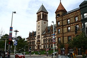
 Cambridge City Hall |
||
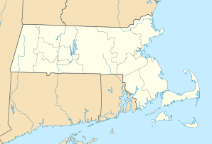
| Location in Massachusetts | ||
|
|
||
| Basic data | ||
| Foundation : | 1636 | |
| State : | United States | |
| State : | Massachusetts | |
| County : | Middlesex County | |
| Coordinates : | 42 ° 22 ′ N , 71 ° 6 ′ W | |
| Time zone : | Eastern ( UTC − 5 / −4 ) | |
| Residents : | 113,630 (as of 2017; estimate) | |
| Population density : | 6,804.2 inhabitants per km 2 | |
| Area : | 18.5 km 2 (approx. 7 mi 2 ) of which 16.7 km 2 (approx. 6 mi 2 ) is land |
|
| Height : | 12 m | |
| Postcodes : | 02138-02142 | |
| Area code : | +1 617, 857 | |
| FIPS : | 25-11000 | |
| GNIS ID : | 0617365 | |
| Website : | www.cambridgema.gov | |
| Mayor : | Marc C. McGovern (2018-2019) | |

Cambridge [ ˈkeɪmbrɪdʒ ] is a city in the US state of Massachusetts and a suburb of Boston . It was named in honor of the English city of Cambridge , where the city's founding fathers studied ( Cambridge University ). Cambridge is known through Harvard University and the Massachusetts Institute of Technology , two of the most prestigious universities in the world. According to the last census in 2010, the population was 105,201 (2017 estimate: around 114,000).
Cambridge is located in Middlesex County in the US state of Massachusetts. The district was abolished in 1997 and only exists today as a geographical description. Cambridge and Lowell were the county towns of Middlesex Counties.
Over the city
The population structure is diverse, with a wide variety of people living in Cambridge - from Harvard professors to the poorest immigrants . This diversity adds to the liberal atmosphere and can in some ways be compared to the university town of Berkeley , California . Because of its famous liberal politics, the city is often called "The People's Republic of Cambridge"; Political organizers regularly gather at Harvard Square Tube Station.
Cambridge has been called "The City of Squares", most likely because most of its main intersections are known as "Squares". Very few "squares" have four sides. Each of these "squares" functions as a kind of neighborhood center. This includes:
- Kendall Square , shaped by the intersection of Broadway, Main Street and Third Street. Directly over the "Longfellow Bridge" from Boston, at the eastern end of the MIT campus. It is served by the MBTA Red Line subway. A thriving biotechnology industry has developed in the area, in large part due to the energetic efforts of MIT students.
- Central Square shaped by the intersection of Massachusetts Avenue , Prospect Street, and Western Avenue. This is possibly the closest area of Cambridge to downtown. It is also known for its variety of ethnic restaurants. In the late 1990s, the area was rather run down; only in the last few years has it become more sophisticated. Lafayette Square, formed by the intersection of Massachusetts Avenue, Columbia Street, Sidney Street, and Main Street, is considered part of the Central Square area.
- Harvard Square shaped by the intersection of Massachusetts Avenue, Brattle Street and JFK Street. This is the seat of Harvard University , the oldest university in the United States. Like Central Square, Harvard Square has only gotten more elegant in recent years. It contains many interesting shops and has the highest density of bookstores in the country.
- Porter Square , about a mile up Massachusetts Avenue from Harvard, formed by the intersection of Massachusetts Avenue and Somerville Avenue. It is served by the MBTA Red Line subway.
- Inman Square , at the intersection of Cambridge Street and Hampshire Street in East Cambridge.
- Lechmere Square , at the intersection of Cambridge Street and First Street, by the Galleria shopping center. It is served by the MBTA Green Line underground.
Even if you often see printed references to the "Boston / Cambridge Area", Cambridge prefers to preserve its own identity. This is entirely appropriate as Cambridge has a large number of jobs and some parts of the city are even more urban than parts of Boston .
geography
Cambridge is bordered by Boston to the east and south, Somerville and Arlington to the north, and Watertown and Belmont to the west .
population
As of the 2000 census, 101,355 residents, 42,615 households and 17,599 families reside in the city. The population density is 6,086.1 / km 2 (15,766.1 / mi 2 ). There are 44,725 residential wings with an average density of 2685 / km 2 (6957.1 / mi 2 ). 68.10% of the city's population is White, 11.92% African American, 0.29% Native American, 11.88% Asian, 0.08% Pacific, 3.19% of other origins, and 4.56% of two or more Descended from ethnic groups. 7.36% of the population are Hispanics or Latinos of any origin.
There are 42,615 households, of which 17.6% have children under the age of 18 living with them, 29.1% are married couples living together, 9.7% have a female head of the household and 58.7% are non-families. 41.4% of all households are individuals and 9.2% of all households only have one person who is 65 years of age or older. The average household size is 2.03 and the average family size is 2.83.
In the city, the age structure of the population is scattered with 13.3% under 18 years, 21.2% from 18 to 24, 38.6% from 25 to 44, 17.8% from 45 to 64 and 9.2% with 65 years of age or more. The average age is 30 years. For every 100 women there are 96.1 men. For every 100 women aged 18 or older, there are 94.7 men.
The median income for a household in the city is $ 47,979 and the median income for a family is $ 59,423. Men have a median income of $ 43,825 versus $ 38,489 for women. The per capita income for the city is $ 31,156. 12.9% of the population and 8.7% of families are below the poverty line. Of all people living in poverty, 15.1% are under 18 years of age and 12.9% are 65 years of age or older.
| year | Residents 1 |
|---|---|
| 1980 | 95,322 |
| 1990 | 95,802 |
| 2000 | 101,322 |
| 2010 | 105.201 |
| 2016 | 110,651 |
Law and government
Cambridge has a nine-member city council and a six-member school committee. City councilors and committee members are elected every two years using the single transferable vote (STV) system. Since the dissolution of the New York City Community School Boards in 2002, the council has been unusually the only board of directors in the United States to use STV.
The mayor is elected by and from the city council, serves as the chairman of the city council meetings and also sits on the school committee. Still, the mayor is not the city's chief executive. This role is more likely to be assumed by the City Manager, who is appointed by the City Council.
traffic
Cambridge is served by the subway line Red Line of the Massachusetts Bay Transportation Authority (MBTA), this also represents the connection with the neighboring city of Boston. Within the city the four lines of the trolleybus Cambridge and various bus lines operate , also for the The MBTA is responsible for road transport.
Colleges and universities
- Harvard University
- Massachusetts Institute of Technology
- HULT International Business School
- Lesley College
- Cambridge College
- Radcliffe College ( Harvard University )
Town twinning
Cambridge has active partnerships with seven cities:
|
sons and daughters of the town
- Eleanor Hallowell Abbott (1872–1958), poet, novelist and children's book author
- Fred Allen (1894–1956), actor, comedian and radio host
- Leroy Anderson (1908–1975), composer
- Jonathan Beckwith (* 1935), biochemist, microbiologist and geneticist
- Herbert Berliner (1882–1966), Canadian music producer and inventor
- Phil Brown (1916-2006), actor
- Bhumibol Adulyadej (1927–2016), King of Thailand
- Charles Bickford (1891-1967), actor
- Noah Bless (* 1968), jazz musician
- Percy Williams Bridgman (1882–1961), physicist and Nobel Prize winner
- Paul Broadnax (1926–2018), jazz musician
- EE Cummings (1894–1962), poet and writer
- Matt Damon (born 1970), actor
- Robert Deeley (born 1946), Catholic Bishop of Portland
- Bill Elgart (* 1942), jazz drummer
- Charles Eliot (1859–1897), landscape architect
- Nnenna Freelon (* 1954), jazz singer
- David Gilmore (* 1964), jazz musician
- Marque Gilmore , percussionist and drummer
- Paul Michael Glaser (* 1943), actor
- William Caspar Graustein (1888–1941), mathematician
- Stephen Greenblatt (* 1943), literary scholar
- Jerry Grossman (born 1950), cellist
- William Dodd Hathaway (1924-2013), politician
- Robert Herrick (1868–1938), writer and acting governor of the US Virgin Islands
- George L. Hersey (1927–2007), art and architecture historian
- Edward Burlingame Hill (1872–1960), composer
- Johnny Hodges (1906–1970), swing alto saxophonist
- Oliver Wendell Holmes, Sr. (1809-1894), American doctor and writer
- Anna Hyatt Huntington (1876–1973), sculptor
- Joe Hyams (1923-2008), journalist and writer
- Louis Francis Kelleher (1889–1946), auxiliary bishop in Boston
- Steve Leach (* 1966), ice hockey player and coach
- Neil Leonard (1927–2012), author and professor
- Richard Lourie (* 1940), writer, translator and publicist
- James Russell Lowell (1819-1891), poet, essayist, editor, professor, and diplomat
- Jessica Lurie (* 1967), jazz musician
- Franc Luz (born 1950), film actor
- Frank Lynes (1858–1913), composer, organist and music teacher
- Fred MacIsaac (1886-1940), science fiction writer
- Raphe Malik (1948–2006), free jazz trumpeter
- Anne McCaffrey (1926–2011), science fiction writer
- Erica McDermott (born 1973), actress
- Douglass North (1920–2015), economist and economic historian
- Charles S. Peirce (1839–1914), mathematician, philosopher and logician
- Edward Charles Pickering (1846–1919), astronomer and physicist, brother of William Henry Pickering
- Douglas Preston (born 1956), writer
- Richard Preston (born 1954), writer
- Alex Rocco (1936–2015), actor
- Edward Royce (1886–1963), composer and music teacher
- Lloyd S. Shapley (1923–2016), economist and mathematician, Nobel Prize winner
- Edmund Ware Sinnott (1888–1968), botanist and philosopher of biology
- Russi Taylor (1944-2019), voice actress
- Sam Waterston (born 1940), actor
- Arthur Whiting (1861–1936), composer, organist and pianist
Web links
swell
- ↑ Single transferable vote ( Memento from March 6, 2005 in the Internet Archive )
- ↑ City of Cambridge - Sister Cities Overview , accessed June 17, 2018


