Cambridge
| City of Cambridge | ||
|---|---|---|
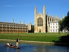
| King's College with chapel | ||
| Coordinates | 52 ° 12 ′ N , 0 ° 7 ′ E | |
| OS National Grid | TL450588 | |
|
|
||
| Residents | 131,799 (as of 2016) | |
| surface | 115.65 km² (44.65 mi² ) | |
| Population density: | 1140 inhabitants per km² | |
| administration | ||
| ZIP code section | CB1 - CB5 | |
| prefix | 01223 | |
| Part of the country | England | |
| region | East of England | |
| Shire county | Cambridgeshire | |
| ONS code | 12UB | |
| Website: www.cambridge.gov.uk | ||
Cambridge [ ˈkeɪmbɹɪdʒ ] is an English city in the United Kingdom and the capital of the county of Cambridgeshire with a population of about 123,800, including about 24,500 students.
Famous are the University of Cambridge , the Gothic chapel and choir of King's College , the university library and Trinity College . The titles of Duke , Marquess and Earl of Cambridge are named after Cambridge .
geography
Geographical location
Cambridge is located on the River Cam about 80 km northeast of London in east England .
City structure
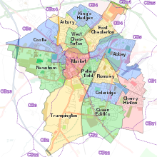
Cambridge is divided into 14 wards for electoral purposes : Abbey, Arbury, Castle, Cherry Hinton, Coleridge, East Chesterton, King's Hedges, Market, Newnham, Petersfield, Queen Edith's, Romsey, Trumpington, and West Chesterton.
climate
The warmest month in the annual mean is July with 17 ° C, the coldest month is January with 3.5 ° C. The annual mean is 9.9 ° C. The total precipitation is 558 mm.
history

The first settlements in the area of what is now Cambridge existed before the age of the Roman Empire. The earliest evidence of settlement, a collection of hunting weapons, comes from the late Bronze Age (1000 BC). There is further archaeological evidence of a Belgian tribe settling in Castle Hills in the first century AD.
With the Roman invasion of Britain (c. 40 AD), Cambridge became an important military post to defend the Cam . In addition, the Via Devana , which connected Colchester ( Essex ) with the northern garrisons in Chester, crossed the Cam here. The Roman name of this settlement is believed to have been Duroliponte . The settlement remained a regional center for the next 350 years. To this day, many Roman roads and fortifications can be found around Cambridge, such as Great Chesterford .
After the retreat of the Romans, the area around Castle Hill was conquered by the Angles , whose grave goods were found in this area. During the Anglo-Saxon period, Cambridge benefited from the very good trade routes within the city. These enabled safer and easier traffic through the difficult to travel Fens . However, in the 7th century, travelers to nearby Ely reported a sharp drop in trade. The settlement of Grantebrycge is mentioned in Anglo-Saxon chronicles , the first reference to a bridge in Cambridge. In 875, the Anglo-Saxon Chronicles recorded the arrival of the Vikings in Cambridge. The brisk trade of the Vikings led to a renewed rapid growth of Cambridge. During this time, the city center shifted from Castle Hill on the left bank of the river to what is now Quayside on the right bank of the river. After the end of the Viking era, the Saxons briefly regained power in Cambridge and built St. Benet's Church in 1025.
Two years after the Norman conquest of England, William the Conqueror had Cambridge Castle built on the highest point in the city. Like the rest of the kingdom, Cambridge was under the control of the king and his deputies. The distinctive Round Church in the city center was built during this period. In the age of the Normans the name is recorded in the form of Grentabrige or Cantebrigge , the name of the river as Granta . The name of the town continued to change to what is now Cambridge, while the river was still further known as Granta . Even today, the cam is sometimes still referred to as a Granta. The University of Cambridge often uses the adjective neolateinische Cantabrigiensis (Cambridge).
During the Second World War , several heavy and light attacks were carried out on the Royal Air Force airport in Duxford during the Battle of Britain . Parts of the city of Cambridge were also hit. On September 23, 1940, in retaliation for an air raid on Heidelberg in the night of September 19 to 20, 1940, the first attack on Cambridge took place. The bombing of the German air force destroyed 7% of the buildings from 1940 to 1941.
Attractions
- King's College College, Cambridge University with Gothic chapel and choir
- Trinity College : College of Cambridge University
- Fitzwilliam Museum : Cambridge University Museum of Art and Antiques, founded in 1816
- Museum of Archeology and Anthropology, University of Cambridge
- Kettle's Yard : an art museum
- Cambridge & County Folk Museum
- University Botanical Garden :
- Sedgwick Museum of Earth Sciences:
- Cambridge University Press Bookshop: has been selling books since 1581
- Church of the Holy Sepulcher: (Round Church), one of only four Norman round churches in England
- Duxford Imperial War Museum : located in Duxford near Cambridge
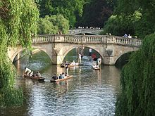
- Bridge of Sighs: crosses the River Cam
- Mathematical Bridge (Mathematical Bridge)
Personalities
sons and daughters of the town
- Douglas Adams (1952-2001), writer
- Richard Attenborough (1923–2014), actor and director
- Ben Barker (* 1991), racing car driver
- Syd Barrett (1946-2006), guitarist, singer and songwriter for Pink Floyd
- Matthew Bellamy (* 1978), front man of the British indie rock band Muse
- Tom Blomqvist (* 1993), Swedish-British racing driver
- Seb Castang (born 1980), actor
- Christopher Cockerell (1910–1999), engineer and inventor
- Simon Donaldson (* 1957), mathematician
- Jane Fawcett (1921–2016), code breaker, opera singer and preservationist
- Alistair Foot (1930–1971), film and playwright
- Phyllis Gardner (1890–1939), artist and illustrator
- Richard Garriott (* 1961), computer game developer
- David Gilmour (born 1946), guitarist, singer and songwriter for Pink Floyd
- Adam Glasser (* 1955), South African musician
- Sarah Haffner (1940–2018), German-British painter and author
- Douglas Rayner Hartree (1897–1958), mathematician and physicist
- Robert Huff (* 1979), racing car driver
- Sergei Kapiza (1928–2012), Soviet-Russian physicist and television presenter
- Geoffrey Keynes (1887–1982), physician, scientist and bibliophile
- John Maynard Keynes (1883–1946), mathematician and economist
- Felix Krämer (* 1971), German-British art historian and curator
- Dominic Lash (* 1980), jazz bassist
- Stephen Law (* 1960), philosopher
- Simon MacCorkindale (1952–2010), film actor and filmmaker
- Rebecca Mader (born 1977), actress
- Bernard Naylor (1907–1986), composer, organist and conductor
- Olivia Newton-John (* 1948), British-Australian singer, actress and songwriter
- Jeremy Northam (born 1961), film and stage actor
- Patrick James O'Flynn (born 1965), politician
- Robin Perutz (* 1949), chemist
- Martin Robertson (1911-2004), classical archaeologist
- Jenny Saville (* 1970), artist
- Ronald Searle (1920–2011), draftsman and caricaturist
- William Thomas Stearn (1911-2001), botanist
- Nick Stone (born 1966), writer
- Harold Neville Vazeille Temperley (1915–2017), theoretical physicist and applied mathematician
- George Paget Thomson (1892–1975), physicist
- THS Walker (1855–1936), cycling pioneer in Germany
- Nick Weldon (* 1954), jazz musician and author
- John Macnaghten Whittaker (1905-1984), mathematician
- Andrew Wiles (* 1953), mathematician
- Amy Williams (* 1982), skeleton pilot
- Barbara Wootton (1897–1988), sociologist, economist and criminologist
Personalities associated with the city
- Shane Acton (1947-2002), circumnavigator
- Jeffrey Archer (* 1940), politician and writer
- Rupert Brooke (1887-1915), poet
- Graham Chapman (1941–1989), actor, writer and screenwriter, member of the Monty Python comedian troupe
- John Cleese (* 1939), actor and screenwriter, member of the Monty Python comedian troupe
- Charles Darwin (1809-1882), naturalist
- Paul Dirac (1902-1984), physicist
- Edward Mountbatten-Windsor, Earl of Wessex (* 1964), son of Queen Elizabeth II and Prince Philip
- EM Forster (1879–1970), writer
- Jack Goody (1919–2015), ethnologist, anthropologist and media theorist
- Stephen Hawking (1942-2018), physicist
- Nick Hornby (born 1957), writer
- Ted Hughes (1930-1998), poet
- Isaac Newton (1643–1727), physicist, mathematician, astronomer, alchemist, philosopher
- Sylvia Plath (1932–1963), poet
- Donald A. Prater (1918–2001), literary scholar and diplomat
- Bertrand Russell (1872–1970), philosopher
- Zadie Smith (* 1975), writer
- Alfred Lord Tennyson (1809-1892), poet
- Emma Thompson (born 1959), actress
- Alan Turing (1912–1954), British mathematician
- Ludwig Wittgenstein (1889–1951), Austro-British philosopher
- Virginia Woolf (1882–1941), writer
- William Wordsworth (1770-1850), poet
Town twinning
Cambridge maintains city partnerships with Heidelberg and Szeged. Both cities are home to a university and have a similar number of inhabitants.
-
 Heidelberg , Germany since 1965
 -
 Szeged , Hungary since 1987
literature
- Franz X. Bogner & Stephen P. Tomkins: The Cam. An Aerial Portrait of the Cambridge River . Laber Foundation, 2015. ISBN 978-0-9932642-0-7 ( http://www.cambridgeriver.info/ )
- Angela Abmeier, Susanne von Poblotzki (illustrator): Cambridge . Goldfinch, Hamburg 2008, ISBN 978-3-940258-05-2 .
- Ursula Heydorn: Cambridge itself . City guide with internet addresses. Books on Demand, Norderstedt 2005, ISBN 978-3-8334-2460-1 .
- Peter Sager : Oxford and Cambridge . A cultural story. Schöffling, Frankfurt am Main 2004, ISBN 978-3-89561-671-6 .
- Peter Sager: Cambridge . A cultural story. Insel , Frankfurt am Main 2008, ISBN 978-3-458-35035-4 (an updated and expanded new edition as Insel-Taschenbuch 3335).
- Frank Henry Stubbings : Bedders, Bulldogs and Bedells. A glossary of Cambridge words and usages . First published by the author 1991; revised and enlarged edition published by Cambridge University Press, Cambridge 1995 ( excerpts online [accessed June 2, 2017]).
Web links
Individual evidence
- ↑ Office for National Statistics : UK Midyear Estimates 2016 , Population Estimates for UK, England and Wales, Scotland and Northern Ireland, June 22, 2017 (XLS file; 1.3 MB).
- ↑ Alexander, J. Pullinger, J. 1999, Excavations on Castle Hill 1956-1988. Proceedings of the Cambridge Antiquarian Society 88, 4-75
- ^ Erich Keyser: Badisches Städtebuch, Verlag Kohlhammer 1959


