Weston, Massachusetts
| Weston | ||
|---|---|---|
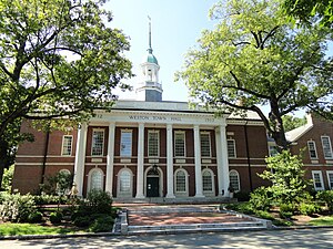
 The Rathaus ( Town Hall ) of Weston |
||
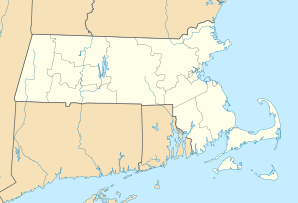
| Location of Weston, Massachusetts | ||
|
|
||
| Basic data | ||
| Foundation : | 1642 | |
| State : | United States | |
| State : | Massachusetts | |
| County : | Middlesex | |
| Coordinates : | 42 ° 22 ′ N , 71 ° 18 ′ W | |
| Time zone : | Eastern ( UTC − 5 / −4 ) | |
|
Inhabitants : - Metropolitan Area : |
11,261 (status: 2010) 4,552,402 (status: 2010) |
|
| Population density : | 255.4 inhabitants per km 2 | |
| Area : | 44.9 km 2 (approx. 17 mi 2 ) of which 44.1 km 2 (approx. 17 mi 2 ) is land |
|
| Height : | 55 m | |
| Postal code : | 02493 | |
| Area code : | +1 781 339 | |
| FIPS : | 25-77255 | |
| GNIS ID : | 0618245 | |
| Website : | www.weston.org | |
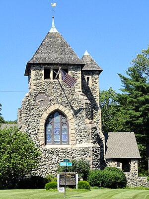
 The First Parish Church in Weston |
||
Weston [ wɜstən ] is a suburb of Boston in Middlesex County in the state of Massachusetts in the United States .
Weston is the richest suburb in the Boston metropolitan area . The city has the highest income per capita in Massachusetts and is one of the 100 most affluent cities with more than 1,000 households in the entire United States. Weston was ranked 97th most expensive postcode region in the United States in 2010 in the prestigious Forbes Magazine . In a comparison with other high schools, Weston High School ranked first in the state of Massachusetts in 2009 after having been voted one of the top 60 public high schools in the USA in 2007 and achieving a gold medal. Compared to other Boston suburbs, the city has a very low crime rate, which is mainly attributed to the fact that Weston was a so-called dry town from 1838 to 2008 . The settlement received city rights in 1713 and is located on a rocky highland plateau .
geography
Expansion of the urban area
According to the United States Census Bureau , the city covers 44.9 square kilometers (17.3 square miles). Of that, 44.1 square kilometers (17.0 square miles) is land, the remainder being water.
Neighboring communities
To the north is Lincoln , in the east Waltham and Newton , in the South Wellesley , Natick is located in the southwest and Wayland in the West. Weston is 12 miles west of Boston , 27 miles south of Lowell , 29 miles east of Worcester and 207 miles away from New York City .
history
The city of Weston was originally established as the western borough of Watertown in 1698 and was granted town charter as the Town of Weston in 1713 .
Weston is located on a rocky plateau, and the early settlers found that the area of usable arable land was very limited, as was the hydropower available. Colonists who came from Watertown in the mid-17th century set up some scattered farms in Weston, and by 1679 a sawmill, several taverns, some doctors and "probably some lawyers" had settled.
In the 18th century, residents benefited significantly from the Boston Post Road , on which the stagecoaches ran between New York City and Boston and which also ran through Weston. On this street, inns were built that were extremely important in their time and some of them still exist today. These include the Josiah Smith Tavern from 1757 and the Golden Ball Tavern from 1768. Commercial traffic on Boston Post Road came to a virtual standstill in 1810 when the Worcester Turnpike opened, which is now State Route Massachusetts Route 9 is being used. This was accompanied by economic stagnation, and from then on the residents of Weston produced shoes or equipment and machine parts for the wool and cotton industry. Around 1870, Boston residents built large country mansions in Weston , giving the city a wealthy character. The local economy was significantly supported by the surrounding farms and in 1888 an organ pipe factory opened in which some residents found work. In 1903 the Weston Reservoir was built, followed in 1938 by the Hultman Aqueduct to transport water to Boston. In exchange for the supply of the water, the Bostonians continued to build houses in Weston. Many had the buildings designed by well-known architects, so that a very high-quality structure continued to emerge.
Famous architects such as Charles Follen McKim and Henry Hobson Richardson designed luxury villas, which further increased the attraction. The place grew in this way rapidly between 1920 and 1935 and then again after the Second World War. To this day, suburbanization has played a major role in Weston's development, and residents pride themselves on the school system and their homes in quiet, well-kept neighborhoods. Weston has retained a large proportion of open space and maintains more than 60 miles of hiking and riding trails, playgrounds, ball courts, golf courses and cross-country ski areas.
The organ pipe factory was completely destroyed by fire in the early 19th century. It is said that when the fire broke out, the local fire brigade was quickly on site and began to extinguish it. However, the water supply was on the other side of the railroad tracks, and the next passing train cut all the hoses the fire department was using to fight the fire. The firefighters now had to fetch the water by hand using a chain of buckets, but this took too long so that the fire could completely destroy the wooden factory.
Population development
| Population development | |||
|---|---|---|---|
| Census | Residents | ± in% | |
| 1990 | 10,200 | - | |
| 2000 | 11,469 | 12.4% | |
| 2010 | 11,261 | -1.8% | |
| 2011 estimate | 11,478 | 1.9% | |
| Age distribution in Weston in 2000 | ||||
|---|---|---|---|---|
| under 18 years | 28.0% | |||
| 18 to 24 years | 7.3% | |||
| 25 to 44 years | 20.4% | |||
| 45 to 64 years | 27.8% | |||
| over 65 years | 16.0% | |||
Based on the 2000 census , Weston had 11,469 residents in 3,718 households and 2,992 families. The population density was 260 inhabitants per square kilometer and there were 3,825 residential units with an average building density of 86.8 units per square kilometer. The distribution of residents by race was 90.26% White , 1.18% African American , 0.05% Indigenous American , 6.82% Asian , 0.05% Pacific Islander , 0.43% other races, and 1, 21% two or more races . Latinos made up 1.90% of the population.
42.3% of 3,718 households had children under the age of 18 living with them. There were married couples in 73.1% of households, 5.6% employed a housekeeper and 19.5% were not families in the strict sense of the word. There were singles in 17.2% of all households and there was a single person in 10.5% who was 65 years of age or older. The average household size was 2.85 people and the average family size 3.21 people.
The population was divided into 28.0% under 18 years, 7.3% between 18 and 24, 20.4% between 25 and 44, 27.8% between 45 and 64 and 16% over 65 years. The median age distribution was 42 years. For every 100 women there were 86.6 men.
The median household income in Weston was 153,918 US dollars per year, the median family income was over 200,000 dollars. In 2007, those numbers rose to $ 189,041 for households and $ 270,000 for families, respectively. Men had a median income of $ 100,000 versus $ 58,534 for women. The per capita income was $ 79,640 per year. Despite this wealth, 2.1% of families and 2.9% of the total population in Weston lived below the poverty line, of which 1.8% were under 18 and 3.9% over 65.
politics
In the 2008 presidential election , Weston supported Democrat Barack Obama with 60% and Republican John McCain with 38% .
Weston has historically been closer to the Republican Party, but has come closer to the Democrats at the state level in recent years. Weston voted in the 1980 and 1984 presidential elections with a majority for Ronald Reagan and in 1988 for George W. Bush , the votes since 1992 with the election of Bill Clinton in 1996, 2000, 2004 and 2008 went to the respective Democratic candidate.
The city lies entirely in the 7th congressional electoral district of Massachusetts and is currently represented in the US House of Representatives by Democrat Ed Markey .
In the extraordinary election for the US Senate in Massachusetts in 2010, Weston voted with 53% for the eventual Republican winner Scott Brown and with 46% for the Democrat Martha Coakley . Scott Brown is currently a Junior Senator, replacing the late Edward Kennedy .
Municipal council
The city is not governed by a mayor, but by the Board of Selectmen , the Town Manager and the Open Town Meeting . A constantly updated list of all official posts and persons can be found on the city's website.
Culture and sights
theatre
- The Weston Friendly Society of the Performing Arts is the second oldest amateur drama group in Massachusetts.
Museums
- The Spellman Museum of Stamps & Postal History is located in the Regis College private school buildings .
Parks
The Case Estates
The Case Estates is a botanical garden in the Wellesley Street Nr. 135. The occupied area is 260,000 square meters. The garden used to be the tree nursery of the Arnold Arboretum .
The estates were founded in 1863 by James Case , who bought the core property that year. In 1909, his daughter Marian Roby Case bought adjoining properties, then opened Hillcrest Farms and operated it from 1909 to 1942 as an experimental fruit and vegetable grower. In 1942 she left the property to Harvard University , which then sold most of the farm buildings. The former Case family estate is now used for school administration in Weston.
Today the property is partially privatized and offers lovingly designed gardens and rare plants. Most of the property consists of an evergreen forest in an almost natural state and can be explored via various hiking trails. There is also a rhododendron display garden, which is maintained by the local department of the American Rhododendron Society .
A very interesting detail of the estates is an eye-catching stone wall that was erected in 1911 as a birthday present from Ms. Case to her sister Louisa. The wall is about three meters high, up to 1.80 m thick and 61 m long. It is described as "the largest or longest free-standing dry wall in New England ".
In 2006 Harvard University decided to sell the estates. On November 8, 2006, a specially convened city council in Weston decided to buy the site for $ 22.5 million. However, the city council intends to resell up to 10 parcels of the property in order to obtain at least partial refinancing.
Sports
The Leo J. Martin Golf Course has been offering a par-72 course with a total of 6,320 yd (5,779 m) over 18 holes since it opened in 1930 . In the winter months, the course is converted into a cross-country ski facility.
Economy and Infrastructure
traffic
Weston has three MBTA stops ( Silver Hill , Kendal Green and Hastings ), all of which are served by the Boston-Fitchburg rail line. All of the stops are relatively small and have limited service.
education
There are a number of good schools in Weston. Particularly noteworthy are the Weston High School , the Cambridge School of Weston , the Rivers School and the Tremont School.
Personalities
Well-known athletes
- David Ortiz , Boston Red Sox DH / 1B
- ML Carr , former player and coach for the Boston Celtics
- John Havlicek , former Boston Celtics player
- Cedric Maxwell , former Boston Celtics player and current radio host
- Bobby Orr , Boston Bruins player
- Jerry Remy , former Boston Red Sox player and current TV host
- Kevin Youkilis , Boston Red Sox player
sons and daughters of the town
- William A. Knowlton , American 4-Star General
Personalities who have worked on site
- Steve Belkin , owner of the Atlanta Hawks and Thrashers
- Frederic C. Dumaine, Jr. , American businessman and leader of the Republican Party in Massachusetts from 1963 to 1965
- Sarah Fuller , writer and teacher who taught Helen Keller
- Jeremy Jacobs , owner of the Boston Bruins
- Steve Pagliuca , Managing Director of Bain Capital and co-owner of the Boston Celtics
- Ellen Richstone , former CEO of Sonus Networks and currently a manager at Luminus
- Joe Shortsleeve , WBZ-TV's chief correspondent
Individual evidence
- ↑ Boston.com: Weston has 97th most expensive zip code on Forbes list. October 26, 2010, accessed September 9, 2011 .
- ^ Boston Magazine: Public Schools Chart. (No longer available online.) 2009, archived from the original on July 8, 2010 ; accessed on September 9, 2011 . Info: The archive link was inserted automatically and has not yet been checked. Please check the original and archive link according to the instructions and then remove this notice.
- ↑ US News & World Report: Best High Schools. Retrieved September 9, 2011 .
- ^ Casey Ramsdell: Popping the cork in Weston. In: The Boston Globe. September 10, 2008, accessed September 9, 2011 .
- ↑ Town of Weston: About Weston. (No longer available online.) Archived from the original on September 6, 2011 ; accessed on September 9, 2011 . Info: The archive link was inserted automatically and has not yet been checked. Please check the original and archive link according to the instructions and then remove this notice.
- ^ Weston Historical Society: Boston Post Road. (No longer available online.) Formerly in the original ; accessed on September 11, 2011 . ( Page no longer available , search in web archives ) Info: The link was automatically marked as defective. Please check the link according to the instructions and then remove this notice.
- ^ Weston Historical Society: Josiah Smith Tavern. (No longer available online.) 2011, archived from the original on March 21, 2012 ; accessed on September 11, 2011 . Info: The archive link was inserted automatically and has not yet been checked. Please check the original and archive link according to the instructions and then remove this notice.
- ↑ Golden Ball Tavern Museum. Retrieved September 11, 2011 .
- ^ Weston Historical Society: Hook & Hastings Organ Factory. (No longer available online.) Archived from the original on September 2, 2011 ; accessed on September 11, 2011 . Info: The archive link was inserted automatically and has not yet been checked. Please check the original and archive link according to the instructions and then remove this notice.
- ^ Weston Historical Commission. Retrieved September 11, 2011 .
- ↑ United States Census Bureau : American FactFinder. Retrieved September 9, 2011 .
- ^ Boston.com: 2008 presidential election results by town for Massachusetts. November 4, 2008, accessed September 9, 2011 .
- ^ Boston.com: Town-by-town results. January 19, 2010, accessed September 9, 2011 .
- ^ List of Weston Elected Officials. (No longer available online.) Archived from the original on November 15, 2011 ; accessed on September 12, 2011 . Info: The archive link was inserted automatically and has not yet been checked. Please check the original and archive link according to the instructions and then remove this notice.
- ^ Spellman Museum of Stamps & Postal History. Retrieved September 13, 2011 .
- ^ Stephanie V. Siek: With one voice, farm land saved. Estate's 62 acres cost town $ 22.5m. In: Boston.com. November 12, 2006, accessed September 9, 2011 .
- ^ Leo J. Martin Golf Course
- ^ Massachusetts Bay Transport Authority: MBTA Commuter Rail. Fitchburg / South Acton Lines Schedules and Maps. Retrieved September 9, 2011 .
- ^ Weston High School. (No longer available online.) Archived from the original on July 28, 2011 ; accessed on September 11, 2011 . Info: The archive link was inserted automatically and has not yet been checked. Please check the original and archive link according to the instructions and then remove this notice.
- ^ Cambridge School of Weston. Retrieved September 11, 2011 .
- ^ Rivers School. Retrieved September 11, 2011 .
- ^ Tremont School. independent day school. Retrieved September 11, 2011 .
Web links
- Town of Weston. Retrieved on September 9, 2011 (English, website of the city administration).
- Diana Chaplin, Great Estate: Slide Show of Weston. Retrieved September 9, 2011 .
- Weston Library. Retrieved September 9, 2011 (Weston Public Library website).
- Diana Chaplin, Great Estate: Random Recollections. by Brenton H. Dickson. Retrieved September 9, 2011 (A Book About Growing Up in Weston).

