Needles
| Needles | ||
|---|---|---|
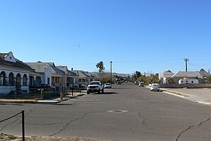
 Residential area in Needles |
||
| Location in California | ||
|
|
||
| Basic data | ||
| Foundation : | October 30, 1913 | |
| State : | United States | |
| State : | California | |
| County : | San Bernardino County | |
| Coordinates : | 34 ° 50 ′ N , 114 ° 37 ′ W | |
| Time zone : | Pacific ( UTC − 8 / −7 ) | |
| Residents : | 4,844 (as of 2010) | |
| Population density : | 62.8 inhabitants per km 2 | |
| Area : | 78.2 km 2 (approx. 30 mi 2 ) of which 77.1 km 2 (approx. 30 mi 2 ) are land |
|
| Height : | 151 m | |
| Postal code : | 92363 | |
| Area code : | +1 760 | |
| FIPS : | 06-50734 | |
| GNIS ID : | 1652757 | |
| Website : | www.cityofneedles.com | |
| Mayor : | Edward Paget | |
Needles is a place in the US state of California . The urban area covers an area of 78.1 square kilometers. The place is located at the eastern end of San Bernardino County not far from the border with the state of Arizona .
history
The city was founded in 1883 when a railroad line was built to cross the Colorado River at this point . The Route 66 also leads through the city. The city is known for its extreme heat in summer, with temperatures regularly reaching 49 degrees Celsius in summer. On July 17, 2005, 51.6 degrees Celsius were measured.
Demographics
At the 2010 census , Needles had 4,844 residents, spread across 1940 households and 1,268 families. The population density was thus 62.6 inhabitants per square kilometer. 77.87 percent of the population were white, seven percent Native American. Children under the age of 18 lived in 31.2 percent of households. The median income per household was $ 26,108 annually, with 26.1 percent of the population living below the poverty line .
Web links
Individual evidence
- ↑ Website of the US Census Bureau (English)


