Fontana (California)
| Fontana | |
|---|---|
 |
|
 seal |
 flag |
| Location in California | |
| Basic data | |
| Foundation : | November 30, 1977 |
| State : | United States |
| State : | California |
| County : | San Bernardino County |
| Coordinates : | 34 ° 6 ′ N , 117 ° 26 ′ W |
| Time zone : | Pacific ( UTC − 8 / −7 ) |
| Residents : | 196,069 (as of 2010) |
| Population density : | 1,784.1 inhabitants per km 2 |
| Area : | 109.899 km 2 (approx. 42 mi 2 ) of which 109.899 km 2 (approx. 42 mi 2 ) is land |
| Height : | 377 m |
| Postcodes : | 92331, 92334-92337 |
| Area code : | +1 909 |
| FIPS : | 06-24680 |
| GNIS ID : | 1652711 |
| Website : | www.fontana.org |
| Mayor : | Acquanetta Warren |
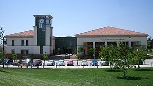
 Lewis Library |
|
Fontana is a city in San Bernardino County in the US state California , with around 196,000 inhabitants (as of 2010). The urban area extends over an area of around 110 km².
geography
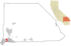
The city is located in the southwest of San Bernardino County in California . It is bordered to the southwest by Ontario , to the northwest by Rancho Cucamonga , to the east by Rialto and to the southeast by Bloomington (California) . In the south, Fontana borders on Riverside County with the town of Jurupa Valley . To the north are the San Gabriel Mountains . To the west of Fontana is the Auto Club Speedway .
Fontana has 196,069 inhabitants (as of the 2010 census). The city extends over an area of approximately 109.9 km², which consists entirely of land; the population density is 1784.1 inhabitants per km². The city center is located at an altitude of 377 meters. Fontana is part of the Inland Empire metropolitan region .
Several major trunk roads run through Fontana. Interstate 10 runs through the southern metropolitan area , while Interstate 15 touches the northern edge of the city. Furthermore, California State Routes 66 and 210 run parallel to each other through Fontana.
climate
The climatic conditions in Fontana are typical for the region in southern California. In summer there is a dry climate with little rainfall, with daytime temperatures usually well above 30 degrees Celsius . Record values of over 42 degrees were already measured in the months of May to September. Precipitation is mostly concentrated in the winter months, in which the thermometer, however, usually remains clearly in the plus range.
history
In the late 19th century, the area east of Los Angeles was a sparsely populated agricultural region. The Santa Fe Railroad , which built a railway line between Los Angeles and San Bernardino , built a railway city called Rosena in what is now Fontana’s urban area . From 1903 Azariel Blanchard Miller acquired land and developed a new agricultural center. In 1913 the newly created village was finally given the name Fontana. Until the Second World War , Fontana remained a small town on Route 66, dominated by citrus and poultry farms .
The US entry into the war changed this forever. The shipyards on the west coast needed steel, and so Henry John Kaiser built a steel mill near Fontana which went into operation in 1943. Fontana was chosen as the location because the city had good transport connections and was far enough away from the Pacific coast threatened by the Japanese . Kaiser Steel was one of only two American steelworks west of the Mississippi River and was expanded further in the years after the war.
On June 25, 1952 Fontana was declared an independent municipality, the city had around 15,000 inhabitants at that time. The steelworks, which provided work for thousands of people, ran into economic difficulties from the 1960s, and its location remote from the coast proved to be disadvantageous after the war. In the 1980s Kaiser Steel went bankrupt and a large part of the facilities was dismantled. California Steel Industries now owns a small part of the former factory site and employs around 1,000 people. The Auto Club Speedway , which opened in 1997, was built on a larger part of the former industrial wasteland.
Fontana's population has grown rapidly in the last two decades, from 87,000 in 1990 to just under 200,000. In addition to numerous new housing estates, the incorporation of neighboring unincorporated areas was also responsible for this.
Demographics
The 2010 census showed a population of 196,069, an increase of around 70,000 within ten years. According to the census, a little less than half were white people in the approximately 49,000 households in the city. Around 60 percent belong to the Latino ethnic group . Other population groups such as African-Americans , Americans of Asian descent or others represent minorities. According to the census, there were also 98.7 men for every 100 women, while the median age was 28.7 years.
politics
Fontana is part of the 20th district in the California Senate represented by Democrat Alex Padilla . In the California State Assembly , the place is assigned to the 47th District, represented by the Democrat Cheryl Brown . At the federal level, Fontana is a member of California's 35th Congressional District , which has a Cook Partisan Voting Index of D + 15.
Miscellaneous
- The Auto Club Speedway oval race track is well known , on which ChampCars achieved speeds of up to 388 km / h and NASCAR races also take place. In 1999, ChampCar driver Greg Moore had a fatal accident here .
- The Hells Angels Motorcycle Club was founded in 1948 in the Fontana / San Bernardino region.
Personalities
sons and daughters of the town
- Mike Davis (* 1946), social commentator, sociologist and historian
- Bill Fagerbakke (* 1957), actor and voice actor
- Stephanie Rehe (* 1969), tennis player
- Travis Barker (* 1975), drummer for the American pop-punk band blink-182
- Torri Edwards (born 1977), track and field athlete
- Lucas Duda (born 1986), baseball player
- Maurice Edu (* 1986), football player
- Leo Romero (* 1986), professional skateboarder (Thrashers Skater of the Year 2010)
- Jalil Anibaba (* 1988), football player
Personalities associated with Fontana
- Sammy Hagar (* 1947), rock musician from Van Halen , attended high school in Fontana
- Marvin Jones (born 1990), American football player
Web links
- Website of Fontana (English)
- Further information and pictures on city-data.com (English)
Individual evidence
- ↑ Introduction of the mayor. Fontana official website.
- ↑ Climatic information (English)
- ↑ Britannica.Com: Fontana (California)
- ↑ Kaiser Steel ( Memento of the original from October 29, 2013 in the Internet Archive ) Info: The archive link was inserted automatically and has not yet been checked. Please check the original and archive link according to the instructions and then remove this notice.
- ↑ United States Census 2010 ( Memento from February 20, 2011 in the Internet Archive )
- ↑ Card of the 20th Senate district. Around the Capitol.
- ^ List of Senators in California. Official website of the Senate of California.
- ^ Map of the 47th Assembly District. Around the Capitol.
- ^ List of members of the California State Assembly. Official website of the California State Assembly.
- ^ Map of the 35th congressional electoral district. Around the Capitol.
- ^ Table with Cook Partisan Voting Index of all congressional districts. (PDF; 115 kB) Official website of the Cook Political Report .
- ↑ www.hells-angels.com


