Chino (California)
| Chinos | |
|---|---|
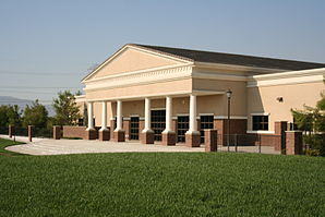
 Cal-Aero Academy at Chino Airport |
|
 seal |
 flag |
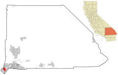
| Location in California | |
| Basic data | |
| Foundation : | 1910 |
| State : | United States |
| State : | California |
| County : | San Bernardino County |
| Coordinates : | 34 ° 1 ′ N , 117 ° 41 ′ W |
| Time zone : | Pacific ( UTC − 8 / −7 ) |
| Residents : | 77,983 (as of 2010) |
| Population density : | 1,015.9 inhabitants per km 2 |
| Area : | 76,799 km 2 (approx. 30 mi 2 ) of which 76,766 km 2 (approx. 30 mi 2 ) is land |
| Height : | 222 m |
| Postcodes : | 91708, 91710 |
| Area code : | +1 909 |
| FIPS : | 06-13210 |
| GNIS ID : | 1660477 |
| Website : | www.cityofchino.org |
| Mayor : | Dennis R. Yates |
Chino is a city in the US state of California with around 78,000 inhabitants (as of 2010). It is located in the southwestern part of San Bernardino County . The urban area has a size of 76.8 square kilometers and has no industry to speak of .
The shooting sports competitions of the 1984 Olympic Games were held in the Prado Regional Park in Chino .
The city is also known for its local prisons: the all-male California Institution for Men is the oldest major US prison, built in 1941 with only minimal security features; it has about 5800 inmates. The all-women's prison California Institution for Women houses approximately 2,500 inmates under minimal to medium security.
In 2012, Chino was named one of the Top 100 Churches for Young People by America's Promise Alliance for the fifth time .
geography
The city is located in the southwest of San Bernardino County in California . It is bordered to the west by Chino Hills , to the north by unincorporated territory, to the northeast by Ontario and to the southeast by Eastvale in Riverside County .
The southeastern city limit roughly follows California State Route 71 . Other major roads in Chino are California State Routes 60 and 83 .
Chino has 77,983 inhabitants (as of the 2010 census). The city extends over an area of approximately 76.8 km², of which the land area makes up the largest part; the population density is thus 1015.9 inhabitants per square kilometer. The city center is located at an altitude of 222 meters.
history
The first inhabitants of today's city of Chino were Indians from the Tongva tribe , who lived in the settlement of Wapijangna in the catchment area of the Santa Ana River . After the San Gabriel Arcángel Mission was founded in 1771, some of the indigenous people were baptized. The land fell to the Spanish crown and later to the independent state of Mexico .
About twenty years later, the then Governor of Upper California , Juan Bautista Alvarado , awarded the territory of Rancho Santa Ana del Chino Antonio Maria Lugo. Two years later, the incumbent governor Manuel Micheltorena handed over three more League land to Antonio Maria Lugo's son-in-law Isaac Williams, who had meanwhile taken over the rancho. Williams owned many cattle and horses, which led to raids by Indians and whites. One of them was James P. Beckwourth , who posed as an otter hunter in 1840 in order to be able to observe the animals in the vicinity of Rancho Chino. He then shared his information with Chief Walkara, who coordinated the raids by the Ute Indians .
In the early Mexican-American War , a battle took place at Williams' rancho in which 24 soldiers from the Republic of California were defeated by 50 Mexicans.
During the California gold rush , the rancho was used as a stopover for travelers and coal was discovered on the premises. After California became American in 1850, Isaac Williams was officially granted his lands in 1869.
The next owner of the rancho was Richard Gird. From 1887 his land was redistributed so that the city of Chino was created. In 1910 it was promoted to City .
The Chino Valley, located at the foot of an alluvial plain, was dominated by agriculture from the 1890s to the mid-20th century, which can be attributed in particular to the fertile soils down to a meter depth. At the beginning of the 20th century who made sugar beet a significant part of the economy, followed by sweet corn , which on the Pacific coast as Chino corn was marketed, as well as peaches , walnuts , tomatoes and strawberries .
From the 1950s to the 1980s, milk production gained in importance, which was also favored by special dairy areas that were created in southwestern San Bernardino County . Families of Dutch ethnicity in particular formed the foundation for the emerging industry that soon afterwards made Chino the largest milk-producing town in the United States.
Due to its rural location and atmosphere, Chino was a popular location for film scenes that were to take place in the Midwest .
Many historically significant elements of the city were hastily demolished in times of real estate speculation. In addition to a large building that had to make way for the now closed “Value Fair” shopping center, areas in the old town were also expanded to include new courts, police stations and the town hall. The lower-lying parts of the city were often flooded in the past, and even today the areas around the Prado Dam are threatened by flooding during heavy rainfall.
In the late 1970s, Chino developed into a small suburb on the western edge of the Inland Empire metropolitan area . Meanwhile, the character of the city is more dominated by the middle class, although industrial areas and pastureland still exist.
Demographics
The 2010 census found a population of 77,983. Thus, an increase of over 12,000 people could be determined within ten years. In 2000 there were still 67,300 people living in Chino. The proportion of Latinos in the total population rose by around six percent. In 2010 their share was 53 percent, which means that the city has a higher percentage of this population group than the state of California. Whites of European descent made up around 40 percent of the city's population, while Afro-Americans as a minority made up only six percent of the city's population. According to the census, there were 105.7 men for every 100 women. The city's population was distributed among 21,797 households, while the median age was 33.2 years.
politics
Chino is part of the 20th district in the California Senate , currently represented by Democrat Alex Padilla . In the California State Assembly , the place is assigned to the 52nd District and is thus represented by the Democrat Freddie Rodriguez . At the federal level, Chino is a member of California's 35th Congressional constituency , which has a Cook Partisan Voting Index of D + 15 and is represented by Democrat Gloria Negrete McLeod .
economy
Chino and the surrounding areas have long been the center of agricultural and dairy businesses. The city had to meet the high demand for milk in southern California and much of the southwestern United States. The history of agriculture in Chino can be traced back to Rancho Santa Ana del Chino during the Spanish rule over California. In addition to the dairy industry, orchards and the cultivation of root crops emerged as the main components of local agriculture .
Downtown is home to branches of the San Bernardino County Library and Chaffey Community College, as well as the Chino Community Theater and Chino Boxing Club. There is a weekly farmers market.
sons and daughters of the town
- Harold E. Stine (1903-1977), cameraman
- Robert Burks (1909–1968), cameraman
- Paula Pierce (1960–1991), singer, guitarist, composer and leader of the rock band The Pandoras
- Alisha Klass (* 1972), porn actress
- Shelly Martínez (* 1980), model, actress, wrestler and valet
- Diana Taurasi (* 1982), basketball player
Web links
- Internet presence of quinone (English)
- Further information at City-Data.com (English)
Individual evidence
- ^ Presentation of the members of the city council on the city website. ( Memento of the original from February 26, 2014 in the Internet Archive ) Info: The archive link was inserted automatically and has not yet been checked. Please check the original and archive link according to the instructions and then remove this notice.
- ↑ Press release on the Chino website ( Memento of the original from February 26, 2014 in the Internet Archive ) Info: The archive link was inserted automatically and has not yet been checked. Please check the original and archive link according to the instructions and then remove this notice. September 12, 2012.
- ↑ Chino Police History ( Memento of the original from August 26, 2009 in the Internet Archive ) Info: The archive link was inserted automatically and has not yet been checked. Please check the original and archive link according to the instructions and then remove this notice. Chino Police Department website
- ↑ United States Census 2010 ( Memento from February 20, 2011 in the Internet Archive )
- ↑ Card of the 20th Senate district. Around the Capitol.
- ^ List of Senators in California. Official website of the Senate of California.
- ^ Map of the 52nd Assembly District. Around the Capitol.
- ^ List of members of the California State Assembly. Official website of the California State Assembly.
- ^ Map of the 35th congressional electoral district. Around the Capitol.
- ^ Table with Cook Partisan Voting Index of all congressional districts. (PDF; 115 kB) Official website of the Cook Political Report .
- ↑ List of California MPs in the House of Representatives. Official website of the United States House of Representatives.


