Montclair (California)
| Montclair | |
|---|---|
 Montclair Transcenter |
|
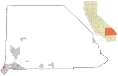
| Location in California | |
| Basic data | |
| Foundation : | 1956 |
| State : | United States |
| State : | California |
| County : | San Bernardino County |
| Coordinates : | 34 ° 5 ′ N , 117 ° 41 ′ W |
| Time zone : | Pacific ( UTC − 8 / −7 ) |
| Residents : | 36,664 (as of 2010) |
| Population density : | 2,565.9 inhabitants per km 2 |
| Area : | 14.289 km 2 (approx. 6 mi 2 ) of which 14.289 km 2 (approx. 6 mi 2 ) is land |
| Height : | 325 m |
| Postal code : | 91763 |
| Area code : | +1 909 |
| FIPS : | 06-48788 |
| GNIS ID : | 252320 |
| Website : | www.cityofmontclair.org |
| Mayor : | Paul M. Eaton |
Montclair is a city in the US state of California . It is located in the southwest of San Bernardino County and has around 36,700 inhabitants. The urban area covers an area of 14.3 square kilometers.
geography
The city is located in the southwest of San Bernardino County in California . It is bordered to the south by Chino , to the east by Ontario , to the north by Upland and to the west by the two cities of Claremont and Pomona in Los Angeles County .
Interstate 10 , a major highway connecting California with Florida , runs through Montclair .
Montclair has 36,664 inhabitants (as of the 2010 census). The city extends over an area of approximately 14.3 km², which consists entirely of land; the population density is thus 2565.9 inhabitants per square kilometer. The city center is located at an altitude of 325 meters.
The region's climate is shaped by its geographical location on the edge of the Mojave Desert . The summers are dry and hot, while the winter months are mild and rainy.
history
The first known inhabitants of the region were Indians from the Serrano tribe . They founded a village on Arroyo de los Alisos, now known as San Antonio Creek. The course of the creek roughly followed that of today's Mills Avenue, which marks the western boundary of Montclair.
In 1897, the Township of Marquette was founded in the area of what is now Montclair . Three years later, an area of four square kilometers was measured that became a settlement called Monte Vista . In 1907, Narod was again a smaller settlement in the south of Monte Vista. In the first half of the 20th century, the area was mainly characterized by the cultivation of citrus fruits in orchards. After the Second World War, Monte Vista grew in population, and on April 25, 1956, the city was registered as a city . However, since a parish already had the same name in Northern California, no post office could be established in the new town. For this reason, Monte Vista was officially renamed Montclair on April 8, 1958 .
politics
Montclair is part of the 20th district in the California Senate , currently represented by Democrat Alex Padilla . In the California State Assembly , the place is assigned to the 52nd District and is thus represented by the Democrat Freddie Rodriguez . At the federal level, Montclair is a member of California's 35th Congressional constituency , which has a Cook Partisan Voting Index of D + 15 and is represented by Democrat Gloria Negrete McLeod .
Demographics
According to the 2010 census , the number of residents was 36,664, the majority of the population consisted of Latinos , who are generally well represented in southern California. Compared to the year 2000, the city population has increased by around 3,000, when it was just over 33,000. The 2010 census also showed that at the time of its survey there were 9,523 households in Montclair.
sons and daughters of the town
- Danny Califf (born 1980), football player
- Nick Rimando (* 1979), soccer player
Web links
- Internet presence of Montclair (English)
- further information and pictures on CityData.com (English)
Individual evidence
- ^ City Elected Officials. ( Memento of the original from October 15, 2014 in the Internet Archive ) Info: The archive link was inserted automatically and has not yet been checked. Please check the original and archive link according to the instructions and then remove this notice. Official website of Montclair.
- ↑ Card of the 20th Senate district. Around the Capitol.
- ^ List of Senators in California. Official website of the Senate of California.
- ^ Map of the 52nd Assembly District. Around the Capitol.
- ^ List of members of the California State Assembly. Official website of the California State Assembly.
- ^ Map of the 35th congressional electoral district. Around the Capitol.
- ^ Table with Cook Partisan Voting Index of all congressional districts. (PDF; 115 kB) Official website of the Cook Political Report .
- ↑ List of California MPs in the House of Representatives. Official website of the United States House of Representatives.
- ↑ United States Census 2010 ( Memento from February 20, 2011 in the Internet Archive )


