Lake McConaughy
| Lake McConaughy | |||||||||
|---|---|---|---|---|---|---|---|---|---|
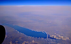
| Aerial view of Lake McConaughy | |||||||||
|
|||||||||
|
|
|||||||||
| Coordinates | 41 ° 13 ′ 30 ″ N , 101 ° 43 ′ 0 ″ W | ||||||||
| Data on the structure | |||||||||
| Construction time: | 1941 | ||||||||
| Height of the barrier structure : | 49 m | ||||||||
| Crown length: | 5 000 m | ||||||||
| Base width: | 335 m | ||||||||
| Data on the reservoir | |||||||||
| Altitude (at congestion destination ) | 998 m | ||||||||
| Water surface | 144 km² | ||||||||
| Reservoir length | 35 km | ||||||||
| Reservoir width | 6.4 km | ||||||||
| Maximum depth | 43 m | ||||||||
| Lake surface with surroundings | |||||||||
| Discharge tower | |||||||||
The Lake McConaughy (also known as Kingsley Reservoir ) is a reservoir in Keith County in the US state of Nebraska . It is dammed by a dam on the North Platte River .
location
Lake McConaughy is located a few miles north of Ogallala , the county seat of Keith County . It extends mainly in a west-east direction. The US Highway 26 runs in inigem distance south of the lake, which the State Highway NE 92 carries at its northern shore. There are a few smaller settlements on this road, while the southern shore of the lake is mostly undeveloped. The village of Lewellen is located upstream of the lake . East of the dam is Ogallala Lake, and further downstream is the community-free village of Keystone .
history
In 1941 the Kingsley Dam was built to damm the lake. Charles W. McConaughy, after whom the lake is named, was a grain merchant and mayor of Holdrege, Nebraska, and a leading sponsor of the project. The dam was named after George P. Kingsley, a banker from Minden, Nebraska, who drove the project with Charles W. McConaughy. The reservoir was created for irrigation purposes . In 1984 a hydropower plant was put into operation at the southern end of the dam .
description
The lake is 35 km long and 6.4 km wide at its widest point. It has a water surface of 144 km² and is 43 m deep at its deepest point.
The operation of the dams and the power station is carried out by the Central Nebraska Public Power and Irrigation District , a subunit of the state of Nebraska, which was established in 1933.
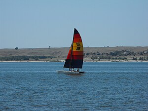
The lake and its banks are a recreation area called the Lake McConaughy State Recreation Area . Fishing, boating and water sports are practiced on the lake, the shore is available for camping.
Web links
Individual evidence
- ↑ Lake McConaughy. In: Geographic Names Information System. Retrieved December 26, 2017 (American English).
- ^ The Central Nebraska Public Power and Irrigation District. Retrieved December 26, 2017 (American English).


