US Highway 395
| map | |
|---|---|

|
|
| Basic data | |
| Overall length: | 1305 mi / 2100 km |
| Opening: | 1926 |
| States: |
California Nevada Oregon Washington |
| Starting point: |
|
| End point: |
|
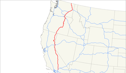
The US Highway 395 is a United States highway in the United States . It begins in the Mojave Desert on Interstate 15 at Hesperia and ends on the Canadian border near Laurier in Washington state , where it becomes British Columbia Highway 395 . His number identifies him as a branch line of US Highway 95 , although he never touches it. Instead, it was derived from its first-order branch line US Highway 195 and only became a real parallel line to US 95 when it was extended to the south.
The highway runs west along the Sierra Nevada in the Owens Valley and crosses the Modoc Plateau .
history
US Highway 395 used to start in downtown San Diego . This section is now between Hesperia and Devore to Interstate 15 as well as between Devore and Temecula to Interstate 215 for . As far as Fallbrook , the former highway follows the I-15 again, after which it follows the CA 76 to Escondido and meets the I-15 again. South of Miramar , it then follows the CA 163 to downtown San Diego.
Web links
- End of US Highways (English)
