Scotts Bluff National Monument
| Scotts Bluff National Monument | ||
|---|---|---|
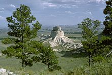
| Saddle Rock, a crag off Scotts Bluff | ||
|
|
||
| Location: | Nebraska , United States | |
| Specialty: | Striking cliff, as an important landmark for pioneers in the "Wild West" | |
| Next city: | Low | |
| Surface: | 12.2 km² | |
| Founding: | December 12, 1919 | |
| Visitors: | 99,600 (2005) | |
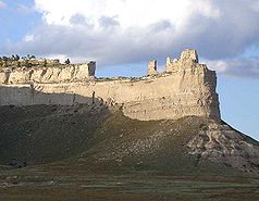
Scotts Bluff National Monument is a protected area by the type of National Monuments in the US -Bundesstaat Nebraska . Core of the area is a cliff of sandstone on the south bank of the North Platte River , which is an important in the mid-19th century milestone of all pioneers and settlers on the way over the Rocky Mountains showed.
The area was placed under protection in 1919, developed in the 1930s and is under the administration of the National Park Service . It is named after a trapper named Hiram Scott who allegedly died near the striking rock formation in 1828. Bluff means a cliff in English .
description
Scotts Bluff National Monument is on the south bank of the North Platte River on the outskirts of the small town of Gering . It consists of a cliff made of sandstone, which is divided into several witness mountains by erosion processes . Badlands , a plateau from which erosion has washed away steep gullies and ditches, join in the northern part . There are several channels on the river bank for the artificial irrigation of agricultural areas outside the protected area. In the southwest of the area, two passes lead over Scotts Bluff, the old Robidoux Pass , a sandy hiking trail, and the Mitchell Pass , which is more suitable for covered wagons , on which a small highway now runs.
geology
Geologically, the rocks of Scotts Bluff were formed between 33 and 20 million years ago. They belong to the Oligocene and the early Miocene . Layers of siltstone , volcanic ash and clay are embedded in the sandstone . Layers of harder limestone also formed in some places . The rock arose from alluvial fans that were formed when material was deposited in a continental basin . The pressure of later layers compacted them into sandstone. Tectonic processes lifted the whole of the Great Plains and tilted them from west to east.
Rivers cut their way through the slope and eroded the soft sandstone. Only where the harder limestone protected the underlying layers did cliffs and witness mountains remain. Today the highest point of Scotts Bluff is 1400 m and thus about 260 m above the North Platte River.
Ecosystems
There is only fertile soil on the river bank, here is a hardwood meadow . About 40% of the area is characterized by a small-scale mosaic of different plant communities of the mixed grass prairie . In the higher areas there are yellow pine and juniper .
So far, 21 fish species, 6 amphibians, 9 reptiles, 101 bird species and 28 mammals have been identified in the protected area. The Badlands is home to a colony of blacktail prairie dogs , one of the largest populations in any protected area in the United States. The rare owl , a small species of owl that breeds in burrows, lives in the prairie dog's burrows.
On the banks of the nests mountain plover , the bald eagle is a winter visitor to the North Platte River, the whooping crane uses the area as a resting place on the train and could in the future also breed on the river. Prairie falcons breed in the steep walls, peregrine falcons have only been seen as guests. Swift foxes roam the entire sanctuary.
Fossils
In the badlands, layers of rock emerge in which fossils are stored. Thanks in particular to the Brule Formation , Scotts Bluff National Monument is one of the most species-rich and individual-rich deposits in Nebraska. Fossil horses , orodontas , prairie dogs , foxes , turtles , rodents , beavers and cats have been found here.
history
In the region around Scotts Bluff, the traditional areas of Cheyenne , Pawnee , Lakota (Sioux) and Arapaho overlap . Other races like the Absarokee , Blackfoot and Kiowa came to the area at least occasionally. The Lakota chief Crazy Horse is said to have experienced one of his first vision quests in the area . He saw horses and heard thunder, after which he prepared himself and his people for war with the whites. The Indian prehistory of the area was first examined in 1966, then again in 1994. 62 archaeological sites are registered within the park, 19 of which cannot be found or have been destroyed, two of which date from historical times, the others come from prehistoric Indian peoples.
It is believed that six Pacific Fur Company trappers were the first white men to pass Scotts Bluff on their way back from Astoria in 1812 , but their route is not recorded. In the spring of 1824, the trapper and fur trader Jedediah Smith , who operates from St. Louis , recognized the first easy-to-pass mountain pass over the Rocky Mountains in the South Pass . In the years that followed, trappers explored the trails into the Rocky Mountains, including the route on the North Platte River. Hiram Scott, one of them, died in 1828 in what is now the protected area, according to contemporary reports. In 1831 Smith's partner William Sublette first brought a covered wagon train from St. Louis over the South Pass into the mountains, establishing a route that all pioneers and settlers would follow for the next few decades.
The path known as the Oregon Trail , California Trail and Mormon Trail led along the Missouri River , left it at Independence , Missouri, led through the prairies of what is now the state of Kansas to the Platte River and followed it upstream. From the mouth of the North Platte River, the route ran along it and after almost 300 km reached the first significant elevation above the river - the Scotts Bluff cliff . Here the travelers had to leave the river for the first time and switch to the Robidoux Pass or the Mitchell Pass, which is a little further south-west, but which is easier for covered wagons to pass .
In 1836 the missionary Marcus Whitman passed Scotts Bluff on the way to Oregon, in 1840 John Bidwell and Thomas Fitzpatrick led the first settlers to California along the North Platte River and from 1842 there were emigration trains to Oregon. Starting in 1847, followers of the Church of Jesus Christ of Latter-day Saints ("Mormons") also used the route to travel to settlement areas where they could pursue their young and controversial religion without fear of persecution. With the California gold rush of 1848/49, the numbers of settlers exploded; in 1849 alone, 25,000 people moved to California.
"8th. June [1849]: We passed Scott's Bluffs - as we approached we began to turn left, leaving the cliffs between us and the river - we began to climb rapidly into the highlands - about halfway up we found an excellent spring with cold water - an old French trader named Troubadore lives at the source [Correct name: Robidoux, a descendant of the fur trade family from St. John / St. Louis] - he has a wife and family - he does business with the fur traders - we continued the climb and reached the top of the pass for a short rest - the view from this point is delightful - the jagged chain of the Black Hills appears around 50 Miles away to the west, stretching left and right as far as the eye can see, while beyond them and looming far above the peaks of the Rocky Mountains are visible. We moved a short distance over the ridge and built our camp. "
In total, about 250,000 people moved along the river over the mountains to Oregon and California. In 1860 the Pony Express also ran along the way . The road route over Scotts Bluff suddenly lost its importance when the transcontinental rail link was opened in 1869 . She crossed the Rocky Mountains further south. Today US Highway 26 still runs across the river.
Scotts Bluff National Monument today
Scotts Bluff was designated a National Monument under US President Woodrow Wilson in 1919 to commemorate the pioneers and settlers on the Oregon Trail . Visitor facilities and the road to the top of the cliff were built in the 1930s as part of the New Deal . At 12 km², the protected area is rather small, but with almost 100,000 visitors a year for the Plains region, it reaches an above-average number of interested parties. It is up to the National Historic Trail designated and marked routes Oregon Trail , California Trail and Mormon Trail .
Visitors can take a shuttle bus to the summit and walk a short circular path there, which allows a view of bizarre eroded rock valleys. Or you can hike the 2.5 km long Sattle Rock Trail up to the summit and traverse 13 million years of geological history. There is also a visitor center and a small exhibition about the pioneer history and the settler trains to the west. Reenactment events take place in summer , in which the 19th century is faithfully recreated. Representatives of Indian interests criticize the fact that the exhibition in the park almost exclusively depicts white immigrants, the area is not used by Indians.
The reserve also includes a museum with paintings by the photographer and painter William Henry Jackson (1843–1942), who with his pictures from Yellowstone National Park and other areas of the West made a significant contribution to the awareness of the natural beauties of the region and thus also to their protection .
The administration of the National Monument relies on prescribed fire to displace immigrated plant species ( neophytes ) , deliberately set small fires that quickly sweep the prairie areas and hardly damage the species adapted to the location. In addition, seeds from the various native grasses and flowering plants of the mixed grass prairie are planted in the areas that were still characterized by agricultural use before the designation of the protected area.
Web links
- National Park Service: Scotts Bluff National Monument (official site; English)
Individual evidence
- ↑ a b Robert Pahre: No Longer Circling the Wagons: Many national parks Get Indian Stories Wrong in Indian Country, August 29 2011th
- ↑ Ron Cockrell: Scotts Bluff National Monument, Nebraska - An Administrative History . National Park Service, 1983. Chapter: Archeology
- ^ A b Caven P. Clark: Archeological Survey of Scotts Bluff National Monument, Scotts Bluff County, Nebraska . National Park Service 1994. Abstract
- ↑ National Parks Conservation Association: State of the Parks - Sotts Bluff National Monument (PDF; 4.4 MB), 2009, page 12 f.
- ^ Merrill J. Mattes: Alexander Ramsay's Gold Rush Diary of 1849. In: Pacific Historical Review. 18th year, issue 4 (November 1949), pp. 437ff., 447.


